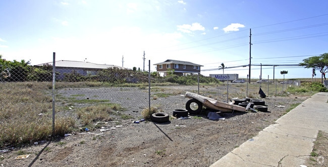
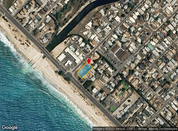
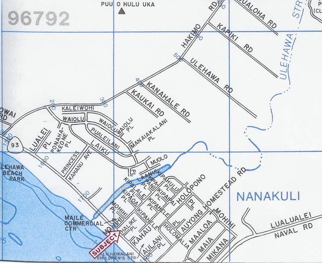
Property Record
87 Farrington Hwy, Waianae, HI 96792

Current Lease Availabilities
NEARBY LISTINGS FOR SALE OR LEASE
Property Detail
87 Farrington Hwy
Urban Honolulu, HI
Puu O Hulu
1-8-7-035-005-0000
LOT 1-B POR LP GR 10,011 19,737 SF DES
Commercialnec
Honolulu
D
Hawaii
15003C0194H
1-b
2024
0.45 AC
2025
Waianae
009705
Hawaii
DEMOGRAPHICS near 87 Farrington Hwy
1 Mile
3 Mile
5 Mile
2024 Total Population
7,601
21,479
43,707
2029 Population
7,321
20,295
41,371
Pop Growth 2024-2029
(3.68%)
(5.51%)
(5.34%)
Average Age
35
36
37
2024 Total Households
1,783
4,926
10,957
HH Growth 2024-2029
(4.43%)
(6.62%)
(6.18%)
Median Household Inc
$75,314
$89,644
$95,110
Avg Household Size
4.00
3.90
3.60
2024 Avg HH Vehicles
2.00
2.00
2.00
Median Home Value
$576,489
$501,661
$600,840
Median Year Built
1978
1980
1987
Nearby Places
Map Layers
Map Styles
 Street
 Aerial
- Restaurants
- Banks
- Shops
- Fitness
- Groceries
PUBLIC TRANSPORTATION
AIRPORT
Daniel K Inouye International
DRIVE
WALK
Distance
Daniel K Inouye International
35 min
23.5 mi
Freight Ports
Honolulu Harbor, Oahu
DRIVE
WALK
Distance
Honolulu Harbor, Oahu
44 min
27.7 mi
Nearby Properties
Address
Land Use
TOTAL SIZE
Lot Size
Zoning
Address
Land Use
TOTAL SIZE
Lot Size
Zoning
672.13 AC
F-1
Address
Land Use
TOTAL SIZE
Lot Size
Zoning
38,236 SF
2.52 AC
R-5
Address
Land Use
TOTAL SIZE
Lot Size
Zoning
19.54 AC
P-2
Address
Land Use
TOTAL SIZE
Lot Size
Zoning
38,282 SF
25 AC
I-2
Address
Land Use
TOTAL SIZE
Lot Size
Zoning
26,311 SF
4.26 AC
R-5
Address
Land Use
TOTAL SIZE
Lot Size
Zoning
448.48 AC
AG-2
Address
Land Use
TOTAL SIZE
Lot Size
Zoning
76,085 SF
5.66 AC
B-2
Address
Land Use
TOTAL SIZE
Lot Size
Zoning
18,846 SF
0.39 AC
B-2
Address
Land Use
TOTAL SIZE
Lot Size
Zoning
179.11 AC
AG-2
Address
Land Use
TOTAL SIZE
Lot Size
Zoning
15,210 SF
1.44 AC
B-2
Address
Land Use
TOTAL SIZE
Lot Size
Zoning
18,198 SF
1.69 AC
R-5
Address
Land Use
TOTAL SIZE
Lot Size
Zoning
12,417 SF
0.49 AC
R-5
Address
Land Use
TOTAL SIZE
Lot Size
Zoning
4,168 SF
113.07 AC
AG-2
Address
Land Use
TOTAL SIZE
Lot Size
Zoning
236.15 AC
P-2
Address
Land Use
TOTAL SIZE
Lot Size
Zoning
75.33 AC
AG-2
Address
Land Use
TOTAL SIZE
Lot Size
Zoning
1,380 SF
14.32 AC
AG-2
Address
Land Use
TOTAL SIZE
Lot Size
Zoning
1,302 SF
1.99 AC
B-2
Address
Land Use
TOTAL SIZE
Lot Size
Zoning
4,200 SF
3.32 AC
C
Address
Land Use
TOTAL SIZE
Lot Size
Zoning
11.73 AC
AG-1
Address
Land Use
TOTAL SIZE
Lot Size
Zoning
3,680 SF
1.31 AC
B-1
Address
Land Use
TOTAL SIZE
Lot Size
Zoning
22,787 SF
23.65 AC
AG-1
Address
Land Use
TOTAL SIZE
Lot Size
Zoning
21.14 AC
P-2
Address
Land Use
TOTAL SIZE
Lot Size
Zoning
9,396 SF
8 AC
AG-1
Address
Land Use
TOTAL SIZE
Lot Size
Zoning
1,968 SF
207.68 AC
AG-2
Address
Land Use
TOTAL SIZE
Lot Size
Zoning
7,534 SF
8.40 AC
AG-2
Address
Land Use
TOTAL SIZE
Lot Size
Zoning
14,844 SF
0.80 AC
B-1
Address
Land Use
TOTAL SIZE
Lot Size
Zoning
4,368 SF
0.59 AC
B-2
Address
Land Use
TOTAL SIZE
Lot Size
Zoning
10,460 SF
0.83 AC
B-2
Address
Land Use
TOTAL SIZE
Lot Size
Zoning
3.38 AC
B-2
Address
Land Use
TOTAL SIZE
Lot Size
Zoning
4,416 SF
7.75 AC
AG-2
The World's #1 Commercial Real Estate Marketplace
Connect with us
© 2025 CoStar Group
The information above has been obtained from sources believed reliable. While we do not doubt its accuracy we have not verified it and make no guarantee, warranty or representation about it. It is your responsibility to independently confirm its accuracy and completeness. Any projections, opinions, assumptions, or estimates used are for example only and do not represent the current or future performance of the property. The value of this transaction to you depends on tax and other factors which should be evaluated by your tax, financial, and legal advisors. You and your advisors should conduct a careful, independent investigation of the property to determine to your satisfaction the suitability of the property for your needs.