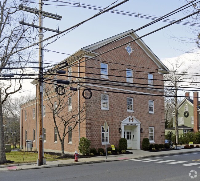
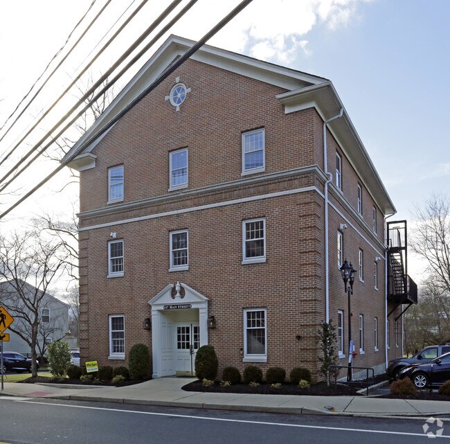
Property Record
87 Main St, Peapack, NJ 07977

Property Detail
87 Main St
15-00023-0000-00016
Somerset
Officebuilding
New Jersey
VN
16
AE The base floodplain where base flood elevations are provided. AE Zones are now used on new format FIRMs instead of A1-A30 Zones.
1.25 AC
2024
Route 78 East
2025
Northern New Jersey
052800
Lakewood-New Brunswick, NJ
8,760 SF
NEARBY LISTINGS FOR SALE OR LEASE
DEMOGRAPHICS near 87 Main St
1 mile
3 mile
5 mile
2025 Total Population
1,273
6,277
33,389
2030 Population
1,302
6,400
34,383
Pop Growth 2025-2030
+ 2.28%
+ 1.96%
+ 2.98%
Average Age
42
44
43
2025 Total Households
435
2,255
12,795
HH Growth 2025-2030
+ 2.30%
+ 2.00%
+ 3.17%
Median Household Inc
$172,159
$176,518
$181,423
Avg Household Size
2.70
2.70
2.60
2025 Avg HH Vehicles
2.00
2.00
2.00
Median Home Value
$855,029
$905,757
$780,128
Median Year Built
1969
1965
1984
Nearby Places
Map Layers
Map Styles
 Street
 Aerial
Transit
 Traffic
 Biking
Places
Listings with unknown addresses are not visible on the map
- Restaurants
- Banks
- Shops
- Fitness
- Groceries
PUBLIC TRANSPORTATION
COMMUTER RAIL
Peapack (Morris & Essex Gladstone Branch - NJ Transit Commuter Rail (NJ Transit))
Drive
Walk
Distance
Peapack (Morris & Essex Gladstone Branch - NJ Transit Commuter Rail (NJ Transit))
1 min
6 min
0.3 mi
Gladstone (Morris & Essex Gladstone Branch - NJ Transit Commuter Rail (NJ Transit))
Drive
Walk
Distance
Gladstone (Morris & Essex Gladstone Branch - NJ Transit Commuter Rail (NJ Transit))
2 min
17 min
0.9 mi
AIRPORT
Newark Liberty International
Drive
Walk
Distance
Newark Liberty International
43 min
34.7 mi
Freight Ports
New York Container Terminal
Drive
Walk
Distance
New York Container Terminal
52 min
41.8 mi
Nearby Properties
Address
Land Use
TOTAL SIZE
Lot Size
Zoning
Address
Land Use
TOTAL SIZE
Lot Size
Zoning
44.48 AC
ORL
Address
Land Use
TOTAL SIZE
Lot Size
Zoning
23.08 AC
OR
Address
Land Use
TOTAL SIZE
Lot Size
Zoning
1,290 SF
32 AC
R-5
Address
Land Use
TOTAL SIZE
Lot Size
Zoning
10,995 SF
14.26 AC
RE
Address
Land Use
TOTAL SIZE
Lot Size
Zoning
49,786 SF
13.84 AC
VN2
Address
Land Use
TOTAL SIZE
Lot Size
Zoning
32,578 SF
298.72 AC
R10
Address
Land Use
TOTAL SIZE
Lot Size
Zoning
31.95 AC
R3
Address
Land Use
TOTAL SIZE
Lot Size
Zoning
30,298 SF
33.47 AC
R10
Address
Land Use
TOTAL SIZE
Lot Size
Zoning
10,266 SF
3 AC
R10
Address
Land Use
TOTAL SIZE
Lot Size
Zoning
5,398 SF
4.90 AC
VN
Address
Land Use
TOTAL SIZE
Lot Size
Zoning
111.68 AC
R-10
Address
Land Use
TOTAL SIZE
Lot Size
Zoning
149.99 AC
R10
Address
Land Use
TOTAL SIZE
Lot Size
Zoning
22,833 SF
7 AC
R110
Address
Land Use
TOTAL SIZE
Lot Size
Zoning
Address
Land Use
TOTAL SIZE
Lot Size
Zoning
20,949 SF
5.05 AC
R110
Address
Land Use
TOTAL SIZE
Lot Size
Zoning
1,530 SF
3.37 AC
OR
Address
Land Use
TOTAL SIZE
Lot Size
Zoning
23.10 AC
LI
Address
Land Use
TOTAL SIZE
Lot Size
Zoning
64.70 AC
R110
Address
Land Use
TOTAL SIZE
Lot Size
Zoning
12,566 SF
4 AC
R10
Address
Land Use
TOTAL SIZE
Lot Size
Zoning
9,091 SF
6.78 AC
R10
Address
Land Use
TOTAL SIZE
Lot Size
Zoning
10,751 SF
6.23 AC
R10
Address
Land Use
TOTAL SIZE
Lot Size
Zoning
Address
Land Use
TOTAL SIZE
Lot Size
Zoning
12,524 SF
3 AC
R10
Address
Land Use
TOTAL SIZE
Lot Size
Zoning
23,417 SF
1.30 AC
VC
Address
Land Use
TOTAL SIZE
Lot Size
Zoning
12,589 SF
3 AC
RE
Address
Land Use
TOTAL SIZE
Lot Size
Zoning
24,881 SF
5 AC
R10
Address
Land Use
TOTAL SIZE
Lot Size
Zoning
11,271 SF
6.30 AC
R10
Address
Land Use
TOTAL SIZE
Lot Size
Zoning
17,652 SF
2 AC
R10
Address
Land Use
TOTAL SIZE
Lot Size
Zoning
16,028 SF
8 AC
R10
Address
Land Use
TOTAL SIZE
Lot Size
Zoning
13,902 SF
2.50 AC
RE
The World's #1 Commercial Real Estate Marketplace
Connect with us
© 2026 CoStar Group
The information above has been obtained from sources believed reliable. While we do not doubt its accuracy we have not verified it and make no guarantee, warranty or representation about it. It is your responsibility to independently confirm its accuracy and completeness. Any projections, opinions, assumptions, or estimates used are for example only and do not represent the current or future performance of the property. The value of this transaction to you depends on tax and other factors which should be evaluated by your tax, financial, and legal advisors. You and your advisors should conduct a careful, independent investigation of the property to determine to your satisfaction the suitability of the property for your needs.