Property Record
870 Hog Hollow Rd, Chesterfield, MO 63017

NEARBY LISTINGS FOR SALE OR LEASE
-
-
View all Chesterfield listings for lease on LoopNet.com
Property Detail
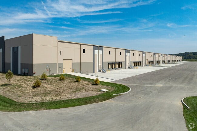
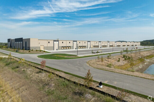
870 Hog Hollow Rd
St. Louis
River Valley Logistics Center
St. Louis, MO-IL
RIVER VALLEY LOGISTICS CENTER LOT 2
15Q-11-0013
St. Louis
Warehouse
Missouri
0
2
2025
28.46 AC
215105
Chesterfield/Hwy-40
DEMOGRAPHICS near 870 Hog Hollow Rd
1 Mile
3 Mile
5 Mile
2024 Total Population
1,731
31,151
128,386
2029 Population
1,701
30,496
128,353
Pop Growth 2024-2029
(1.73%)
(2.10%)
(0.03%)
Average Age
45
45
43
2024 Total Households
718
13,441
53,330
HH Growth 2024-2029
(1.81%)
(2.06%)
(0.11%)
Median Household Inc
$91,740
$98,550
$102,752
Avg Household Size
2.40
2.20
2.30
2024 Avg HH Vehicles
2.00
2.00
2.00
Median Home Value
$374,999
$350,667
$326,564
Median Year Built
1968
1975
1979
Nearby Places
Map Layers
Map Styles
 Street
 Aerial
- Restaurants
- Banks
- Shops
- Fitness
- Groceries
PUBLIC TRANSPORTATION
AIRPORT
St Louis Lambert International
DRIVE
WALK
Distance
St Louis Lambert International
25 min
14.4 mi
Freight Ports
Port Milwaukee
DRIVE
WALK
Distance
Port Milwaukee
445 min
387.6 mi
SALE & LEASE HISTORY
LISTING DATE
SALE/LEASE

Jun 10, 2024
For Lease
Nearby Properties
Address
Land Use
TOTAL SIZE
Lot Size
Zoning
Address
Land Use
TOTAL SIZE
Lot Size
Zoning
200,372 SF
121.45 AC
105FPNU
Address
Land Use
TOTAL SIZE
Lot Size
Zoning
43,574 SF
55.62 AC
NU
Address
Land Use
TOTAL SIZE
Lot Size
Zoning
1,298,224 SF
194.08 AC
C-8
Address
Land Use
TOTAL SIZE
Lot Size
Zoning
3,220 SF
31.26 AC
CB
Address
Land Use
TOTAL SIZE
Lot Size
Zoning
587,809 SF
36.69 AC
105NU
Address
Land Use
TOTAL SIZE
Lot Size
Zoning
247,860 SF
21.11 AC
105MU
Address
Land Use
TOTAL SIZE
Lot Size
Zoning
68,279 SF
95.59 AC
NU
Address
Land Use
TOTAL SIZE
Lot Size
Zoning
13.45 AC
PD-M
Address
Land Use
TOTAL SIZE
Lot Size
Zoning
340,320 SF
55.62 AC
NU
Address
Land Use
TOTAL SIZE
Lot Size
Zoning
302,420 SF
13.97 AC
NU
Address
Land Use
TOTAL SIZE
Lot Size
Zoning
42,037 SF
193.91 AC
NU
Address
Land Use
TOTAL SIZE
Lot Size
Zoning
36.41 AC
R2
Address
Land Use
TOTAL SIZE
Lot Size
Zoning
389,367 SF
29.15 AC
R6
Address
Land Use
TOTAL SIZE
Lot Size
Zoning
217,030 SF
16.76 AC
104R-4
Address
Land Use
TOTAL SIZE
Lot Size
Zoning
241,519 SF
19.30 AC
R7
Address
Land Use
TOTAL SIZE
Lot Size
Zoning
5,712 SF
9.90 AC
105R3
Address
Land Use
TOTAL SIZE
Lot Size
Zoning
119,860 SF
8.62 AC
NU
Address
Land Use
TOTAL SIZE
Lot Size
Zoning
115,020 SF
5.20 AC
NU
Address
Land Use
TOTAL SIZE
Lot Size
Zoning
108,055 SF
31.30 AC
CB
Address
Land Use
TOTAL SIZE
Lot Size
Zoning
168,004 SF
12.31 AC
R6A
Address
Land Use
TOTAL SIZE
Lot Size
Zoning
135,540 SF
6.56 AC
82CB
Address
Land Use
TOTAL SIZE
Lot Size
Zoning
107,793 SF
10.39 AC
105C8
Address
Land Use
TOTAL SIZE
Lot Size
Zoning
174,337 SF
10.67 AC
R2
Address
Land Use
TOTAL SIZE
Lot Size
Zoning
145,901 SF
8.28 AC
C-8
Address
Land Use
TOTAL SIZE
Lot Size
Zoning
128,942 SF
4.48 AC
R7
Address
Land Use
TOTAL SIZE
Lot Size
Zoning
177,209 SF
15.56 AC
FPR3
Address
Land Use
TOTAL SIZE
Lot Size
Zoning
121,423 SF
11.13 AC
82GC
Address
Land Use
TOTAL SIZE
Lot Size
Zoning
185,938 SF
10.98 AC
R6
Address
Land Use
TOTAL SIZE
Lot Size
Zoning
11.12 AC
82C
The World's #1 Commercial Real Estate Marketplace
Connect with us
© 2026 CoStar Group
The information above has been obtained from sources believed reliable. While we do not doubt its accuracy we have not verified it and make no guarantee, warranty or representation about it. It is your responsibility to independently confirm its accuracy and completeness. Any projections, opinions, assumptions, or estimates used are for example only and do not represent the current or future performance of the property. The value of this transaction to you depends on tax and other factors which should be evaluated by your tax, financial, and legal advisors. You and your advisors should conduct a careful, independent investigation of the property to determine to your satisfaction the suitability of the property for your needs.