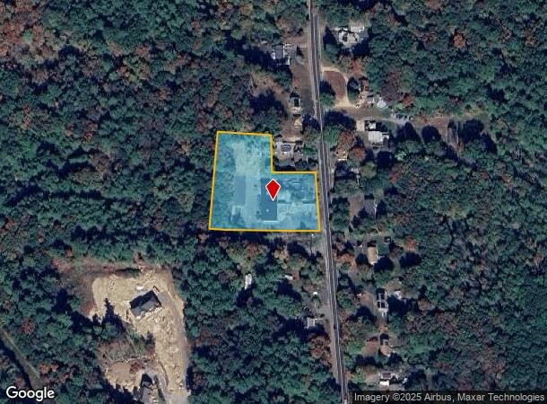
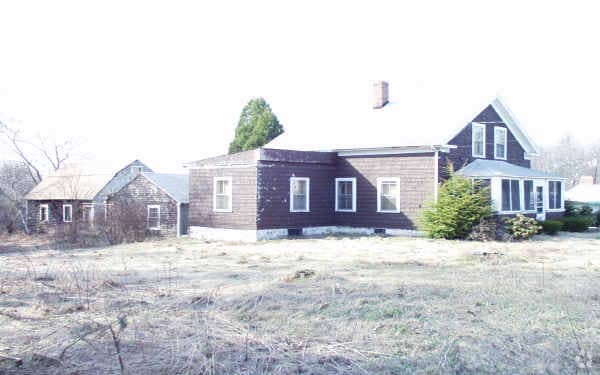
Property Record
870 S Main St, Bellingham, MA 02019


NEARBY LISTINGS FOR SALE OR LEASE
Property Detail
870 S Main St
Commercialofficeresidentialmixeduse
Norfolk
X
Massachusetts
25021C0311F
2 AC
0
I-95 Corridor South
2025
Boston
443104
Boston-Cambridge-Newton, MA-NH
14,000 SF
BELL-000071-000006
DEMOGRAPHICS near 870 S Main St
1 Mile
3 Mile
5 Mile
2024 Total Population
2,860
21,707
93,698
2029 Population
2,846
21,541
92,917
Pop Growth 2024-2029
(0.49%)
(0.76%)
(0.83%)
Average Age
41
41
41
2024 Total Households
1,030
8,185
37,312
HH Growth 2024-2029
(0.49%)
(0.79%)
(0.90%)
Median Household Inc
$129,121
$109,658
$78,573
Avg Household Size
2.80
2.60
2.40
2024 Avg HH Vehicles
2.00
2.00
2.00
Median Home Value
$431,276
$397,604
$378,973
Median Year Built
1978
1976
1966
Nearby Places
Map Layers
Map Styles
 Street
 Aerial
- Restaurants
- Banks
- Shops
- Fitness
- Groceries
PUBLIC TRANSPORTATION
COMMUTER RAIL
Forge Park/Route 495 (Franklin Line - Massachusetts Bay Transportation Authority Commuter Rail (Purple Line))
DRIVE
WALK
Distance
Forge Park/Route 495 (Franklin Line - Massachusetts Bay Transportation Authority Commuter Rail (Purple Line))
9 min
4.4 mi
Franklin (Franklin Line - Massachusetts Bay Transportation Authority Commuter Rail (Purple Line))
DRIVE
WALK
Distance
Franklin (Franklin Line - Massachusetts Bay Transportation Authority Commuter Rail (Purple Line))
12 min
6.2 mi
AIRPORT
Rhode Island Tf Green International
DRIVE
WALK
Distance
Rhode Island Tf Green International
40 min
26.4 mi
Worcester Regional
DRIVE
WALK
Distance
Worcester Regional
52 min
36.2 mi
Freight Ports
Port of Boston
DRIVE
WALK
Distance
Port of Boston
64 min
41.1 mi
Nearby Properties
Address
Land Use
TOTAL SIZE
Lot Size
Zoning
Address
Land Use
TOTAL SIZE
Lot Size
Zoning
20.97 AC
CRPC
Address
Land Use
TOTAL SIZE
Lot Size
Zoning
14.82 AC
AGR
Address
Land Use
TOTAL SIZE
Lot Size
Zoning
345,000 SF
60.44 AC
BUS1
Address
Land Use
TOTAL SIZE
Lot Size
Zoning
231,817 SF
35.01 AC
IND
Address
Land Use
TOTAL SIZE
Lot Size
Zoning
238,602 SF
109.37 AC
Address
Land Use
TOTAL SIZE
Lot Size
Zoning
238,975 SF
33.82 AC
IND
Address
Land Use
TOTAL SIZE
Lot Size
Zoning
451,000 SF
90.70 AC
IND
Address
Land Use
TOTAL SIZE
Lot Size
Zoning
75,140 SF
39.40 AC
Address
Land Use
TOTAL SIZE
Lot Size
Zoning
208,826 SF
18.96 AC
IND
Address
Land Use
TOTAL SIZE
Lot Size
Zoning
203,792 SF
27.93 AC
IND
Address
Land Use
TOTAL SIZE
Lot Size
Zoning
51.71 AC
CRPC
Address
Land Use
TOTAL SIZE
Lot Size
Zoning
124,320 SF
10 AC
BUS1
Address
Land Use
TOTAL SIZE
Lot Size
Zoning
112,894 SF
9.96 AC
Address
Land Use
TOTAL SIZE
Lot Size
Zoning
154,000 SF
21.92 AC
Address
Land Use
TOTAL SIZE
Lot Size
Zoning
14.05 AC
Address
Land Use
TOTAL SIZE
Lot Size
Zoning
153,408 SF
10.43 AC
Address
Land Use
TOTAL SIZE
Lot Size
Zoning
128,693 SF
28.30 AC
Address
Land Use
TOTAL SIZE
Lot Size
Zoning
79,522 SF
24.21 AC
CRPC
Address
Land Use
TOTAL SIZE
Lot Size
Zoning
115,225 SF
10.79 AC
M
Address
Land Use
TOTAL SIZE
Lot Size
Zoning
143,208 SF
23.22 AC
Address
Land Use
TOTAL SIZE
Lot Size
Zoning
45,454 SF
4.78 AC
CRPC
Address
Land Use
TOTAL SIZE
Lot Size
Zoning
23.19 AC
C2
Address
Land Use
TOTAL SIZE
Lot Size
Zoning
117,682 SF
10.05 AC
Address
Land Use
TOTAL SIZE
Lot Size
Zoning
49,920 SF
8.77 AC
IND
Address
Land Use
TOTAL SIZE
Lot Size
Zoning
110,931 SF
46.97 AC
Address
Land Use
TOTAL SIZE
Lot Size
Zoning
8.25 AC
C2
Address
Land Use
TOTAL SIZE
Lot Size
Zoning
43,548 SF
7.80 AC
Address
Land Use
TOTAL SIZE
Lot Size
Zoning
65,698 SF
19.07 AC
B
Address
Land Use
TOTAL SIZE
Lot Size
Zoning
34,933 SF
6.37 AC
IND
Address
Land Use
TOTAL SIZE
Lot Size
Zoning
84,426 SF
6.60 AC
The World's #1 Commercial Real Estate Marketplace
Connect with us
© 2025 CoStar Group
The information above has been obtained from sources believed reliable. While we do not doubt its accuracy we have not verified it and make no guarantee, warranty or representation about it. It is your responsibility to independently confirm its accuracy and completeness. Any projections, opinions, assumptions, or estimates used are for example only and do not represent the current or future performance of the property. The value of this transaction to you depends on tax and other factors which should be evaluated by your tax, financial, and legal advisors. You and your advisors should conduct a careful, independent investigation of the property to determine to your satisfaction the suitability of the property for your needs.