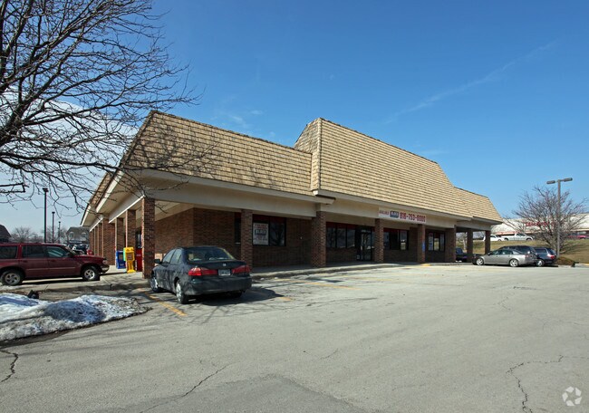
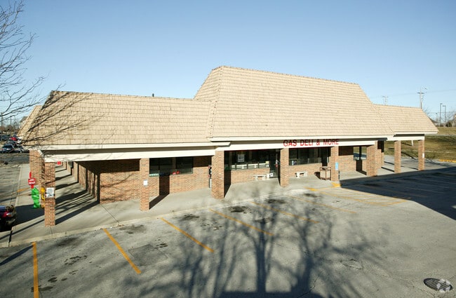
Property Record
8700 Lackman Rd, Lenexa, KS 66219


Property Detail
8700 Lackman Rd
IP13000000-0001
COUNTRY HILL CENTER LT 1 EX BG NW CR E 170 TO NE/L SE 63.71 S 27.11 NW 73.19 W 164.74 TO W/L N 19 TO POB IN ST LEC 833 2 1
Regionalshoppingcenterormallwithanchorstore
Johnson
CP2
Kansas
B and X Area of moderate flood hazard, usually the area between the limits of the 100-year and 500-year floods.
1
2025
0.99 AC
2025
Northwest Johnson County
052415
Kansas City
8,178 SF
Kansas City, MO-KS
NEARBY LISTINGS FOR SALE OR LEASE
DEMOGRAPHICS near 8700 Lackman Rd
1 mile
3 mile
5 mile
2025 Total Population
14,728
65,212
190,490
2030 Population
15,105
67,161
196,720
Pop Growth 2025-2030
+ 2.56%
+ 2.99%
+ 3.27%
Average Age
42
40
40
2025 Total Households
6,625
28,283
81,283
HH Growth 2025-2030
+ 2.91%
+ 3.17%
+ 3.34%
Median Household Inc
$88,933
$88,433
$89,636
Avg Household Size
2.20
2.20
2.30
2025 Avg HH Vehicles
2.00
2.00
2.00
Median Home Value
$349,183
$347,230
$345,337
Median Year Built
1987
1984
1984
Nearby Places
Map Layers
Map Styles
 Street
 Aerial
Layers
 Traffic
 Biking
Places
Listings with unknown addresses are not visible on the map
- Restaurants
- Banks
- Shops
- Fitness
- Groceries
PUBLIC TRANSPORTATION
AIRPORT
Kansas City International
Drive
Walk
Distance
Kansas City International
42 min
33.9 mi
Nearby Properties
Address
Land Use
TOTAL SIZE
Lot Size
Zoning
Address
Land Use
TOTAL SIZE
Lot Size
Zoning
787,363 SF
88.91 AC
RP5
Address
Land Use
TOTAL SIZE
Lot Size
Zoning
203,079 SF
8.10 AC
BP2
Address
Land Use
TOTAL SIZE
Lot Size
Zoning
202,842 SF
10.20 AC
PD
Address
Land Use
TOTAL SIZE
Lot Size
Zoning
208,693 SF
22.30 AC
BP1
Address
Land Use
TOTAL SIZE
Lot Size
Zoning
133,932 SF
3.29 AC
CC
Address
Land Use
TOTAL SIZE
Lot Size
Zoning
144,755 SF
22.19 AC
BP2
Address
Land Use
TOTAL SIZE
Lot Size
Zoning
512,680 SF
18.03 AC
R-1
Address
Land Use
TOTAL SIZE
Lot Size
Zoning
304,926 SF
7.87 AC
CC
Address
Land Use
TOTAL SIZE
Lot Size
Zoning
166,039 SF
35.38 AC
R-1
Address
Land Use
TOTAL SIZE
Lot Size
Zoning
129,784 SF
36.15 AC
CPO
Address
Land Use
TOTAL SIZE
Lot Size
Zoning
49,029 SF
15.02 AC
BP1
Address
Land Use
TOTAL SIZE
Lot Size
Zoning
222,396 SF
14.76 AC
BP2
Address
Land Use
TOTAL SIZE
Lot Size
Zoning
69,872 SF
1.91 AC
CC
Address
Land Use
TOTAL SIZE
Lot Size
Zoning
146,143 SF
10.59 AC
CP-2
Address
Land Use
TOTAL SIZE
Lot Size
Zoning
120,492 SF
10 AC
R1
Address
Land Use
TOTAL SIZE
Lot Size
Zoning
411,435 SF
17.41 AC
CP-2
Address
Land Use
TOTAL SIZE
Lot Size
Zoning
141,340 SF
19.92 AC
R1
Address
Land Use
TOTAL SIZE
Lot Size
Zoning
72,994 SF
7.99 AC
RP3
Address
Land Use
TOTAL SIZE
Lot Size
Zoning
75,010 SF
5.53 AC
PD
Address
Land Use
TOTAL SIZE
Lot Size
Zoning
75,010 SF
24.78 AC
RP2
Address
Land Use
TOTAL SIZE
Lot Size
Zoning
204,922 SF
14.73 AC
BP2
Address
Land Use
TOTAL SIZE
Lot Size
Zoning
49,282 SF
11.89 AC
RP1
Address
Land Use
TOTAL SIZE
Lot Size
Zoning
85,940 SF
9.08 AC
RGA
Address
Land Use
TOTAL SIZE
Lot Size
Zoning
139,880 SF
17.18 AC
R1
Address
Land Use
TOTAL SIZE
Lot Size
Zoning
89,002 SF
8.77 AC
R-1
Address
Land Use
TOTAL SIZE
Lot Size
Zoning
36,903 SF
0.55 AC
CC
Address
Land Use
TOTAL SIZE
Lot Size
Zoning
88,866 SF
21.54 AC
RS
Address
Land Use
TOTAL SIZE
Lot Size
Zoning
143,055 SF
8.11 AC
BP1
Address
Land Use
TOTAL SIZE
Lot Size
Zoning
85,469 SF
10.32 AC
CPO
Address
Land Use
TOTAL SIZE
Lot Size
Zoning
56,347 SF
0.76 AC
CC
The World's #1 Commercial Real Estate Marketplace
Connect with us
© 2026 CoStar Group
The information above has been obtained from sources believed reliable. While we do not doubt its accuracy we have not verified it and make no guarantee, warranty or representation about it. It is your responsibility to independently confirm its accuracy and completeness. Any projections, opinions, assumptions, or estimates used are for example only and do not represent the current or future performance of the property. The value of this transaction to you depends on tax and other factors which should be evaluated by your tax, financial, and legal advisors. You and your advisors should conduct a careful, independent investigation of the property to determine to your satisfaction the suitability of the property for your needs.