Property Record
8700 Mack Ave, Detroit, MI 48214


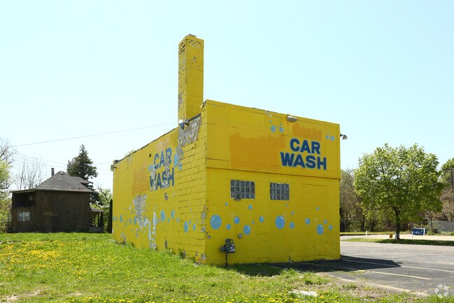
This Property Is For Sale
NEARBY LISTINGS FOR SALE OR LEASE
Property Detail
8700 Mack Ave
19-000881
Wesson Estate
Commercialnec
S MACK 93&92 WESSON EST SUB L28 P6 PLATS, W C R 19/59 43.6 X 109.42A
X
Wayne
26163C0301F
Michigan
2025
0.11 AC
2025
Detroit E of Woodward
513800
Detroit
1,032 SF
Detroit-Warren-Dearborn, MI
DEMOGRAPHICS near 8700 Mack Ave
1 Mile
3 Mile
5 Mile
2024 Total Population
15,061
84,116
272,600
2029 Population
15,423
84,696
272,071
Pop Growth 2024-2029
+ 2.40%
+ 0.69%
(0.19%)
Average Age
42
42
38
2024 Total Households
6,407
39,194
113,188
HH Growth 2024-2029
+ 2.47%
+ 0.18%
(0.24%)
Median Household Inc
$34,437
$34,058
$38,599
Avg Household Size
2.20
2.00
2.30
2024 Avg HH Vehicles
1.00
1.00
1.00
Median Home Value
$90,663
$95,616
$95,957
Median Year Built
1946
1955
1949
Nearby Places
Map Layers
Map Styles
 Street
 Aerial
- Restaurants
- Banks
- Shops
- Fitness
- Groceries
PUBLIC TRANSPORTATION
COMMUTER RAIL
DRIVE
WALK
Distance
12 min
5.4 mi
DRIVE
WALK
Distance
20 min
7.8 mi
AIRPORT
Windsor International
DRIVE
WALK
Distance
Windsor International
33 min
13.7 mi
Detroit Metro Wayne County
DRIVE
WALK
Distance
Detroit Metro Wayne County
41 min
26.3 mi
Nearby Properties
Address
Land Use
TOTAL SIZE
Lot Size
Zoning
Address
Land Use
TOTAL SIZE
Lot Size
Zoning
3,793,609 SF
265.70 AC
M4
Address
Land Use
TOTAL SIZE
Lot Size
Zoning
2,958,207 SF
277.38 AC
M4
Address
Land Use
TOTAL SIZE
Lot Size
Zoning
874,160 SF
9.91 AC
R6
Address
Land Use
TOTAL SIZE
Lot Size
Zoning
460,475 SF
3.49 AC
R6
Address
Land Use
TOTAL SIZE
Lot Size
Zoning
286,897 SF
416 AC
R6
Address
Land Use
TOTAL SIZE
Lot Size
Zoning
2,005,073 SF
108.66 AC
M4
Address
Land Use
TOTAL SIZE
Lot Size
Zoning
461,840 SF
4.78 AC
R6
Address
Land Use
TOTAL SIZE
Lot Size
Zoning
82,528 SF
6.03 AC
PD
Address
Land Use
TOTAL SIZE
Lot Size
Zoning
384,217 SF
3.40 AC
R6
Address
Land Use
TOTAL SIZE
Lot Size
Zoning
396,484 SF
18.18 AC
PD
Address
Land Use
TOTAL SIZE
Lot Size
Zoning
381,920 SF
0.68 AC
R6
Address
Land Use
TOTAL SIZE
Lot Size
Zoning
192,465 SF
4.63 AC
PD
Address
Land Use
TOTAL SIZE
Lot Size
Zoning
929,400 SF
52.48 AC
M4
Address
Land Use
TOTAL SIZE
Lot Size
Zoning
167,000 SF
1.83 AC
PD
Address
Land Use
TOTAL SIZE
Lot Size
Zoning
996,200 SF
2.14 AC
Address
Land Use
TOTAL SIZE
Lot Size
Zoning
320,640 SF
1.12 AC
PD
Address
Land Use
TOTAL SIZE
Lot Size
Zoning
473,209 SF
6.22 AC
M3
Address
Land Use
TOTAL SIZE
Lot Size
Zoning
281,265 SF
5.24 AC
R6
Address
Land Use
TOTAL SIZE
Lot Size
Zoning
482,649 SF
M4
Address
Land Use
TOTAL SIZE
Lot Size
Zoning
648,928 SF
5.46 AC
R6
Address
Land Use
TOTAL SIZE
Lot Size
Zoning
506,404 SF
198 AC
M4
Address
Land Use
TOTAL SIZE
Lot Size
Zoning
525,172 SF
2.25 AC
PD
Address
Land Use
TOTAL SIZE
Lot Size
Zoning
65,625 SF
2.70 AC
PD
Address
Land Use
TOTAL SIZE
Lot Size
Zoning
227,921 SF
1.84 AC
PD
Address
Land Use
TOTAL SIZE
Lot Size
Zoning
298,117 SF
15.97 AC
PD
Address
Land Use
TOTAL SIZE
Lot Size
Zoning
144,308 SF
776 AC
SD4
Address
Land Use
TOTAL SIZE
Lot Size
Zoning
892,351 SF
92.45 AC
I
Address
Land Use
TOTAL SIZE
Lot Size
Zoning
267,185 SF
13.08 AC
PD
Address
Land Use
TOTAL SIZE
Lot Size
Zoning
191,837 SF
16.99 AC
PD
Address
Land Use
TOTAL SIZE
Lot Size
Zoning
156,634 SF
The World's #1 Commercial Real Estate Marketplace
Connect with us
© 2026 CoStar Group
The information above has been obtained from sources believed reliable. While we do not doubt its accuracy we have not verified it and make no guarantee, warranty or representation about it. It is your responsibility to independently confirm its accuracy and completeness. Any projections, opinions, assumptions, or estimates used are for example only and do not represent the current or future performance of the property. The value of this transaction to you depends on tax and other factors which should be evaluated by your tax, financial, and legal advisors. You and your advisors should conduct a careful, independent investigation of the property to determine to your satisfaction the suitability of the property for your needs.