Property Record
8700 N Oracle Rd, Tucson, AZ 85704


Save to a Folder
{{folder.Name}}
{{folder.ListingIds.length}} Properties
{{folder.ListingIds.length}} Property
Create a New Folder
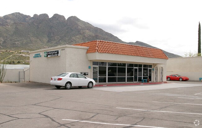
Property Detail
8700 N Oracle Rd
Tucson, AZ
SUNNYSLOPE TOWNHOUSES LOT 7 & PTN ABAND STREET & SUNNYSLOPE SWLY PTN LOT 1 & PTN ABAND HWY
225-14-168B
PIMA
Storemultistory
Arizona
B and X Area of moderate flood hazard, usually the area between the limits of the 100-year and 500-year floods.
7
2025
0.41 AC
2026
Foothills
004713
Tucson
4,447 SF
NEARBY LISTINGS FOR SALE OR LEASE
DEMOGRAPHICS near 8700 N Oracle Rd
1 mile
3 mile
5 mile
2025 Total Population
4,954
35,647
116,821
2030 Population
5,045
36,707
119,822
Pop Growth 2025-2030
+ 1.84%
+ 2.97%
+ 2.57%
Average Age
44
48
45
2025 Total Households
2,351
16,419
51,105
HH Growth 2025-2030
+ 1.91%
+ 3.11%
+ 2.70%
Median Household Inc
$71,841
$100,078
$97,592
Avg Household Size
2.10
2.10
2.20
2025 Avg HH Vehicles
2.00
2.00
2.00
Median Home Value
$457,812
$472,199
$435,596
Median Year Built
1978
1985
1989
Nearby Places
Map Layers
Map Styles
 Street
 Aerial
Layers
 Traffic
 Biking
Places
Listings with unknown addresses are not visible on the map
- Restaurants
- Banks
- Shops
- Fitness
- Groceries
PUBLIC TRANSPORTATION
AIRPORT
Tucson International
Drive
Walk
Distance
Tucson International
35 min
19.3 mi
Nearby Properties
Address
Land Use
TOTAL SIZE
Lot Size
Zoning
Address
Land Use
TOTAL SIZE
Lot Size
Zoning
320,757 SF
15.73 AC
Address
Land Use
TOTAL SIZE
Lot Size
Zoning
272,429 SF
36.97 AC
R1144
Address
Land Use
TOTAL SIZE
Lot Size
Zoning
388,226 SF
22 AC
CR5
Address
Land Use
TOTAL SIZE
Lot Size
Zoning
21,126 SF
49.39 AC
CR1
Address
Land Use
TOTAL SIZE
Lot Size
Zoning
352,158 SF
15.89 AC
Address
Land Use
TOTAL SIZE
Lot Size
Zoning
89,041 SF
35.51 AC
Address
Land Use
TOTAL SIZE
Lot Size
Zoning
284,407 SF
15.04 AC
Address
Land Use
TOTAL SIZE
Lot Size
Zoning
206,109 SF
7.12 AC
PAD
Address
Land Use
TOTAL SIZE
Lot Size
Zoning
223,640 SF
18.06 AC
CB1
Address
Land Use
TOTAL SIZE
Lot Size
Zoning
222,779 SF
8.83 AC
CR5
Address
Land Use
TOTAL SIZE
Lot Size
Zoning
4,977 SF
1.75 AC
Address
Land Use
TOTAL SIZE
Lot Size
Zoning
252,531 SF
10.64 AC
CR5
Address
Land Use
TOTAL SIZE
Lot Size
Zoning
330,372 SF
8.78 AC
Address
Land Use
TOTAL SIZE
Lot Size
Zoning
204,223 SF
36.08 AC
CR1
Address
Land Use
TOTAL SIZE
Lot Size
Zoning
188,065 SF
11.65 AC
CR5
Address
Land Use
TOTAL SIZE
Lot Size
Zoning
230,408 SF
14.16 AC
CR5
Address
Land Use
TOTAL SIZE
Lot Size
Zoning
343,624 SF
27.10 AC
Address
Land Use
TOTAL SIZE
Lot Size
Zoning
103,699 SF
4.34 AC
R4
Address
Land Use
TOTAL SIZE
Lot Size
Zoning
27,464 SF
4.63 AC
PAD
Address
Land Use
TOTAL SIZE
Lot Size
Zoning
165,955 SF
9.01 AC
RS
Address
Land Use
TOTAL SIZE
Lot Size
Zoning
115,748 SF
8.87 AC
CB1
Address
Land Use
TOTAL SIZE
Lot Size
Zoning
165,072 SF
10.97 AC
TR
Address
Land Use
TOTAL SIZE
Lot Size
Zoning
152,223 SF
8.72 AC
PAD
Address
Land Use
TOTAL SIZE
Lot Size
Zoning
59,868 SF
8.91 AC
PSC
Address
Land Use
TOTAL SIZE
Lot Size
Zoning
130,481 SF
10.69 AC
PAD
Address
Land Use
TOTAL SIZE
Lot Size
Zoning
45,000 SF
8.50 AC
C1
Address
Land Use
TOTAL SIZE
Lot Size
Zoning
152,132 SF
8.88 AC
CR5
Address
Land Use
TOTAL SIZE
Lot Size
Zoning
132,932 SF
11.58 AC
R6
Address
Land Use
TOTAL SIZE
Lot Size
Zoning
87,310 SF
9.36 AC
PAD
Address
Land Use
TOTAL SIZE
Lot Size
Zoning
93,318 SF
4.50 AC
TR
The World's #1 Commercial Real Estate Marketplace
Connect with us
© 2026 CoStar Group
The information above has been obtained from sources believed reliable. While we do not doubt its accuracy we have not verified it and make no guarantee, warranty or representation about it. It is your responsibility to independently confirm its accuracy and completeness. Any projections, opinions, assumptions, or estimates used are for example only and do not represent the current or future performance of the property. The value of this transaction to you depends on tax and other factors which should be evaluated by your tax, financial, and legal advisors. You and your advisors should conduct a careful, independent investigation of the property to determine to your satisfaction the suitability of the property for your needs.