Property Record
8700 Princeton Rd, Rowlett, TX 75089

NEARBY LISTINGS FOR SALE OR LEASE
-
-
-
No Photo
-
-
-
-
-
View all Rowlett listings for sale on LoopNet.com
Property Detail
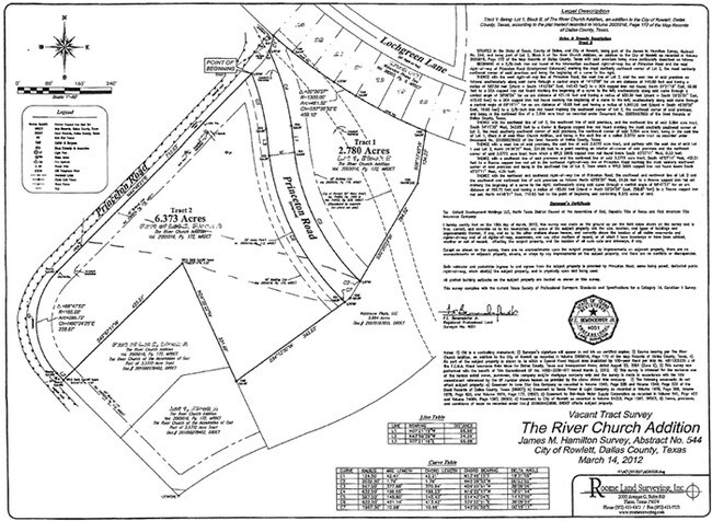
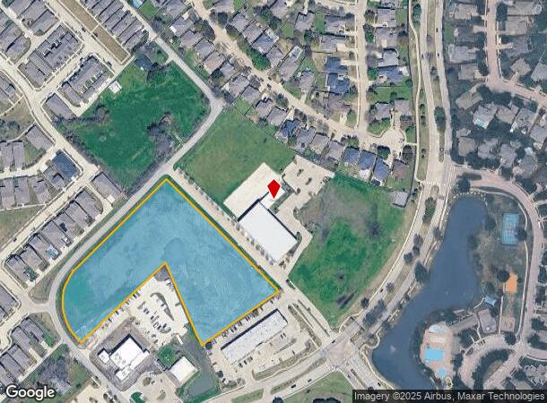
8700 Princeton Rd
Dallas-Fort Worth-Arlington, TX
Bullitt Multisport
440007800B0010000
BULLITT MULTISPORT BLK B LT 1 ACS 5.176 INT201400307111 DD11142014 CO-DC 0169000B00100 2CW0169000B
Vacantlandnec
Dallas
X
Texas
48113C0235K
1
2024
5.18 AC
2025
Garland
018143
Dallas/Ft Worth
DEMOGRAPHICS near 8700 Princeton Rd
1 Mile
3 Mile
5 Mile
2024 Total Population
8,442
50,655
170,466
2029 Population
8,336
53,938
191,105
Pop Growth 2024-2029
(1.26%)
+ 6.48%
+ 12.11%
Average Age
37
38
38
2024 Total Households
2,650
16,516
57,409
HH Growth 2024-2029
(1.40%)
+ 6.81%
+ 12.54%
Median Household Inc
$108,009
$108,314
$106,866
Avg Household Size
3.10
3.00
2.90
2024 Avg HH Vehicles
2.00
2.00
2.00
Median Home Value
$281,457
$280,264
$292,343
Median Year Built
2000
1998
1998
Nearby Places
Map Layers
Map Styles
 Street
 Aerial
- Restaurants
- Banks
- Shops
- Fitness
- Groceries
PUBLIC TRANSPORTATION
AIRPORT
Dallas Love Field
DRIVE
WALK
Distance
Dallas Love Field
42 min
26.6 mi
Dallas-Fort Worth International
DRIVE
WALK
Distance
Dallas-Fort Worth International
48 min
40.6 mi
Freight Ports
Port of Shreveport
DRIVE
WALK
Distance
Port of Shreveport
216 min
190.4 mi
SALE & LEASE HISTORY
LISTING DATE
SALE/LEASE

Mar 22, 2020
For Sale
Aug 29, 2017
For Sale
Apr 23, 2019
For Sale
Nearby Properties
Address
Land Use
TOTAL SIZE
Lot Size
Zoning
Address
Land Use
TOTAL SIZE
Lot Size
Zoning
231,434 SF
11.27 AC
Z06
Address
Land Use
TOTAL SIZE
Lot Size
Zoning
252,909 SF
11.73 AC
Address
Land Use
TOTAL SIZE
Lot Size
Zoning
320,801 SF
10.14 AC
Z236
Address
Land Use
TOTAL SIZE
Lot Size
Zoning
250,602 SF
4.99 AC
Z01
Address
Land Use
TOTAL SIZE
Lot Size
Zoning
366,600 SF
8.09 AC
Z06
Address
Land Use
TOTAL SIZE
Lot Size
Zoning
228,458 SF
5.56 AC
Z236
Address
Land Use
TOTAL SIZE
Lot Size
Zoning
427,231 SF
9.96 AC
Z38
Address
Land Use
TOTAL SIZE
Lot Size
Zoning
286,659 SF
9.94 AC
Z236
Address
Land Use
TOTAL SIZE
Lot Size
Zoning
259,280 SF
5.15 AC
Z01
Address
Land Use
TOTAL SIZE
Lot Size
Zoning
60,593 SF
35.93 AC
Z06
Address
Land Use
TOTAL SIZE
Lot Size
Zoning
223,052 SF
5.81 AC
Z236
Address
Land Use
TOTAL SIZE
Lot Size
Zoning
43,600 SF
62.86 AC
Z306
Address
Land Use
TOTAL SIZE
Lot Size
Zoning
420,500 SF
33.25 AC
Address
Land Use
TOTAL SIZE
Lot Size
Zoning
85,793 SF
6.90 AC
Address
Land Use
TOTAL SIZE
Lot Size
Zoning
261,000 SF
1 AC
Z318
Address
Land Use
TOTAL SIZE
Lot Size
Zoning
244,338 SF
4.44 AC
Address
Land Use
TOTAL SIZE
Lot Size
Zoning
271,051 SF
10.28 AC
Z01
Address
Land Use
TOTAL SIZE
Lot Size
Zoning
226,800 SF
4.98 AC
Z340
Address
Land Use
TOTAL SIZE
Lot Size
Zoning
83,296 SF
14.88 AC
Z01
Address
Land Use
TOTAL SIZE
Lot Size
Zoning
151,893 SF
5.40 AC
Z308
Address
Land Use
TOTAL SIZE
Lot Size
Zoning
82,847 SF
4.87 AC
Z236
Address
Land Use
TOTAL SIZE
Lot Size
Zoning
133,111 SF
2.73 AC
Z06
Address
Land Use
TOTAL SIZE
Lot Size
Zoning
67,677 SF
3.88 AC
Z06
Address
Land Use
TOTAL SIZE
Lot Size
Zoning
140,000 SF
12.76 AC
Address
Land Use
TOTAL SIZE
Lot Size
Zoning
141,200 SF
10.81 AC
Address
Land Use
TOTAL SIZE
Lot Size
Zoning
52,797 SF
5.41 AC
Z92
Address
Land Use
TOTAL SIZE
Lot Size
Zoning
147.23 AC
Z114
Address
Land Use
TOTAL SIZE
Lot Size
Zoning
0.02 AC
Z236
Address
Land Use
TOTAL SIZE
Lot Size
Zoning
61,782 SF
2.50 AC
Z01
Address
Land Use
TOTAL SIZE
Lot Size
Zoning
65,518 SF
1.34 AC
Z01
The World's #1 Commercial Real Estate Marketplace
Connect with us
© 2025 CoStar Group
The information above has been obtained from sources believed reliable. While we do not doubt its accuracy we have not verified it and make no guarantee, warranty or representation about it. It is your responsibility to independently confirm its accuracy and completeness. Any projections, opinions, assumptions, or estimates used are for example only and do not represent the current or future performance of the property. The value of this transaction to you depends on tax and other factors which should be evaluated by your tax, financial, and legal advisors. You and your advisors should conduct a careful, independent investigation of the property to determine to your satisfaction the suitability of the property for your needs.