Property Record
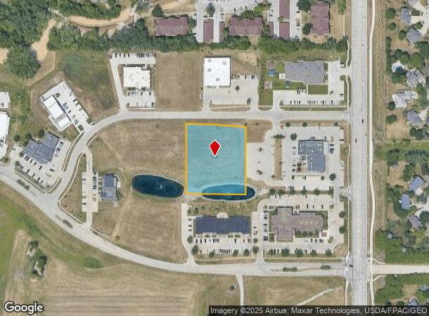
8700 Thomas Ave, Johnston, IA 50131
NEARBY LISTINGS FOR SALE OR LEASE
Property Detail
8700 Thomas Ave
Des Moines-West Des Moines, IA
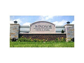
Windsor Office Park Plat 1
241-01040018000
LOT 18 WINDSOR OFFICE PARK PLAT 1
Agriculturalland
Polk
X
Iowa
19153C0186F
18
2024
1.65 AC
2025
Western Suburbs
011703
Des Moines
DEMOGRAPHICS near 8700 Thomas Ave
1 Mile
3 Mile
5 Mile
2024 Total Population
6,645
51,151
116,809
2029 Population
6,796
53,091
121,919
Pop Growth 2024-2029
+ 2.27%
+ 3.79%
+ 4.37%
Average Age
39
39
39
2024 Total Households
2,406
20,320
46,831
HH Growth 2024-2029
+ 2.45%
+ 4.01%
+ 4.47%
Median Household Inc
$127,577
$91,690
$86,734
Avg Household Size
2.70
2.50
2.40
2024 Avg HH Vehicles
2.00
2.00
2.00
Median Home Value
$307,120
$266,159
$254,853
Median Year Built
2000
1995
1985
Nearby Places
- Restaurants
- Banks
- Shops
- Fitness
- Groceries
PUBLIC TRANSPORTATION
AIRPORT
Des Moines International
DRIVE
WALK
Distance
Des Moines International
25 min
12.6 mi
Freight Ports
Port Milwaukee
DRIVE
WALK
Distance
Port Milwaukee
419 min
377.6 mi
SALE & LEASE HISTORY
LISTING DATE
SALE/LEASE

Apr 14, 2017
For Sale
Nearby Properties
Address
Land Use
TOTAL SIZE
Lot Size
Zoning
Address
Land Use
TOTAL SIZE
Lot Size
Zoning
486,792 SF
38.70 AC
PC
Address
Land Use
TOTAL SIZE
Lot Size
Zoning
627,104 SF
40.09 AC
Address
Land Use
TOTAL SIZE
Lot Size
Zoning
330,704 SF
15.86 AC
Address
Land Use
TOTAL SIZE
Lot Size
Zoning
386,976 SF
30 AC
Address
Land Use
TOTAL SIZE
Lot Size
Zoning
407,183 SF
17.02 AC
PUD
Address
Land Use
TOTAL SIZE
Lot Size
Zoning
59,496 SF
9.34 AC
Address
Land Use
TOTAL SIZE
Lot Size
Zoning
197,658 SF
15.91 AC
Address
Land Use
TOTAL SIZE
Lot Size
Zoning
184,658 SF
14.61 AC
Address
Land Use
TOTAL SIZE
Lot Size
Zoning
300,000 SF
17.51 AC
Address
Land Use
TOTAL SIZE
Lot Size
Zoning
572,809 SF
42.13 AC
M-2
Address
Land Use
TOTAL SIZE
Lot Size
Zoning
367,386 SF
24.31 AC
PUD
Address
Land Use
TOTAL SIZE
Lot Size
Zoning
270,000 SF
19.10 AC
Address
Land Use
TOTAL SIZE
Lot Size
Zoning
133,256 SF
15.93 AC
Address
Land Use
TOTAL SIZE
Lot Size
Zoning
260,000 SF
14.32 AC
Address
Land Use
TOTAL SIZE
Lot Size
Zoning
269,700 SF
16.53 AC
Address
Land Use
TOTAL SIZE
Lot Size
Zoning
166,160 SF
11.88 AC
Address
Land Use
TOTAL SIZE
Lot Size
Zoning
287,228 SF
27.32 AC
A-R
Address
Land Use
TOTAL SIZE
Lot Size
Zoning
260,000 SF
18.45 AC
Address
Land Use
TOTAL SIZE
Lot Size
Zoning
250,000 SF
13.93 AC
Address
Land Use
TOTAL SIZE
Lot Size
Zoning
245,520 SF
19.33 AC
Address
Land Use
TOTAL SIZE
Lot Size
Zoning
71,938 SF
8.23 AC
C-O
Address
Land Use
TOTAL SIZE
Lot Size
Zoning
212,500 SF
10.20 AC
Address
Land Use
TOTAL SIZE
Lot Size
Zoning
101,592 SF
7.79 AC
PUD
Address
Land Use
TOTAL SIZE
Lot Size
Zoning
127,869 SF
6.70 AC
Address
Land Use
TOTAL SIZE
Lot Size
Zoning
219,950 SF
22.57 AC
Address
Land Use
TOTAL SIZE
Lot Size
Zoning
181,984 SF
16.42 AC
Address
Land Use
TOTAL SIZE
Lot Size
Zoning
141,377 SF
3.16 AC
Address
Land Use
TOTAL SIZE
Lot Size
Zoning
91,733 SF
13 AC
Address
Land Use
TOTAL SIZE
Lot Size
Zoning
225,000 SF
16.42 AC
Address
Land Use
TOTAL SIZE
Lot Size
Zoning
84,315 SF
20.59 AC
M2
The World's #1 Commercial Real Estate Marketplace
Connect with us
© 2025 CoStar Group
The information above has been obtained from sources believed reliable. While we do not doubt its accuracy we have not verified it and make no guarantee, warranty or representation about it. It is your responsibility to independently confirm its accuracy and completeness. Any projections, opinions, assumptions, or estimates used are for example only and do not represent the current or future performance of the property. The value of this transaction to you depends on tax and other factors which should be evaluated by your tax, financial, and legal advisors. You and your advisors should conduct a careful, independent investigation of the property to determine to your satisfaction the suitability of the property for your needs.