Property Record
8701 Leavitt Rd, Elyria, OH 44035
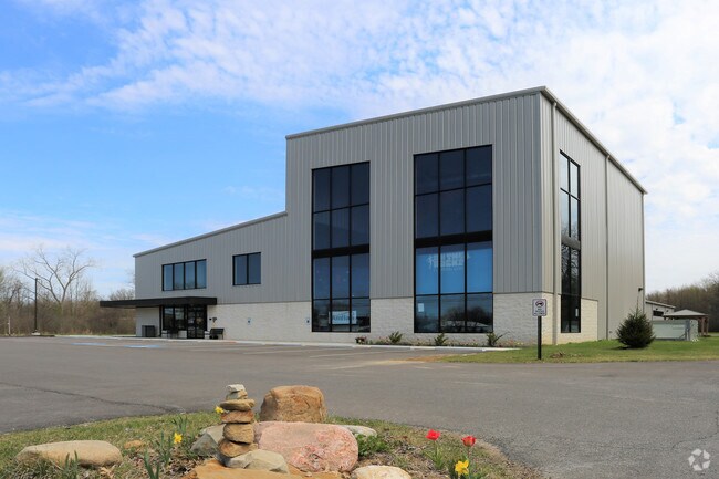

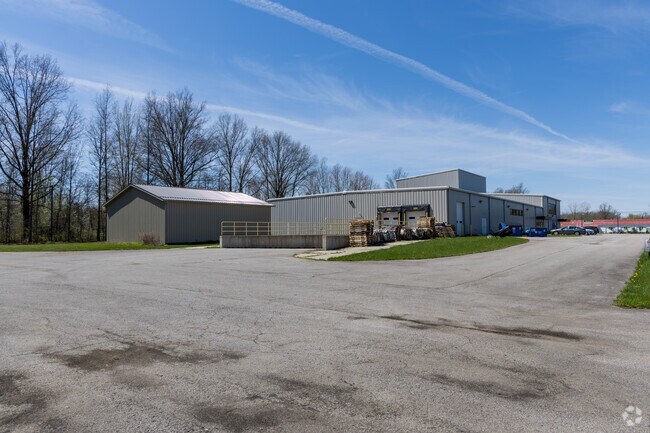
Property Detail
8701 Leavitt Rd
05-00-048-000-075
Lorain
Warehouse
Ohio
B and X Area of moderate flood hazard, usually the area between the limits of the 100-year and 500-year floods.
3.66 AC
2024
Lorain County
2024
Cleveland
057100
Cleveland-Elyria, OH
17,900 SF
NEARBY LISTINGS FOR SALE OR LEASE
-
-
View all Elyria listings for sale on LoopNet.com
DEMOGRAPHICS near 8701 Leavitt Rd
1 mile
3 mile
5 mile
2025 Total Population
410
17,946
58,181
2030 Population
423
18,291
59,636
Pop Growth 2025-2030
+ 3.17%
+ 1.92%
+ 2.50%
Average Age
46
44
43
2025 Total Households
169
7,583
23,976
HH Growth 2025-2030
+ 2.96%
+ 2.02%
+ 2.61%
Median Household Inc
$72,374
$87,879
$74,898
Avg Household Size
2.40
2.30
2.30
2025 Avg HH Vehicles
2.00
2.00
2.00
Median Home Value
$263,749
$231,867
$201,891
Median Year Built
1971
1974
1973
Nearby Places
Map Layers
Map Styles
 Street
 Aerial
Transit
 Traffic
 Biking
Places
Listings with unknown addresses are not visible on the map
- Restaurants
- Banks
- Shops
- Fitness
- Groceries
PUBLIC TRANSPORTATION
COMMUTER RAIL
Drive
Walk
Distance
13 min
7.6 mi
AIRPORT
Cleveland-Hopkins International
Drive
Walk
Distance
Cleveland-Hopkins International
32 min
22.4 mi
Nearby Properties
Address
Land Use
TOTAL SIZE
Lot Size
Zoning
Address
Land Use
TOTAL SIZE
Lot Size
Zoning
118,624 SF
19.80 AC
Address
Land Use
TOTAL SIZE
Lot Size
Zoning
111,373 SF
9.35 AC
Address
Land Use
TOTAL SIZE
Lot Size
Zoning
36.66 AC
Address
Land Use
TOTAL SIZE
Lot Size
Zoning
31,871 SF
6.90 AC
Address
Land Use
TOTAL SIZE
Lot Size
Zoning
54,831 SF
3.93 AC
Address
Land Use
TOTAL SIZE
Lot Size
Zoning
66,196 SF
7.05 AC
Address
Land Use
TOTAL SIZE
Lot Size
Zoning
57,730 SF
7.35 AC
Address
Land Use
TOTAL SIZE
Lot Size
Zoning
67,408 SF
14.83 AC
Address
Land Use
TOTAL SIZE
Lot Size
Zoning
64,442 SF
7.67 AC
Address
Land Use
TOTAL SIZE
Lot Size
Zoning
22,737 SF
8.58 AC
Address
Land Use
TOTAL SIZE
Lot Size
Zoning
27,756 SF
2.61 AC
Address
Land Use
TOTAL SIZE
Lot Size
Zoning
28,524 SF
5.90 AC
Address
Land Use
TOTAL SIZE
Lot Size
Zoning
30,988 SF
0.33 AC
Address
Land Use
TOTAL SIZE
Lot Size
Zoning
182,568 SF
43.21 AC
Address
Land Use
TOTAL SIZE
Lot Size
Zoning
48,978 SF
6.60 AC
Address
Land Use
TOTAL SIZE
Lot Size
Zoning
11.65 AC
Address
Land Use
TOTAL SIZE
Lot Size
Zoning
26,990 SF
20.02 AC
Address
Land Use
TOTAL SIZE
Lot Size
Zoning
49,570 SF
7.27 AC
Address
Land Use
TOTAL SIZE
Lot Size
Zoning
46,777 SF
3.77 AC
Address
Land Use
TOTAL SIZE
Lot Size
Zoning
23,700 SF
2.21 AC
Address
Land Use
TOTAL SIZE
Lot Size
Zoning
14,776 SF
0.48 AC
Address
Land Use
TOTAL SIZE
Lot Size
Zoning
33,882 SF
3.28 AC
Address
Land Use
TOTAL SIZE
Lot Size
Zoning
16,453 SF
9.77 AC
Address
Land Use
TOTAL SIZE
Lot Size
Zoning
29,240 SF
10.25 AC
Address
Land Use
TOTAL SIZE
Lot Size
Zoning
8,364 SF
1.17 AC
Address
Land Use
TOTAL SIZE
Lot Size
Zoning
8,904 SF
1.48 AC
Address
Land Use
TOTAL SIZE
Lot Size
Zoning
9,240 SF
1.22 AC
Address
Land Use
TOTAL SIZE
Lot Size
Zoning
14,150 SF
2.68 AC
Address
Land Use
TOTAL SIZE
Lot Size
Zoning
5,696 SF
0.61 AC
Address
Land Use
TOTAL SIZE
Lot Size
Zoning
69,004 SF
14.30 AC
The World's #1 Commercial Real Estate Marketplace
Connect with us
© 2026 CoStar Group
The information above has been obtained from sources believed reliable. While we do not doubt its accuracy we have not verified it and make no guarantee, warranty or representation about it. It is your responsibility to independently confirm its accuracy and completeness. Any projections, opinions, assumptions, or estimates used are for example only and do not represent the current or future performance of the property. The value of this transaction to you depends on tax and other factors which should be evaluated by your tax, financial, and legal advisors. You and your advisors should conduct a careful, independent investigation of the property to determine to your satisfaction the suitability of the property for your needs.