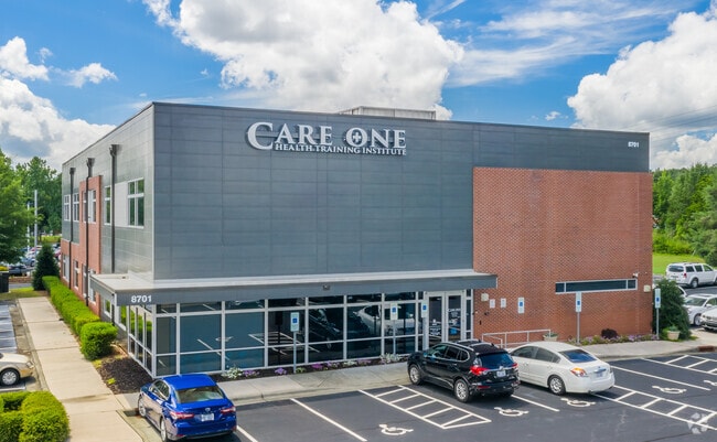
Property Record
8701 Wadford Dr, Raleigh, NC 27616


Current Lease Availabilities
NEARBY LISTINGS FOR SALE OR LEASE
Property Detail
8701 Wadford Dr
Raleigh, NC
Wadford Drive Subdivision
1738.17-00-9515-000
LO4 WADFORD ROAD REVISION PH1 BM2009-010
Publicschool
Wake
X
North Carolina
3720173800K
4
2025
2.54 AC
2025
Route 1
054023
Raleigh/Durham
17,362 SF
DEMOGRAPHICS near 8701 Wadford Dr
1 Mile
3 Mile
5 Mile
2024 Total Population
10,127
73,638
170,375
2029 Population
10,951
80,171
184,974
Pop Growth 2024-2029
+ 8.14%
+ 8.87%
+ 8.57%
Average Age
36
38
39
2024 Total Households
3,702
28,294
66,629
HH Growth 2024-2029
+ 8.18%
+ 8.92%
+ 8.60%
Median Household Inc
$62,094
$84,699
$80,933
Avg Household Size
2.70
2.60
2.50
2024 Avg HH Vehicles
2.00
2.00
2.00
Median Home Value
$252,598
$314,857
$330,224
Median Year Built
2003
2003
1998
Nearby Places
Map Layers
Map Styles
 Street
 Aerial
- Restaurants
- Banks
- Shops
- Fitness
- Groceries
PUBLIC TRANSPORTATION
AIRPORT
Raleigh-Durham International
DRIVE
WALK
Distance
Raleigh-Durham International
24 min
17.6 mi
Freight Ports
Port of Wilmington
DRIVE
WALK
Distance
Port of Wilmington
167 min
141.8 mi
Nearby Properties
Address
Land Use
TOTAL SIZE
Lot Size
Zoning
Address
Land Use
TOTAL SIZE
Lot Size
Zoning
817,723 SF
64.40 AC
OX-5
Address
Land Use
TOTAL SIZE
Lot Size
Zoning
368,475 SF
12.25 AC
CX-4
Address
Land Use
TOTAL SIZE
Lot Size
Zoning
1,125,127 SF
104.26 AC
R-1
Address
Land Use
TOTAL SIZE
Lot Size
Zoning
401,268 SF
23.93 AC
CX-5
Address
Land Use
TOTAL SIZE
Lot Size
Zoning
342,900 SF
19.15 AC
RX-3
Address
Land Use
TOTAL SIZE
Lot Size
Zoning
402,163 SF
23.39 AC
RX-3
Address
Land Use
TOTAL SIZE
Lot Size
Zoning
241,800 SF
14.83 AC
OX-5
Address
Land Use
TOTAL SIZE
Lot Size
Zoning
328,816 SF
17.95 AC
CX-5
Address
Land Use
TOTAL SIZE
Lot Size
Zoning
382,781 SF
52.73 AC
CX-3
Address
Land Use
TOTAL SIZE
Lot Size
Zoning
357,933 SF
16.02 AC
PD
Address
Land Use
TOTAL SIZE
Lot Size
Zoning
306,259 SF
13.35 AC
RX-5
Address
Land Use
TOTAL SIZE
Lot Size
Zoning
285,949 SF
32.91 AC
RX-3
Address
Land Use
TOTAL SIZE
Lot Size
Zoning
298,512 SF
20.16 AC
RX-3
Address
Land Use
TOTAL SIZE
Lot Size
Zoning
317,685 SF
20.15 AC
CUD O
Address
Land Use
TOTAL SIZE
Lot Size
Zoning
299,388 SF
13.83 AC
CX-4
Address
Land Use
TOTAL SIZE
Lot Size
Zoning
251,174 SF
13.98 AC
RX-3
Address
Land Use
TOTAL SIZE
Lot Size
Zoning
684,730 SF
35.37 AC
CX-3
Address
Land Use
TOTAL SIZE
Lot Size
Zoning
217,961 SF
11.77 AC
CX-3
Address
Land Use
TOTAL SIZE
Lot Size
Zoning
454,156 SF
42.41 AC
R-10
Address
Land Use
TOTAL SIZE
Lot Size
Zoning
196,198 SF
29.21 AC
PD
Address
Land Use
TOTAL SIZE
Lot Size
Zoning
307,531 SF
16.73 AC
CX-4
Address
Land Use
TOTAL SIZE
Lot Size
Zoning
201,826 SF
13.79 AC
CX-4
Address
Land Use
TOTAL SIZE
Lot Size
Zoning
310,757 SF
38.38 AC
R-10
Address
Land Use
TOTAL SIZE
Lot Size
Zoning
306,561 SF
27.56 AC
CX-4
Address
Land Use
TOTAL SIZE
Lot Size
Zoning
211,372 SF
38.26 AC
R-4
Address
Land Use
TOTAL SIZE
Lot Size
Zoning
274,175 SF
12.74 AC
CX-5
Address
Land Use
TOTAL SIZE
Lot Size
Zoning
245,352 SF
28.53 AC
R-10
Address
Land Use
TOTAL SIZE
Lot Size
Zoning
270,618 SF
30.39 AC
R-10
Address
Land Use
TOTAL SIZE
Lot Size
Zoning
77,921 SF
33 AC
IX-3
Address
Land Use
TOTAL SIZE
Lot Size
Zoning
155,079 SF
5.87 AC
PD
The World's #1 Commercial Real Estate Marketplace
Connect with us
© 2026 CoStar Group
The information above has been obtained from sources believed reliable. While we do not doubt its accuracy we have not verified it and make no guarantee, warranty or representation about it. It is your responsibility to independently confirm its accuracy and completeness. Any projections, opinions, assumptions, or estimates used are for example only and do not represent the current or future performance of the property. The value of this transaction to you depends on tax and other factors which should be evaluated by your tax, financial, and legal advisors. You and your advisors should conduct a careful, independent investigation of the property to determine to your satisfaction the suitability of the property for your needs.