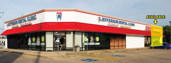
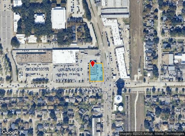
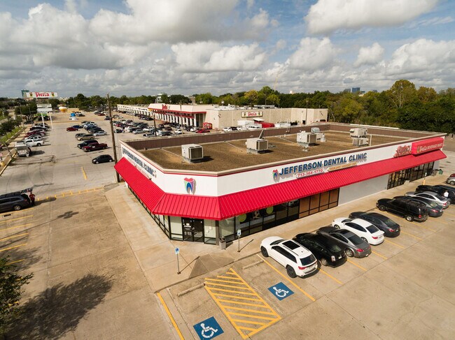
Property Record
8702 Bellaire Blvd, Houston, TX 77036
NEARBY LISTINGS FOR SALE OR LEASE
Property Detail
8702 Bellaire Blvd
0915190000002
Sharpstown Acreage
Storebuilding
TR 15A SHARPSTOWN ACREAGE
AE
Harris
48157C0175L
Texas
2024
0.67 AC
2025
Southwest
433007
Houston
9,890 SF
Houston-The Woodlands-Sugar Land, TX
DEMOGRAPHICS near 8702 Bellaire Blvd
1 Mile
3 Mile
5 Mile
2024 Total Population
32,478
247,940
599,450
2029 Population
32,978
253,995
615,476
Pop Growth 2024-2029
+ 1.54%
+ 2.44%
+ 2.67%
Average Age
36
35
36
2024 Total Households
11,583
94,983
232,531
HH Growth 2024-2029
+ 1.51%
+ 2.40%
+ 2.69%
Median Household Inc
$39,402
$38,677
$47,535
Avg Household Size
2.70
2.50
2.50
2024 Avg HH Vehicles
1.00
1.00
2.00
Median Home Value
$222,639
$189,718
$268,972
Median Year Built
1976
1978
1978
Nearby Places
Map Layers
Map Styles
 Street
 Aerial
- Restaurants
- Banks
- Shops
- Fitness
- Groceries
PUBLIC TRANSPORTATION
AIRPORT
William P Hobby
DRIVE
WALK
Distance
William P Hobby
38 min
23.0 mi
George Bush Intcntl/Houston
DRIVE
WALK
Distance
George Bush Intcntl/Houston
41 min
33.6 mi
Freight Ports
Port of Houston
DRIVE
WALK
Distance
Port of Houston
35 min
22.4 mi
SALE & LEASE HISTORY
LISTING DATE
SALE/LEASE

Sep 15, 2023
For Lease
Oct 27, 2017
For Lease
Nearby Properties
Address
Land Use
TOTAL SIZE
Lot Size
Zoning
Address
Land Use
TOTAL SIZE
Lot Size
Zoning
2,198,376 SF
14.18 AC
Address
Land Use
TOTAL SIZE
Lot Size
Zoning
1,020,766 SF
3.08 AC
Address
Land Use
TOTAL SIZE
Lot Size
Zoning
1,082,545 SF
7.22 AC
Address
Land Use
TOTAL SIZE
Lot Size
Zoning
878,129 SF
11.69 AC
Address
Land Use
TOTAL SIZE
Lot Size
Zoning
1,172,310 SF
8.17 AC
Address
Land Use
TOTAL SIZE
Lot Size
Zoning
967,728 SF
7.40 AC
Address
Land Use
TOTAL SIZE
Lot Size
Zoning
511,262 SF
6.60 AC
Address
Land Use
TOTAL SIZE
Lot Size
Zoning
972,984 SF
30.18 AC
Address
Land Use
TOTAL SIZE
Lot Size
Zoning
361,954 SF
14.43 AC
Address
Land Use
TOTAL SIZE
Lot Size
Zoning
627,632 SF
24.12 AC
Address
Land Use
TOTAL SIZE
Lot Size
Zoning
413,734 SF
6.22 AC
Address
Land Use
TOTAL SIZE
Lot Size
Zoning
380,423 SF
15.14 AC
Address
Land Use
TOTAL SIZE
Lot Size
Zoning
188,178 SF
18.49 AC
Address
Land Use
TOTAL SIZE
Lot Size
Zoning
769,005 SF
20.46 AC
Address
Land Use
TOTAL SIZE
Lot Size
Zoning
771,720 SF
19.28 AC
Address
Land Use
TOTAL SIZE
Lot Size
Zoning
383,540 SF
4.43 AC
Address
Land Use
TOTAL SIZE
Lot Size
Zoning
598,127 SF
4.14 AC
Address
Land Use
TOTAL SIZE
Lot Size
Zoning
340,136 SF
13.34 AC
Address
Land Use
TOTAL SIZE
Lot Size
Zoning
362,473 SF
15.65 AC
Address
Land Use
TOTAL SIZE
Lot Size
Zoning
539,308 SF
21 AC
Address
Land Use
TOTAL SIZE
Lot Size
Zoning
997,813 SF
5.25 AC
Address
Land Use
TOTAL SIZE
Lot Size
Zoning
409,371 SF
8.67 AC
Address
Land Use
TOTAL SIZE
Lot Size
Zoning
351,042 SF
5 AC
Address
Land Use
TOTAL SIZE
Lot Size
Zoning
496,395 SF
8.46 AC
Address
Land Use
TOTAL SIZE
Lot Size
Zoning
376,860 SF
12.42 AC
Address
Land Use
TOTAL SIZE
Lot Size
Zoning
643,125 SF
7.92 AC
Address
Land Use
TOTAL SIZE
Lot Size
Zoning
354,203 SF
3.29 AC
Address
Land Use
TOTAL SIZE
Lot Size
Zoning
493,494 SF
13.54 AC
Address
Land Use
TOTAL SIZE
Lot Size
Zoning
700,828 SF
3.82 AC
Address
Land Use
TOTAL SIZE
Lot Size
Zoning
379,078 SF
14.83 AC
The World's #1 Commercial Real Estate Marketplace
Connect with us
© 2025 CoStar Group
The information above has been obtained from sources believed reliable. While we do not doubt its accuracy we have not verified it and make no guarantee, warranty or representation about it. It is your responsibility to independently confirm its accuracy and completeness. Any projections, opinions, assumptions, or estimates used are for example only and do not represent the current or future performance of the property. The value of this transaction to you depends on tax and other factors which should be evaluated by your tax, financial, and legal advisors. You and your advisors should conduct a careful, independent investigation of the property to determine to your satisfaction the suitability of the property for your needs.