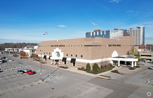
Property Record
8702 Keystone Xing, Indianapolis, IN 46240
NEARBY LISTINGS FOR SALE OR LEASE
Property Detail
8702 Keystone Xing
49-02-18-112-009.000-800
PT SE1/4 S18 T17 R4 BEG 322.83E 1223.49N 819.61WSE COR; W748.10 SW405.85 S492.52 E566.727 NERLY134.75 E120.75 N174.21 NW50.99 N153 NE50.99 N380BEG(15.563AC)EX...N27.18 W7 TO BEG(1.58AC)13.983AC
Regionalshoppingcenterormallwithanchorstore
Marion
X
Indiana
18097C0061F
13.98 AC
2024
Keystone Crossing
2024
Indianapolis
320205
Indianapolis-Carmel-Anderson, IN
DEMOGRAPHICS near 8702 Keystone Xing
1 Mile
3 Mile
5 Mile
2024 Total Population
3,855
56,147
179,879
2029 Population
3,842
57,491
185,745
Pop Growth 2024-2029
(0.34%)
+ 2.39%
+ 3.26%
Average Age
43
41
40
2024 Total Households
2,124
26,468
82,915
HH Growth 2024-2029
(0.38%)
+ 1.90%
+ 2.99%
Median Household Inc
$79,138
$79,464
$78,761
Avg Household Size
1.70
2.10
2.10
2024 Avg HH Vehicles
1.00
2.00
2.00
Median Home Value
$305,238
$310,941
$291,623
Median Year Built
1988
1978
1979
Nearby Places
Map Layers
Map Styles
 Street
 Aerial
- Restaurants
- Banks
- Shops
- Fitness
- Groceries
PUBLIC TRANSPORTATION
AIRPORT
Indianapolis International
DRIVE
WALK
Distance
Indianapolis International
48 min
25.9 mi
Freight Ports
Port of Toledo
DRIVE
WALK
Distance
Port of Toledo
260 min
216.9 mi
SALE & LEASE HISTORY
LISTING DATE
SALE/LEASE

Sep 25, 2016
For Lease
Nearby Properties
Address
Land Use
TOTAL SIZE
Lot Size
Zoning
Address
Land Use
TOTAL SIZE
Lot Size
Zoning
21,742 SF
39.35 AC
ZO01
Address
Land Use
TOTAL SIZE
Lot Size
Zoning
8,551 SF
45.92 AC
ZO01
Address
Land Use
TOTAL SIZE
Lot Size
Zoning
16,704 SF
109.83 AC
ZO01
Address
Land Use
TOTAL SIZE
Lot Size
Zoning
4,146 SF
45.91 AC
ZO01
Address
Land Use
TOTAL SIZE
Lot Size
Zoning
315,968 SF
0.06 AC
ZO01
Address
Land Use
TOTAL SIZE
Lot Size
Zoning
408,298 SF
15.67 AC
Address
Land Use
TOTAL SIZE
Lot Size
Zoning
317,335 SF
4.22 AC
Address
Land Use
TOTAL SIZE
Lot Size
Zoning
117,212 SF
2.81 AC
Address
Land Use
TOTAL SIZE
Lot Size
Zoning
3,053 SF
10.33 AC
ZO01
Address
Land Use
TOTAL SIZE
Lot Size
Zoning
428,056 SF
20.27 AC
Address
Land Use
TOTAL SIZE
Lot Size
Zoning
345 SF
6.39 AC
ZO01
Address
Land Use
TOTAL SIZE
Lot Size
Zoning
5,314 SF
13.92 AC
ZO01
Address
Land Use
TOTAL SIZE
Lot Size
Zoning
107,078 SF
15.66 AC
ZO01
Address
Land Use
TOTAL SIZE
Lot Size
Zoning
290,488 SF
13.72 AC
Address
Land Use
TOTAL SIZE
Lot Size
Zoning
8,157 SF
113.93 AC
ZO01
Address
Land Use
TOTAL SIZE
Lot Size
Zoning
6,252 SF
52.04 AC
ZO01
Address
Land Use
TOTAL SIZE
Lot Size
Zoning
288 SF
7.35 AC
ZO01
Address
Land Use
TOTAL SIZE
Lot Size
Zoning
158,839 SF
0.06 AC
Address
Land Use
TOTAL SIZE
Lot Size
Zoning
1,904 SF
67.93 AC
ZO01
Address
Land Use
TOTAL SIZE
Lot Size
Zoning
6,229 SF
36.20 AC
ZO01
Address
Land Use
TOTAL SIZE
Lot Size
Zoning
3,316 SF
8.91 AC
ZO01
Address
Land Use
TOTAL SIZE
Lot Size
Zoning
229,554 SF
11.78 AC
ZO01
Address
Land Use
TOTAL SIZE
Lot Size
Zoning
235,807 SF
12.92 AC
Address
Land Use
TOTAL SIZE
Lot Size
Zoning
285,284 SF
7.78 AC
Address
Land Use
TOTAL SIZE
Lot Size
Zoning
10,514 SF
15.75 AC
ZO01
Address
Land Use
TOTAL SIZE
Lot Size
Zoning
1,700 SF
33.14 AC
ZO01
Address
Land Use
TOTAL SIZE
Lot Size
Zoning
5,149 SF
10.56 AC
ZO01
Address
Land Use
TOTAL SIZE
Lot Size
Zoning
127,922 SF
3.35 AC
ZO01
Address
Land Use
TOTAL SIZE
Lot Size
Zoning
50,698 SF
13.58 AC
Address
Land Use
TOTAL SIZE
Lot Size
Zoning
182,869 SF
7 AC
ZO01
The World's #1 Commercial Real Estate Marketplace
Connect with us
© 2025 CoStar Group
The information above has been obtained from sources believed reliable. While we do not doubt its accuracy we have not verified it and make no guarantee, warranty or representation about it. It is your responsibility to independently confirm its accuracy and completeness. Any projections, opinions, assumptions, or estimates used are for example only and do not represent the current or future performance of the property. The value of this transaction to you depends on tax and other factors which should be evaluated by your tax, financial, and legal advisors. You and your advisors should conduct a careful, independent investigation of the property to determine to your satisfaction the suitability of the property for your needs.