Property Record
8705 Wards Rd, Rustburg, VA 24588
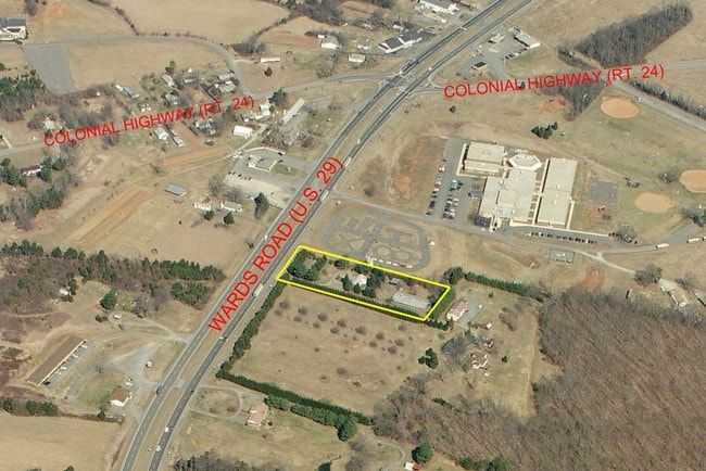
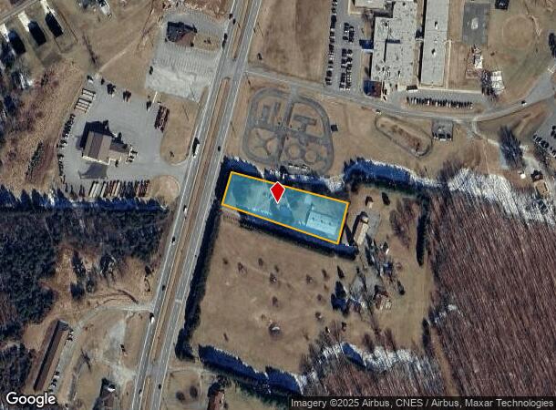
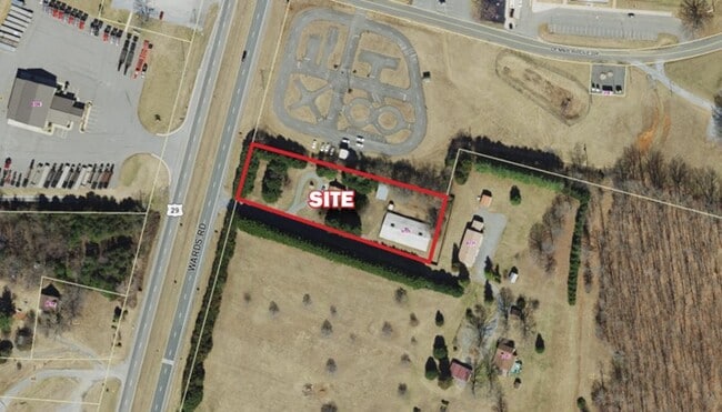
This Property Is For Sale
NEARBY LISTINGS FOR SALE OR LEASE
Property Detail
8705 Wards Rd
43-2-11
PT LOTS 65-68, 134-137 - SWEENEY
Commercialnec
Campbell
X
Virginia
51019C0400D
65-68
2025
1.34 AC
2025
Lynchburg
020500
Other Market Areas
1,320 SF
Lynchburg, VA
DEMOGRAPHICS near 8705 Wards Rd
1 Mile
3 Mile
5 Mile
2024 Total Population
444
4,096
12,879
2029 Population
437
4,034
12,808
Pop Growth 2024-2029
(1.58%)
(1.51%)
(0.55%)
Average Age
43
44
41
2024 Total Households
183
1,724
4,978
HH Growth 2024-2029
(1.64%)
(1.45%)
(0.56%)
Median Household Inc
$54,411
$50,034
$54,227
Avg Household Size
2.40
2.40
2.40
2024 Avg HH Vehicles
2.00
2.00
2.00
Median Home Value
$165,217
$149,873
$179,416
Median Year Built
1982
1984
1986
Nearby Places
Map Layers
Map Styles
 Street
 Aerial
- Restaurants
- Banks
- Shops
- Fitness
- Groceries
PUBLIC TRANSPORTATION
AIRPORT
Lynchburg Regional/Preston Glenn Field
DRIVE
WALK
Distance
Lynchburg Regional/Preston Glenn Field
14 min
7.8 mi
Freight Ports
Virginia Port Authority - Richmond
DRIVE
WALK
Distance
Virginia Port Authority - Richmond
161 min
114.1 mi
Nearby Properties
Address
Land Use
TOTAL SIZE
Lot Size
Zoning
Address
Land Use
TOTAL SIZE
Lot Size
Zoning
35,811 SF
12.19 AC
BGC
Address
Land Use
TOTAL SIZE
Lot Size
Zoning
71,400 SF
46.21 AC
Address
Land Use
TOTAL SIZE
Lot Size
Zoning
20,000 SF
44.36 AC
IGC
Address
Land Use
TOTAL SIZE
Lot Size
Zoning
20,250 SF
3.29 AC
Address
Land Use
TOTAL SIZE
Lot Size
Zoning
2,400 SF
26.60 AC
IH
Address
Land Use
TOTAL SIZE
Lot Size
Zoning
4,604 SF
2.81 AC
BGC
Address
Land Use
TOTAL SIZE
Lot Size
Zoning
21,780 SF
4.17 AC
BGC
Address
Land Use
TOTAL SIZE
Lot Size
Zoning
9,540 SF
6.66 AC
IH
Address
Land Use
TOTAL SIZE
Lot Size
Zoning
5,153 SF
2.36 AC
BGC
Address
Land Use
TOTAL SIZE
Lot Size
Zoning
6,850 SF
2.19 AC
BGC
Address
Land Use
TOTAL SIZE
Lot Size
Zoning
2,140 SF
9.70 AC
Address
Land Use
TOTAL SIZE
Lot Size
Zoning
8,753 SF
3.15 AC
BGC
Address
Land Use
TOTAL SIZE
Lot Size
Zoning
4,215 SF
3.16 AC
BGC
Address
Land Use
TOTAL SIZE
Lot Size
Zoning
10,000 SF
5.20 AC
IH
Address
Land Use
TOTAL SIZE
Lot Size
Zoning
320 SF
3.41 AC
BGC
Address
Land Use
TOTAL SIZE
Lot Size
Zoning
1,280 SF
0.92 AC
BHC
Address
Land Use
TOTAL SIZE
Lot Size
Zoning
4,317 SF
1.45 AC
BGC
Address
Land Use
TOTAL SIZE
Lot Size
Zoning
3,020 SF
231.41 AC
A1
Address
Land Use
TOTAL SIZE
Lot Size
Zoning
1,400 SF
461.47 AC
Address
Land Use
TOTAL SIZE
Lot Size
Zoning
8,040 SF
5.84 AC
IG
Address
Land Use
TOTAL SIZE
Lot Size
Zoning
12,000 SF
8 AC
IG
Address
Land Use
TOTAL SIZE
Lot Size
Zoning
7,284 SF
9.91 AC
BGC
Address
Land Use
TOTAL SIZE
Lot Size
Zoning
11,250 SF
5.85 AC
Address
Land Use
TOTAL SIZE
Lot Size
Zoning
12,640 SF
4.40 AC
BGC
Address
Land Use
TOTAL SIZE
Lot Size
Zoning
4,750 SF
1.96 AC
BGC
Address
Land Use
TOTAL SIZE
Lot Size
Zoning
9,200 SF
5.47 AC
IGC
Address
Land Use
TOTAL SIZE
Lot Size
Zoning
4,500 SF
4.53 AC
IGC
Address
Land Use
TOTAL SIZE
Lot Size
Zoning
4,596 SF
8 AC
Address
Land Use
TOTAL SIZE
Lot Size
Zoning
6,000 SF
9.60 AC
A1
Address
Land Use
TOTAL SIZE
Lot Size
Zoning
7,561 SF
8.87 AC
BHC
The World's #1 Commercial Real Estate Marketplace
Connect with us
© 2026 CoStar Group
The information above has been obtained from sources believed reliable. While we do not doubt its accuracy we have not verified it and make no guarantee, warranty or representation about it. It is your responsibility to independently confirm its accuracy and completeness. Any projections, opinions, assumptions, or estimates used are for example only and do not represent the current or future performance of the property. The value of this transaction to you depends on tax and other factors which should be evaluated by your tax, financial, and legal advisors. You and your advisors should conduct a careful, independent investigation of the property to determine to your satisfaction the suitability of the property for your needs.