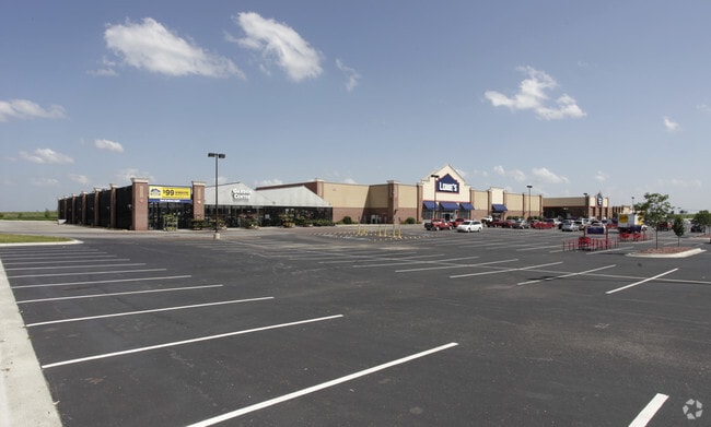
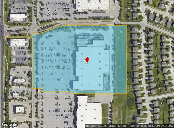
Property Record
8707 S 71St Plz, Papillion, NE 68133
NEARBY LISTINGS FOR SALE OR LEASE
Property Detail
8707 S 71St Plz
Omaha-Council Bluffs, NE-IA
Market Pointe Addition
011583018
LOT 2 (ALLA) MARKET POINTE ADDITION (15.40 AC)
Commercialnec
Sarpy
X
Nebraska
31153C0070H
2
2024
2.04 AC
2025
Sarpy East
010637
Omaha/Council Bluffs
139,009 SF
DEMOGRAPHICS near 8707 S 71St Plz
1 Mile
3 Mile
5 Mile
2024 Total Population
11,070
78,270
192,923
2029 Population
11,840
82,800
202,030
Pop Growth 2024-2029
+ 6.96%
+ 5.79%
+ 4.72%
Average Age
38
39
37
2024 Total Households
3,890
30,681
73,802
HH Growth 2024-2029
+ 7.17%
+ 5.83%
+ 4.74%
Median Household Inc
$100,905
$73,149
$69,941
Avg Household Size
2.80
2.50
2.50
2024 Avg HH Vehicles
2.00
2.00
2.00
Median Home Value
$252,924
$233,560
$220,026
Median Year Built
1992
1984
1979
Nearby Places
Map Layers
Map Styles
 Street
 Aerial
- Restaurants
- Banks
- Shops
- Fitness
- Groceries
PUBLIC TRANSPORTATION
AIRPORT
Eppley Airfield
DRIVE
WALK
Distance
Eppley Airfield
26 min
14.1 mi
Freight Ports
Tulsa Port Of Catoosa
DRIVE
WALK
Distance
Tulsa Port Of Catoosa
463 min
416.4 mi
Nearby Properties
Address
Land Use
TOTAL SIZE
Lot Size
Zoning
Address
Land Use
TOTAL SIZE
Lot Size
Zoning
483,925 SF
42.06 AC
Address
Land Use
TOTAL SIZE
Lot Size
Zoning
28,401 SF
27.31 AC
Address
Land Use
TOTAL SIZE
Lot Size
Zoning
25,204 SF
2.34 AC
R4
Address
Land Use
TOTAL SIZE
Lot Size
Zoning
28,820 SF
16.81 AC
Address
Land Use
TOTAL SIZE
Lot Size
Zoning
341,667 SF
24.15 AC
Address
Land Use
TOTAL SIZE
Lot Size
Zoning
3,906 SF
13.62 AC
RG20
Address
Land Use
TOTAL SIZE
Lot Size
Zoning
28,913 SF
2.04 AC
Address
Land Use
TOTAL SIZE
Lot Size
Zoning
294,672 SF
15.06 AC
Address
Land Use
TOTAL SIZE
Lot Size
Zoning
18,727 SF
11.15 AC
RG20
Address
Land Use
TOTAL SIZE
Lot Size
Zoning
13,930 SF
1.04 AC
Address
Land Use
TOTAL SIZE
Lot Size
Zoning
199,152 SF
13.44 AC
R6
Address
Land Use
TOTAL SIZE
Lot Size
Zoning
271,344 SF
9.78 AC
Address
Land Use
TOTAL SIZE
Lot Size
Zoning
271,404 SF
17.51 AC
Address
Land Use
TOTAL SIZE
Lot Size
Zoning
309,162 SF
15.54 AC
Address
Land Use
TOTAL SIZE
Lot Size
Zoning
88,545 SF
9.58 AC
Address
Land Use
TOTAL SIZE
Lot Size
Zoning
97,617 SF
49.05 AC
Address
Land Use
TOTAL SIZE
Lot Size
Zoning
2,610 SF
9.96 AC
Address
Land Use
TOTAL SIZE
Lot Size
Zoning
37,196 SF
13.96 AC
MU
Address
Land Use
TOTAL SIZE
Lot Size
Zoning
18,484 SF
5.47 AC
Address
Land Use
TOTAL SIZE
Lot Size
Zoning
11,244 SF
6.91 AC
Address
Land Use
TOTAL SIZE
Lot Size
Zoning
217,511 SF
25.06 AC
Address
Land Use
TOTAL SIZE
Lot Size
Zoning
149,713 SF
10.46 AC
Address
Land Use
TOTAL SIZE
Lot Size
Zoning
11,889 SF
5.58 AC
Address
Land Use
TOTAL SIZE
Lot Size
Zoning
196,746 SF
10.22 AC
Address
Land Use
TOTAL SIZE
Lot Size
Zoning
172,272 SF
7.48 AC
R6
Address
Land Use
TOTAL SIZE
Lot Size
Zoning
6,472 SF
4.58 AC
Address
Land Use
TOTAL SIZE
Lot Size
Zoning
170,665 SF
10.94 AC
Address
Land Use
TOTAL SIZE
Lot Size
Zoning
130,245 SF
6.93 AC
Address
Land Use
TOTAL SIZE
Lot Size
Zoning
7,448 SF
4.71 AC
Address
Land Use
TOTAL SIZE
Lot Size
Zoning
7,448 SF
2.89 AC
The World's #1 Commercial Real Estate Marketplace
Connect with us
© 2026 CoStar Group
The information above has been obtained from sources believed reliable. While we do not doubt its accuracy we have not verified it and make no guarantee, warranty or representation about it. It is your responsibility to independently confirm its accuracy and completeness. Any projections, opinions, assumptions, or estimates used are for example only and do not represent the current or future performance of the property. The value of this transaction to you depends on tax and other factors which should be evaluated by your tax, financial, and legal advisors. You and your advisors should conduct a careful, independent investigation of the property to determine to your satisfaction the suitability of the property for your needs.