Property Record
Main St, Whitmore Lake, MI 48189
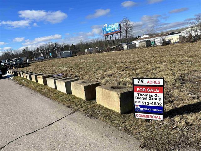
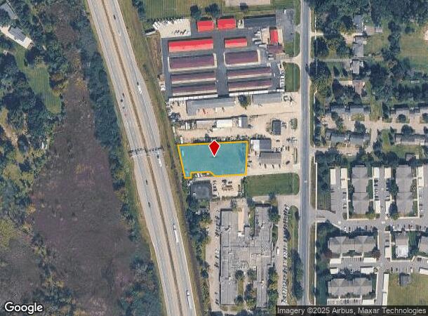
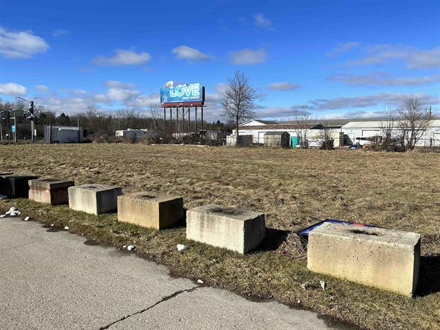

This Property Is For Sale
NEARBY LISTINGS FOR SALE OR LEASE
Property Detail
Main St
02-08-250-021
OWNER REQUEST NO 8-9Q-1B COM AT NW COR SEC 8 TH N 87-55-02 E 652.80 FT, TH S 00-31-40 W 1837.21 FT, TH S 85-21-40 W 193.48 FT
Commercialacreage
Washtenaw
X
Michigan
26161C0092E
0.79 AC
2025
Washtenaw E of 23
2025
Detroit
465001
Ann Arbor, MI
DEMOGRAPHICS near Main St
1 Mile
3 Mile
5 Mile
2024 Total Population
3,579
12,176
27,804
2029 Population
3,533
12,243
28,177
Pop Growth 2024-2029
(1.29%)
+ 0.55%
+ 1.34%
Average Age
40
42
43
2024 Total Households
1,525
4,894
10,924
HH Growth 2024-2029
(1.31%)
+ 0.49%
+ 1.30%
Median Household Inc
$86,585
$78,421
$93,010
Avg Household Size
2.30
2.40
2.50
2024 Avg HH Vehicles
2.00
2.00
2.00
Median Home Value
$260,056
$291,205
$333,879
Median Year Built
1991
1989
1989
Nearby Places
- Restaurants
- Banks
- Shops
- Fitness
- Groceries
PUBLIC TRANSPORTATION
COMMUTER RAIL
Ann Arbor Amtrak Station (Wolverine - Amtrak)
DRIVE
WALK
Distance
Ann Arbor Amtrak Station (Wolverine - Amtrak)
14 min
9.4 mi
AIRPORT
Detroit Metro Wayne County
DRIVE
WALK
Distance
Detroit Metro Wayne County
46 min
36.8 mi
Freight Ports
Port of Toledo
DRIVE
WALK
Distance
Port of Toledo
88 min
69.8 mi
Nearby Properties
Address
Land Use
TOTAL SIZE
Lot Size
Zoning
Address
Land Use
TOTAL SIZE
Lot Size
Zoning
301,472 SF
72.80 AC
LI
Address
Land Use
TOTAL SIZE
Lot Size
Zoning
291,012 SF
70.69 AC
P.U.D
Address
Land Use
TOTAL SIZE
Lot Size
Zoning
291,012 SF
Address
Land Use
TOTAL SIZE
Lot Size
Zoning
301,472 SF
62.80 AC
LI
Address
Land Use
TOTAL SIZE
Lot Size
Zoning
893 SF
130.95 AC
MHP-MOBIL
Address
Land Use
TOTAL SIZE
Lot Size
Zoning
32,964 SF
11.95 AC
MR-MULTIPL
Address
Land Use
TOTAL SIZE
Lot Size
Zoning
10,839 SF
9.52 AC
MR-MULTIPL
Address
Land Use
TOTAL SIZE
Lot Size
Zoning
101,120 SF
12.30 AC
RM
Address
Land Use
TOTAL SIZE
Lot Size
Zoning
1,970 SF
37.72 AC
MHP
Address
Land Use
TOTAL SIZE
Lot Size
Zoning
12,000 SF
26.97 AC
GI-GEN IND
Address
Land Use
TOTAL SIZE
Lot Size
Zoning
103,900 SF
26.88 AC
GI
Address
Land Use
TOTAL SIZE
Lot Size
Zoning
62,548 SF
4.28 AC
GC-GEN COM
Address
Land Use
TOTAL SIZE
Lot Size
Zoning
50 AC
MHP
Address
Land Use
TOTAL SIZE
Lot Size
Zoning
41.13 AC
GC-GEN COM
Address
Land Use
TOTAL SIZE
Lot Size
Zoning
65.46 AC
GC-GEN COM
Address
Land Use
TOTAL SIZE
Lot Size
Zoning
17.83 AC
HC
Address
Land Use
TOTAL SIZE
Lot Size
Zoning
50,733 SF
12.51 AC
RTM-RESEAR
Address
Land Use
TOTAL SIZE
Lot Size
Zoning
70.16 AC
PSC-PLANNE
Address
Land Use
TOTAL SIZE
Lot Size
Zoning
73,711 SF
6.77 AC
LI
Address
Land Use
TOTAL SIZE
Lot Size
Zoning
29,190 SF
19.97 AC
RTM-RESEAR
Address
Land Use
TOTAL SIZE
Lot Size
Zoning
46,647 SF
7.16 AC
GB
Address
Land Use
TOTAL SIZE
Lot Size
Zoning
49,834 SF
8 AC
RTM-RESEAR
Address
Land Use
TOTAL SIZE
Lot Size
Zoning
35,119 SF
RTM-RESEAR
Address
Land Use
TOTAL SIZE
Lot Size
Zoning
35.74 AC
GC-GEN COM
Address
Land Use
TOTAL SIZE
Lot Size
Zoning
47,088 SF
7.72 AC
RM
Address
Land Use
TOTAL SIZE
Lot Size
Zoning
52,100 SF
10.36 AC
GI
Address
Land Use
TOTAL SIZE
Lot Size
Zoning
22,676 SF
5.30 AC
GC-GEN COM
Address
Land Use
TOTAL SIZE
Lot Size
Zoning
24,500 SF
12.15 AC
GI
Address
Land Use
TOTAL SIZE
Lot Size
Zoning
12,942 SF
1.52 AC
VC
Address
Land Use
TOTAL SIZE
Lot Size
Zoning
3,800 SF
5.53 AC
GC-GEN COM
The World's #1 Commercial Real Estate Marketplace
Connect with us
© 2025 CoStar Group
The information above has been obtained from sources believed reliable. While we do not doubt its accuracy we have not verified it and make no guarantee, warranty or representation about it. It is your responsibility to independently confirm its accuracy and completeness. Any projections, opinions, assumptions, or estimates used are for example only and do not represent the current or future performance of the property. The value of this transaction to you depends on tax and other factors which should be evaluated by your tax, financial, and legal advisors. You and your advisors should conduct a careful, independent investigation of the property to determine to your satisfaction the suitability of the property for your needs.