Property Record
8709 N Interstate 35, Austin, TX 78753
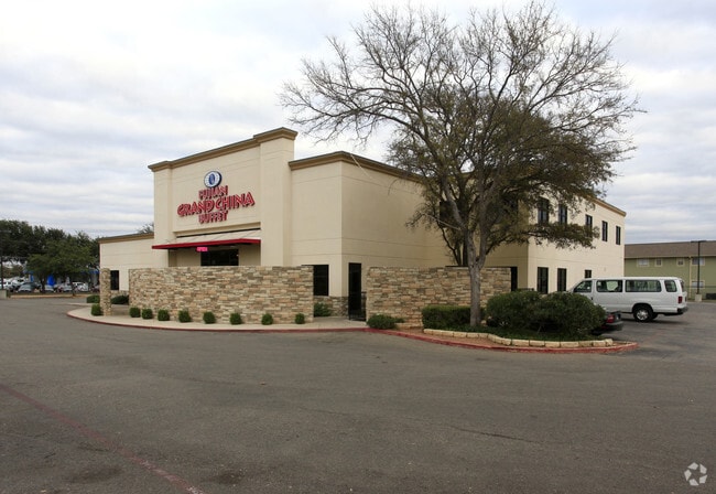


Property Detail
8709 N Interstate 35
Austin-Round Rock-San Marcos, TX
1.8868AC OF LOT 1 OLD SAN FRANCISCO ADDN
239726
Travis
Restaurantbuilding
Texas
AE The base floodplain where base flood elevations are provided. AE Zones are now used on new format FIRMs instead of A1-A30 Zones.
1
2025
1.89 AC
2025
Northeast
040300
Austin
12,755 SF
NEARBY LISTINGS FOR SALE OR LEASE
DEMOGRAPHICS near 8709 N Interstate 35
1 mile
3 mile
5 mile
2025 Total Population
23,552
147,421
342,726
2030 Population
24,521
154,806
359,839
Pop Growth 2025-2030
+ 4.11%
+ 5.01%
+ 4.99%
Average Age
35
37
37
2025 Total Households
8,725
60,961
150,484
HH Growth 2025-2030
+ 4.87%
+ 5.87%
+ 5.68%
Median Household Inc
$50,710
$72,898
$81,477
Avg Household Size
2.60
2.30
2.20
2025 Avg HH Vehicles
2.00
2.00
2.00
Median Home Value
$375,484
$515,899
$597,672
Median Year Built
1984
1983
1988
Nearby Places
Map Layers
Map Styles
 Street
 Aerial
Transit
 Traffic
 Biking
Places
Listings with unknown addresses are not visible on the map
- Restaurants
- Banks
- Shops
- Fitness
- Groceries
PUBLIC TRANSPORTATION
COMMUTER RAIL
Austin (Texas Eagle - Amtrak)
Drive
Walk
Distance
Austin (Texas Eagle - Amtrak)
15 min
9.3 mi
AIRPORT
Austin-Bergstrom International
Drive
Walk
Distance
Austin-Bergstrom International
29 min
18.1 mi
Freight Ports
Calhoun Port
Drive
Walk
Distance
Calhoun Port
194 min
161.6 mi
Nearby Properties
Address
Land Use
TOTAL SIZE
Lot Size
Zoning
Address
Land Use
TOTAL SIZE
Lot Size
Zoning
480,823 SF
18.46 AC
Address
Land Use
TOTAL SIZE
Lot Size
Zoning
372,075 SF
4.97 AC
Address
Land Use
TOTAL SIZE
Lot Size
Zoning
346,319 SF
6.53 AC
Address
Land Use
TOTAL SIZE
Lot Size
Zoning
425,200 SF
2.49 AC
Address
Land Use
TOTAL SIZE
Lot Size
Zoning
286,276 SF
4.53 AC
Address
Land Use
TOTAL SIZE
Lot Size
Zoning
274,228 SF
4.95 AC
Address
Land Use
TOTAL SIZE
Lot Size
Zoning
276,772 SF
4.68 AC
Address
Land Use
TOTAL SIZE
Lot Size
Zoning
467,647 SF
3.54 AC
Address
Land Use
TOTAL SIZE
Lot Size
Zoning
299,957 SF
22.02 AC
Address
Land Use
TOTAL SIZE
Lot Size
Zoning
18.45 AC
Address
Land Use
TOTAL SIZE
Lot Size
Zoning
521,820 SF
4.68 AC
Address
Land Use
TOTAL SIZE
Lot Size
Zoning
248,325 SF
2.46 AC
Address
Land Use
TOTAL SIZE
Lot Size
Zoning
267,091 SF
3.90 AC
Address
Land Use
TOTAL SIZE
Lot Size
Zoning
263,177 SF
4.65 AC
Address
Land Use
TOTAL SIZE
Lot Size
Zoning
233,475 SF
2.94 AC
Address
Land Use
TOTAL SIZE
Lot Size
Zoning
242,722 SF
2.72 AC
Address
Land Use
TOTAL SIZE
Lot Size
Zoning
278,100 SF
3.55 AC
Address
Land Use
TOTAL SIZE
Lot Size
Zoning
264,401 SF
10.48 AC
Address
Land Use
TOTAL SIZE
Lot Size
Zoning
237,603 SF
8.38 AC
Address
Land Use
TOTAL SIZE
Lot Size
Zoning
252,450 SF
2.72 AC
Address
Land Use
TOTAL SIZE
Lot Size
Zoning
276,841 SF
2.77 AC
Address
Land Use
TOTAL SIZE
Lot Size
Zoning
485,377 SF
3.19 AC
Address
Land Use
TOTAL SIZE
Lot Size
Zoning
254,796 SF
11.29 AC
Address
Land Use
TOTAL SIZE
Lot Size
Zoning
235,476 SF
3.34 AC
Address
Land Use
TOTAL SIZE
Lot Size
Zoning
277,987 SF
11.01 AC
Address
Land Use
TOTAL SIZE
Lot Size
Zoning
267,928 SF
2.50 AC
Address
Land Use
TOTAL SIZE
Lot Size
Zoning
179,670 SF
2.89 AC
Address
Land Use
TOTAL SIZE
Lot Size
Zoning
261,525 SF
4.39 AC
Address
Land Use
TOTAL SIZE
Lot Size
Zoning
246,675 SF
3.41 AC
Address
Land Use
TOTAL SIZE
Lot Size
Zoning
14.20 AC
The World's #1 Commercial Real Estate Marketplace
Connect with us
© 2026 CoStar Group
The information above has been obtained from sources believed reliable. While we do not doubt its accuracy we have not verified it and make no guarantee, warranty or representation about it. It is your responsibility to independently confirm its accuracy and completeness. Any projections, opinions, assumptions, or estimates used are for example only and do not represent the current or future performance of the property. The value of this transaction to you depends on tax and other factors which should be evaluated by your tax, financial, and legal advisors. You and your advisors should conduct a careful, independent investigation of the property to determine to your satisfaction the suitability of the property for your needs.