Property Record
871 Keith Ln, Owings, MD 20736
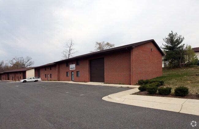

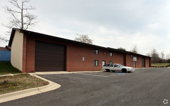
Property Detail
871 Keith Ln
03-168786
LT 14 SEC 2 DUNKIRK BUSINESS CENTER
Warehouse
Calvert
I-1
Maryland
B and X Area of moderate flood hazard, usually the area between the limits of the 100-year and 500-year floods.
14
2025
2.11 AC
2025
Calvert County
860200
Washington, DC
6,240 SF
California-Lexington Park, MD
NEARBY LISTINGS FOR SALE OR LEASE
-
-
View all Owings listings for sale on LoopNet.com
DEMOGRAPHICS near 871 Keith Ln
1 mile
3 mile
5 mile
2025 Total Population
1,495
10,409
34,479
2030 Population
1,491
10,372
34,594
Pop Growth 2025-2030
(0.27%)
(0.36%)
+ 0.33%
Average Age
41
42
41
2025 Total Households
474
3,437
12,139
HH Growth 2025-2030
(0.21%)
(0.44%)
+ 0.28%
Median Household Inc
$175,238
$163,912
$139,596
Avg Household Size
3.10
3.00
2.80
2025 Avg HH Vehicles
3.00
3.00
2.00
Median Home Value
$691,666
$636,309
$527,289
Median Year Built
1997
1990
1987
Nearby Places
Map Layers
Map Styles
 Street
 Aerial
Layers
 Traffic
 Biking
Places
Listings with unknown addresses are not visible on the map
- Restaurants
- Banks
- Shops
- Fitness
- Groceries
PUBLIC TRANSPORTATION
AIRPORT
Ronald Reagan Washington Ntl
Drive
Walk
Distance
Ronald Reagan Washington Ntl
58 min
34.8 mi
Baltimore/Washington International Thurgood Marshall
Drive
Walk
Distance
Baltimore/Washington International Thurgood Marshall
68 min
44.7 mi
Freight Ports
Port of Baltimore
Drive
Walk
Distance
Port of Baltimore
74 min
50.0 mi
Nearby Properties
Address
Land Use
TOTAL SIZE
Lot Size
Zoning
Address
Land Use
TOTAL SIZE
Lot Size
Zoning
18,400 SF
111 AC
RUR
Address
Land Use
TOTAL SIZE
Lot Size
Zoning
23,840 SF
58.70 AC
RUR
Address
Land Use
TOTAL SIZE
Lot Size
Zoning
3,859 SF
28.29 AC
RUR
Address
Land Use
TOTAL SIZE
Lot Size
Zoning
12,294 SF
7.88 AC
R-1
Address
Land Use
TOTAL SIZE
Lot Size
Zoning
37,744 SF
4.06 AC
RUR
Address
Land Use
TOTAL SIZE
Lot Size
Zoning
55,284 SF
6.37 AC
RC
Address
Land Use
TOTAL SIZE
Lot Size
Zoning
44,650 SF
9.36 AC
RUR
Address
Land Use
TOTAL SIZE
Lot Size
Zoning
55,120 SF
15 AC
RUR
Address
Land Use
TOTAL SIZE
Lot Size
Zoning
18,720 SF
9.01 AC
I-1
Address
Land Use
TOTAL SIZE
Lot Size
Zoning
38,380 SF
8.85 AC
I-1
Address
Land Use
TOTAL SIZE
Lot Size
Zoning
22,082 SF
2.96 AC
RC
Address
Land Use
TOTAL SIZE
Lot Size
Zoning
3,050 SF
1.78 AC
RC
Address
Land Use
TOTAL SIZE
Lot Size
Zoning
13,500 SF
2.75 AC
Address
Land Use
TOTAL SIZE
Lot Size
Zoning
10,698 SF
1.36 AC
RC
Address
Land Use
TOTAL SIZE
Lot Size
Zoning
1,560 SF
36.79 AC
I-1
Address
Land Use
TOTAL SIZE
Lot Size
Zoning
13,158 SF
2.24 AC
RC
Address
Land Use
TOTAL SIZE
Lot Size
Zoning
26,784 SF
2.60 AC
I-1
Address
Land Use
TOTAL SIZE
Lot Size
Zoning
5,520 SF
3.99 AC
I-1
Address
Land Use
TOTAL SIZE
Lot Size
Zoning
5,000 SF
2.81 AC
I-1
Address
Land Use
TOTAL SIZE
Lot Size
Zoning
9,600 SF
3.19 AC
I-1
Address
Land Use
TOTAL SIZE
Lot Size
Zoning
600 SF
0.80 AC
I-1
Address
Land Use
TOTAL SIZE
Lot Size
Zoning
12,320 SF
1 AC
RC
Address
Land Use
TOTAL SIZE
Lot Size
Zoning
6,700 SF
1.38 AC
I-1
Address
Land Use
TOTAL SIZE
Lot Size
Zoning
17,490 SF
6.64 AC
I-1
Address
Land Use
TOTAL SIZE
Lot Size
Zoning
14,360 SF
3.02 AC
RC
Address
Land Use
TOTAL SIZE
Lot Size
Zoning
12,076 SF
4.42 AC
RUR
Address
Land Use
TOTAL SIZE
Lot Size
Zoning
9,700 SF
0.85 AC
RC
Address
Land Use
TOTAL SIZE
Lot Size
Zoning
9,023 SF
2.60 AC
RC
Address
Land Use
TOTAL SIZE
Lot Size
Zoning
20,000 SF
4.20 AC
RC
The World's #1 Commercial Real Estate Marketplace
Connect with us
© 2026 CoStar Group
The information above has been obtained from sources believed reliable. While we do not doubt its accuracy we have not verified it and make no guarantee, warranty or representation about it. It is your responsibility to independently confirm its accuracy and completeness. Any projections, opinions, assumptions, or estimates used are for example only and do not represent the current or future performance of the property. The value of this transaction to you depends on tax and other factors which should be evaluated by your tax, financial, and legal advisors. You and your advisors should conduct a careful, independent investigation of the property to determine to your satisfaction the suitability of the property for your needs.