Property Record
8710 I 10 Service Rd, Irvington, AL 36544
NEARBY LISTINGS FOR SALE OR LEASE
Property Detail
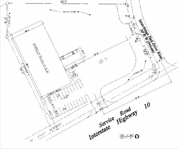
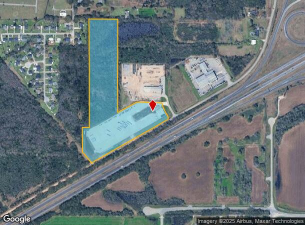
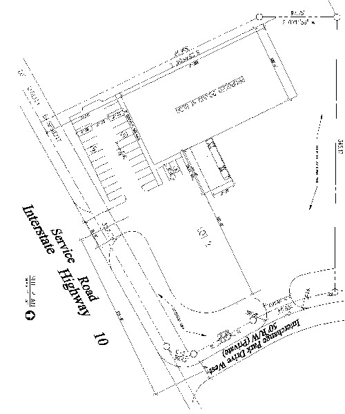
8710 I 10 Service Rd
Mobile, AL
Revised Swift Mobile Alabama Subdivision
37-01-11-0-000-016.056
LOT 1 REVISED SWIFT MOBILE ALABAMA SUBDIVISION 2023056331
Autorepair
Mobile
X
Alabama
01097C0661L
1
2025
24.70 AC
2025
Outlying Mobile County
006501
Mobile
26,460 SF
DEMOGRAPHICS near 8710 I 10 Service Rd
1 Mile
3 Mile
5 Mile
2024 Total Population
557
9,581
34,263
2029 Population
544
9,338
33,434
Pop Growth 2024-2029
(2.33%)
(2.54%)
(2.42%)
Average Age
40
40
39
2024 Total Households
204
3,614
12,869
HH Growth 2024-2029
(2.45%)
(2.60%)
(2.48%)
Median Household Inc
$64,113
$54,307
$52,056
Avg Household Size
2.60
2.50
2.60
2024 Avg HH Vehicles
2.00
2.00
2.00
Median Home Value
$131,068
$144,495
$150,885
Median Year Built
1990
1989
1988
Nearby Places
Map Layers
Map Styles
 Street
 Aerial
- Restaurants
- Banks
- Shops
- Fitness
- Groceries
PUBLIC TRANSPORTATION
AIRPORT
Mobile Regional
DRIVE
WALK
Distance
Mobile Regional
32 min
13.9 mi
Mobile International
DRIVE
WALK
Distance
Mobile International
22 min
14.7 mi
Freight Ports
Port of Mobile
DRIVE
WALK
Distance
Port of Mobile
25 min
18.1 mi
SALE & LEASE HISTORY
LISTING DATE
SALE/LEASE

Sep 25, 2016
For Lease
Nearby Properties
Address
Land Use
TOTAL SIZE
Lot Size
Zoning
Address
Land Use
TOTAL SIZE
Lot Size
Zoning
2,503,800 SF
400.86 AC
Address
Land Use
TOTAL SIZE
Lot Size
Zoning
362,880 SF
32.55 AC
Address
Land Use
TOTAL SIZE
Lot Size
Zoning
155,320 SF
21.48 AC
Address
Land Use
TOTAL SIZE
Lot Size
Zoning
342,598 SF
11.94 AC
Address
Land Use
TOTAL SIZE
Lot Size
Zoning
193,452 SF
17.61 AC
Address
Land Use
TOTAL SIZE
Lot Size
Zoning
70,838 SF
181.63 AC
Address
Land Use
TOTAL SIZE
Lot Size
Zoning
13,550 SF
14.99 AC
Address
Land Use
TOTAL SIZE
Lot Size
Zoning
77,250 SF
10.64 AC
Address
Land Use
TOTAL SIZE
Lot Size
Zoning
41,333 SF
6.35 AC
Address
Land Use
TOTAL SIZE
Lot Size
Zoning
70,597 SF
9.70 AC
Address
Land Use
TOTAL SIZE
Lot Size
Zoning
25,000 SF
10.10 AC
Address
Land Use
TOTAL SIZE
Lot Size
Zoning
15,892 SF
50.23 AC
Address
Land Use
TOTAL SIZE
Lot Size
Zoning
43,440 SF
4.13 AC
Address
Land Use
TOTAL SIZE
Lot Size
Zoning
13,440 SF
10 AC
Address
Land Use
TOTAL SIZE
Lot Size
Zoning
39,708 SF
2.36 AC
Address
Land Use
TOTAL SIZE
Lot Size
Zoning
44,183 SF
11 AC
Address
Land Use
TOTAL SIZE
Lot Size
Zoning
15,125 SF
115.44 AC
Address
Land Use
TOTAL SIZE
Lot Size
Zoning
17,240 SF
10 AC
Address
Land Use
TOTAL SIZE
Lot Size
Zoning
139,790 SF
7.68 AC
Address
Land Use
TOTAL SIZE
Lot Size
Zoning
1,035 SF
150 AC
Address
Land Use
TOTAL SIZE
Lot Size
Zoning
9,080 SF
66.38 AC
Address
Land Use
TOTAL SIZE
Lot Size
Zoning
60,000 SF
4.80 AC
Address
Land Use
TOTAL SIZE
Lot Size
Zoning
7,500 SF
9.91 AC
Address
Land Use
TOTAL SIZE
Lot Size
Zoning
20,244 SF
4.89 AC
Address
Land Use
TOTAL SIZE
Lot Size
Zoning
7,500 SF
1.98 AC
Address
Land Use
TOTAL SIZE
Lot Size
Zoning
1,568 SF
109.14 AC
Address
Land Use
TOTAL SIZE
Lot Size
Zoning
10,500 SF
4.96 AC
The World's #1 Commercial Real Estate Marketplace
Connect with us
© 2025 CoStar Group
The information above has been obtained from sources believed reliable. While we do not doubt its accuracy we have not verified it and make no guarantee, warranty or representation about it. It is your responsibility to independently confirm its accuracy and completeness. Any projections, opinions, assumptions, or estimates used are for example only and do not represent the current or future performance of the property. The value of this transaction to you depends on tax and other factors which should be evaluated by your tax, financial, and legal advisors. You and your advisors should conduct a careful, independent investigation of the property to determine to your satisfaction the suitability of the property for your needs.