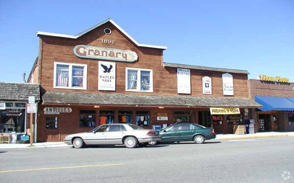
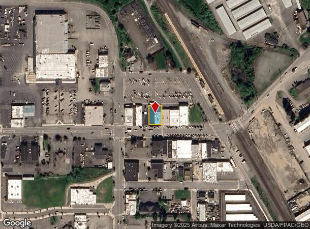
Property Record
8715 271St St Nw, Stanwood, WA 98292
NEARBY LISTINGS FOR SALE OR LEASE
-
-
View all Stanwood listings for sale on LoopNet.com
Property Detail
8715 271St St Nw
Seattle-Tacoma-Bellevue, WA
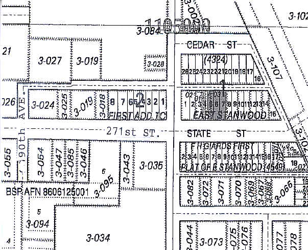
East Stanwood 1St Add
004324-001-005-00
EAST STANWOOD 1ST ADD BLK 001 D-00 - E 8FT LOT 5 - ALL LOTS 6 & 7 - W 2.5FT LOT 8
Storebuilding
Snohomish
AE
Washington
53061C0351F
5-8
2024
0.15 AC
2025
N Snohomish County
053301
Seattle/Puget Sound
6,300 SF
DEMOGRAPHICS near 8715 271St St Nw
1 Mile
3 Mile
5 Mile
2024 Total Population
4,156
11,060
17,465
2029 Population
4,360
11,603
18,284
Pop Growth 2024-2029
+ 4.91%
+ 4.91%
+ 4.69%
Average Age
40
41
42
2024 Total Households
1,554
4,078
6,492
HH Growth 2024-2029
+ 5.21%
+ 5.15%
+ 4.88%
Median Household Inc
$92,652
$91,388
$94,714
Avg Household Size
2.60
2.60
2.60
2024 Avg HH Vehicles
2.00
2.00
2.00
Median Home Value
$493,707
$552,809
$627,733
Median Year Built
1997
1996
1994
Nearby Places
Map Layers
Map Styles
 Street
 Aerial
- Restaurants
- Banks
- Shops
- Fitness
- Groceries
PUBLIC TRANSPORTATION
COMMUTER RAIL
DRIVE
WALK
Distance
0 min
2 min
0.1 mi
AIRPORT
Seattle Paine Field International
DRIVE
WALK
Distance
Seattle Paine Field International
45 min
33.0 mi
Freight Ports
Port of Everett
DRIVE
WALK
Distance
Port of Everett
35 min
25.5 mi
Nearby Properties
Address
Land Use
TOTAL SIZE
Lot Size
Zoning
Address
Land Use
TOTAL SIZE
Lot Size
Zoning
50.30 AC
SR 9.6
Address
Land Use
TOTAL SIZE
Lot Size
Zoning
88,840 SF
28.48 AC
SR 9.6
Address
Land Use
TOTAL SIZE
Lot Size
Zoning
95,736 SF
4.41 AC
MR
Address
Land Use
TOTAL SIZE
Lot Size
Zoning
91,568 SF
2.40 AC
GC
Address
Land Use
TOTAL SIZE
Lot Size
Zoning
119,926 SF
5.33 AC
MR
Address
Land Use
TOTAL SIZE
Lot Size
Zoning
112,967 SF
4.06 AC
GC
Address
Land Use
TOTAL SIZE
Lot Size
Zoning
194,176 SF
4.09 AC
UE
Address
Land Use
TOTAL SIZE
Lot Size
Zoning
60,228 SF
3.69 AC
MR
Address
Land Use
TOTAL SIZE
Lot Size
Zoning
67,800 SF
11.96 AC
SR 9.6
Address
Land Use
TOTAL SIZE
Lot Size
Zoning
61,956 SF
9.54 AC
GC
Address
Land Use
TOTAL SIZE
Lot Size
Zoning
1,038 SF
15.96 AC
SR 9.6
Address
Land Use
TOTAL SIZE
Lot Size
Zoning
44,316 SF
2.38 AC
GC
Address
Land Use
TOTAL SIZE
Lot Size
Zoning
50,411 SF
4.37 AC
MB2
Address
Land Use
TOTAL SIZE
Lot Size
Zoning
42,630 SF
5.51 AC
MR
Address
Land Use
TOTAL SIZE
Lot Size
Zoning
58,782 SF
1.90 AC
GC
Address
Land Use
TOTAL SIZE
Lot Size
Zoning
27,712 SF
0.56 AC
GC
Address
Land Use
TOTAL SIZE
Lot Size
Zoning
1,200 SF
0.69 AC
GC
Address
Land Use
TOTAL SIZE
Lot Size
Zoning
18.56 AC
SR 9.6
Address
Land Use
TOTAL SIZE
Lot Size
Zoning
76,057 SF
17.30 AC
UE
Address
Land Use
TOTAL SIZE
Lot Size
Zoning
28,012 SF
0.55 AC
GC
Address
Land Use
TOTAL SIZE
Lot Size
Zoning
65,338 SF
5.08 AC
LI
Address
Land Use
TOTAL SIZE
Lot Size
Zoning
45,672 SF
1.91 AC
MB2
Address
Land Use
TOTAL SIZE
Lot Size
Zoning
20,409 SF
3.78 AC
SR 9.6
Address
Land Use
TOTAL SIZE
Lot Size
Zoning
43,371 SF
2.22 AC
MR
Address
Land Use
TOTAL SIZE
Lot Size
Zoning
32,845 SF
5.75 AC
SR 7.0
Address
Land Use
TOTAL SIZE
Lot Size
Zoning
28,702 SF
2.41 AC
MB2
Address
Land Use
TOTAL SIZE
Lot Size
Zoning
43,821 SF
11.22 AC
SR 5.0
Address
Land Use
TOTAL SIZE
Lot Size
Zoning
11,540 SF
28.20 AC
R-5
Address
Land Use
TOTAL SIZE
Lot Size
Zoning
51,704 SF
2.17 AC
MR
Address
Land Use
TOTAL SIZE
Lot Size
Zoning
28,625 SF
4.48 AC
SR 9.6
The World's #1 Commercial Real Estate Marketplace
Connect with us
© 2025 CoStar Group
The information above has been obtained from sources believed reliable. While we do not doubt its accuracy we have not verified it and make no guarantee, warranty or representation about it. It is your responsibility to independently confirm its accuracy and completeness. Any projections, opinions, assumptions, or estimates used are for example only and do not represent the current or future performance of the property. The value of this transaction to you depends on tax and other factors which should be evaluated by your tax, financial, and legal advisors. You and your advisors should conduct a careful, independent investigation of the property to determine to your satisfaction the suitability of the property for your needs.