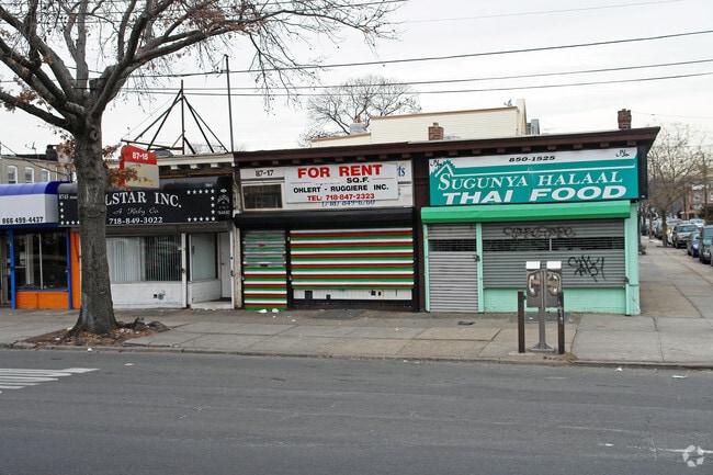
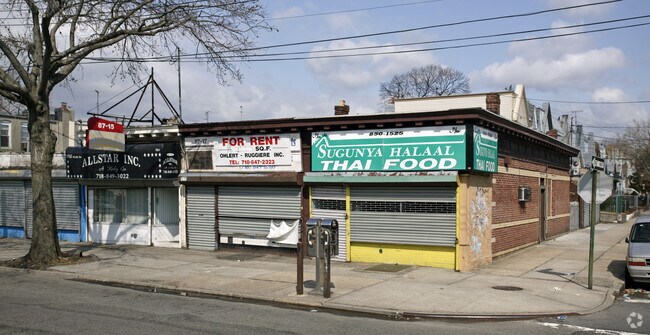
Property Record
8719 Atlantic Ave, Woodhaven, NY 11421

Save to a Folder
{{folder.Name}}
{{folder.ListingIds.length}} Properties
{{folder.ListingIds.length}} Property
Create a New Folder
Property Detail
8719 Atlantic Ave
08981-0030
QUEENS
Storebuilding
New York
R3-1
30
B and X Area of moderate flood hazard, usually the area between the limits of the 100-year and 500-year floods.
0.12 AC
2025
Central Queens
2026
Long Island (New York)
001600
New York-Jersey City-White Plains, NY-NJ
3,152 SF
NEARBY LISTINGS FOR SALE OR LEASE
DEMOGRAPHICS near 8719 Atlantic Ave
1 mile
3 mile
5 mile
2025 Total Population
100,777
704,592
2,052,156
2030 Population
94,870
685,443
2,012,510
Pop Growth 2025-2030
(5.86%)
(2.72%)
(1.93%)
Average Age
40
41
41
2025 Total Households
28,845
241,583
699,461
HH Growth 2025-2030
(6.49%)
(2.86%)
(2.21%)
Median Household Inc
$82,104
$77,984
$72,177
Avg Household Size
3.30
2.80
2.80
2025 Avg HH Vehicles
1.00
1.00
1.00
Median Home Value
$731,615
$698,109
$713,204
Median Year Built
1947
1949
1951
Nearby Places
Map Layers
Map Styles
 Street
 Aerial
Layers
 Traffic
 Biking
Places
Listings with unknown addresses are not visible on the map
- Restaurants
- Banks
- Shops
- Fitness
- Groceries
PUBLIC TRANSPORTATION
TRANSIT/SUBWAY
85 Street-Forest Parkway (J - New York MTA Subway (The Subway))
Drive
Walk
Distance
85 Street-Forest Parkway (J - New York MTA Subway (The Subway))
3 min
12 min
0.6 mi
88 Street (A - New York MTA Subway (The Subway))
Drive
Walk
Distance
88 Street (A - New York MTA Subway (The Subway))
2 min
12 min
0.6 mi
Woodhaven Boulevard (J,Z Line) (J - New York MTA Subway (The Subway), Z - New York MTA Subway (The Subway))
Drive
Walk
Distance
Woodhaven Boulevard (J,Z Line) (J - New York MTA Subway (The Subway), Z - New York MTA Subway (The Subway))
3 min
13 min
0.7 mi
80 Street (A - New York MTA Subway (The Subway))
Drive
Walk
Distance
80 Street (A - New York MTA Subway (The Subway))
3 min
15 min
0.8 mi
75 Street-Elderts Lane (J - New York MTA Subway (The Subway), Z - New York MTA Subway (The Subway))
Drive
Walk
Distance
75 Street-Elderts Lane (J - New York MTA Subway (The Subway), Z - New York MTA Subway (The Subway))
3 min
18 min
1.0 mi
COMMUTER RAIL
Forest Hills Station (Babylon Branch - Long Island Rail Road, Hempstead Branch - Long Island Rail Road, Long Beach Branch - Long Island Rail Road, Port Jefferson Branch - Long Island Rail Road)
Drive
Walk
Distance
Forest Hills Station (Babylon Branch - Long Island Rail Road, Hempstead Branch - Long Island Rail Road, Long Beach Branch - Long Island Rail Road, Port Jefferson Branch - Long Island Rail Road)
9 min
3.2 mi
Kew Gardens Station (Babylon Branch - Long Island Rail Road, Hempstead Branch - Long Island Rail Road, Long Beach Branch - Long Island Rail Road, Port Jefferson Branch - Long Island Rail Road)
Drive
Walk
Distance
Kew Gardens Station (Babylon Branch - Long Island Rail Road, Hempstead Branch - Long Island Rail Road, Long Beach Branch - Long Island Rail Road, Port Jefferson Branch - Long Island Rail Road)
8 min
3.4 mi
AIRPORT
John F Kennedy International
Drive
Walk
Distance
John F Kennedy International
12 min
6.7 mi
LaGuardia
Drive
Walk
Distance
LaGuardia
17 min
9.8 mi
Newark Liberty International
Drive
Walk
Distance
Newark Liberty International
41 min
21.4 mi
Freight Ports
NY - Red Hook Container Terminal
Drive
Walk
Distance
NY - Red Hook Container Terminal
23 min
10.0 mi
Nearby Properties
Address
Land Use
TOTAL SIZE
Lot Size
Zoning
Address
Land Use
TOTAL SIZE
Lot Size
Zoning
266.30 AC
PARK
Address
Land Use
TOTAL SIZE
Lot Size
Zoning
1,845,252 SF
172 AC
C8-1
Address
Land Use
TOTAL SIZE
Lot Size
Zoning
104 AC
PARK
Address
Land Use
TOTAL SIZE
Lot Size
Zoning
54,170 SF
229.57 AC
PARK
Address
Land Use
TOTAL SIZE
Lot Size
Zoning
1,688,760 SF
24.65 AC
R5
Address
Land Use
TOTAL SIZE
Lot Size
Zoning
1,516,458 SF
5.97 AC
R7-1
Address
Land Use
TOTAL SIZE
Lot Size
Zoning
532,011 SF
2.48 AC
R6
Address
Land Use
TOTAL SIZE
Lot Size
Zoning
600 SF
33.07 AC
PARK
Address
Land Use
TOTAL SIZE
Lot Size
Zoning
1,572,198 SF
22.06 AC
M1-2
Address
Land Use
TOTAL SIZE
Lot Size
Zoning
126.85 AC
PARK
Address
Land Use
TOTAL SIZE
Lot Size
Zoning
1,000 SF
210.07 AC
R3-2
Address
Land Use
TOTAL SIZE
Lot Size
Zoning
1,420,000 SF
19.61 AC
R5
Address
Land Use
TOTAL SIZE
Lot Size
Zoning
344,116 SF
0.92 AC
R7-1
Address
Land Use
TOTAL SIZE
Lot Size
Zoning
738,000 SF
1.92 AC
C6-3
Address
Land Use
TOTAL SIZE
Lot Size
Zoning
291,589 SF
1.55 AC
C6-3
Address
Land Use
TOTAL SIZE
Lot Size
Zoning
363,548 SF
1.81 AC
Address
Land Use
TOTAL SIZE
Lot Size
Zoning
2,193 SF
94.72 AC
PARK
Address
Land Use
TOTAL SIZE
Lot Size
Zoning
307,038 SF
7.84 AC
M1-1
Address
Land Use
TOTAL SIZE
Lot Size
Zoning
333,424 SF
1.78 AC
C45D
Address
Land Use
TOTAL SIZE
Lot Size
Zoning
24,400 SF
33.98 AC
C4-2
Address
Land Use
TOTAL SIZE
Lot Size
Zoning
490,600 SF
12.01 AC
M1-1
Address
Land Use
TOTAL SIZE
Lot Size
Zoning
28.64 AC
PARK
Address
Land Use
TOTAL SIZE
Lot Size
Zoning
320,535 SF
1.52 AC
C4-4A
Address
Land Use
TOTAL SIZE
Lot Size
Zoning
1,136,208 SF
30.25 AC
R5
Address
Land Use
TOTAL SIZE
Lot Size
Zoning
997,720 SF
8.23 AC
R5
Address
Land Use
TOTAL SIZE
Lot Size
Zoning
158,402 SF
3.64 AC
C4-2
Address
Land Use
TOTAL SIZE
Lot Size
Zoning
486,306 SF
0.69 AC
C6-4
Address
Land Use
TOTAL SIZE
Lot Size
Zoning
182,614 SF
0.62 AC
C4-5X
Address
Land Use
TOTAL SIZE
Lot Size
Zoning
940,800 SF
11.55 AC
R5
Address
Land Use
TOTAL SIZE
Lot Size
Zoning
230,580 SF
3.41 AC
C8-1
The World's #1 Commercial Real Estate Marketplace
Connect with us
© 2026 CoStar Group
The information above has been obtained from sources believed reliable. While we do not doubt its accuracy we have not verified it and make no guarantee, warranty or representation about it. It is your responsibility to independently confirm its accuracy and completeness. Any projections, opinions, assumptions, or estimates used are for example only and do not represent the current or future performance of the property. The value of this transaction to you depends on tax and other factors which should be evaluated by your tax, financial, and legal advisors. You and your advisors should conduct a careful, independent investigation of the property to determine to your satisfaction the suitability of the property for your needs.