Property Record
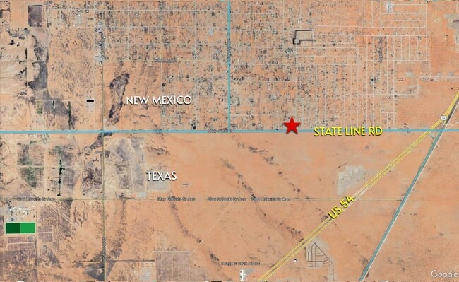
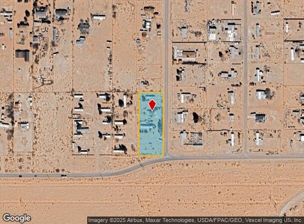
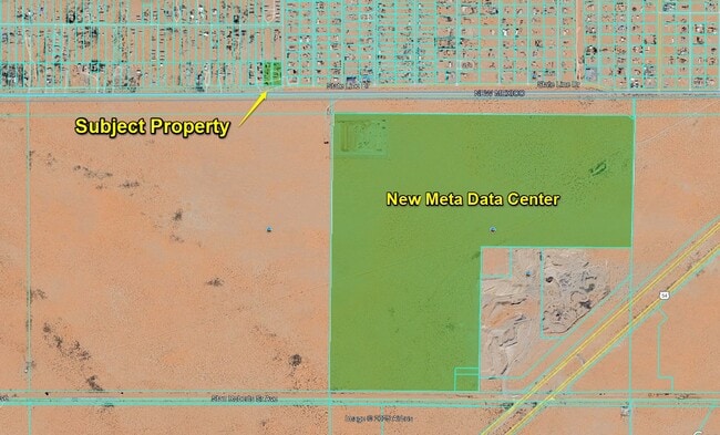
872 State Line Dr, Chaparral, NM 88081
This Property Is For Sale
NEARBY LISTINGS FOR SALE OR LEASE
-
-
View all Chaparral listings for sale on LoopNet.com
Property Detail
872 State Line Dr
Alamogordo, NM
Colquitt
R051317
SUBD: COLQUITT LOT 40 BLOCK: J
Sfr
Otero
X
New Mexico
35035C3025D
40
2024
1.59 AC
2025
Las Cruces/Alamogordo
001810
Other Market Areas
2,055 SF
DEMOGRAPHICS near 872 State Line Dr
1 mile
3 mile
5 mile
2024 Total Population
2,567
14,739
24,119
2029 Population
2,580
15,122
24,869
Pop Growth 2024-2029
+ 0.51%
+ 2.60%
+ 3.11%
Average Age
34
35
34
2024 Total Households
741
4,232
7,107
HH Growth 2024-2029
0.00%
+ 2.41%
+ 2.94%
Median Household Inc
$35,687
$38,949
$43,548
Avg Household Size
3.20
3.10
3.00
2024 Avg HH Vehicles
2.00
2.00
2.00
Median Home Value
$65,116
$94,068
$112,396
Median Year Built
1989
1991
1997
Nearby Places
Map Layers
Map Styles
 Street
 Aerial
Transit
 Traffic
 Biking
Places
Listings with unknown addresses are not visible on the map
- Restaurants
- Banks
- Shops
- Fitness
- Groceries
PUBLIC TRANSPORTATION
AIRPORT
El Paso International
Drive
Walk
Distance
El Paso International
39 min
24.3 mi
Freight Ports
Port of Corpus Christi
Drive
Walk
Distance
Port of Corpus Christi
704 min
711.2 mi
Nearby Properties
Address
Land Use
TOTAL SIZE
Lot Size
Zoning
Address
Land Use
TOTAL SIZE
Lot Size
Zoning
75,275 SF
19 AC
Address
Land Use
TOTAL SIZE
Lot Size
Zoning
25,282 SF
141.95 AC
M1
Address
Land Use
TOTAL SIZE
Lot Size
Zoning
270.51 AC
RF
Address
Land Use
TOTAL SIZE
Lot Size
Zoning
400.65 AC
RF
Address
Land Use
TOTAL SIZE
Lot Size
Zoning
6.56 AC
RF
Address
Land Use
TOTAL SIZE
Lot Size
Zoning
595.57 AC
RF
Address
Land Use
TOTAL SIZE
Lot Size
Zoning
581.26 AC
Q
Address
Land Use
TOTAL SIZE
Lot Size
Zoning
5,488 SF
0.15 AC
C3
Address
Land Use
TOTAL SIZE
Lot Size
Zoning
27,500 SF
0.75 AC
Address
Land Use
TOTAL SIZE
Lot Size
Zoning
4,245 SF
0.13 AC
Address
Land Use
TOTAL SIZE
Lot Size
Zoning
57.43 AC
RF
Address
Land Use
TOTAL SIZE
Lot Size
Zoning
4,063 SF
0.18 AC
Address
Land Use
TOTAL SIZE
Lot Size
Zoning
3,616 SF
0.12 AC
Address
Land Use
TOTAL SIZE
Lot Size
Zoning
3,428 SF
0.11 AC
R5
Address
Land Use
TOTAL SIZE
Lot Size
Zoning
3,288 SF
0.13 AC
Address
Land Use
TOTAL SIZE
Lot Size
Zoning
2,502 SF
0.43 AC
RF
Address
Land Use
TOTAL SIZE
Lot Size
Zoning
3,344 SF
0.12 AC
Address
Land Use
TOTAL SIZE
Lot Size
Zoning
3,291 SF
0.12 AC
Address
Land Use
TOTAL SIZE
Lot Size
Zoning
3,201 SF
0.12 AC
Address
Land Use
TOTAL SIZE
Lot Size
Zoning
3,155 SF
0.15 AC
Address
Land Use
TOTAL SIZE
Lot Size
Zoning
3,185 SF
0.13 AC
Address
Land Use
TOTAL SIZE
Lot Size
Zoning
3,228 SF
0.12 AC
Address
Land Use
TOTAL SIZE
Lot Size
Zoning
3,240 SF
0.12 AC
Address
Land Use
TOTAL SIZE
Lot Size
Zoning
3,255 SF
0.12 AC
Address
Land Use
TOTAL SIZE
Lot Size
Zoning
3,155 SF
0.13 AC
Address
Land Use
TOTAL SIZE
Lot Size
Zoning
3,155 SF
0.13 AC
Address
Land Use
TOTAL SIZE
Lot Size
Zoning
3,549 SF
0.11 AC
R5
Address
Land Use
TOTAL SIZE
Lot Size
Zoning
3,166 SF
0.12 AC
Address
Land Use
TOTAL SIZE
Lot Size
Zoning
3,150 SF
0.12 AC
Address
Land Use
TOTAL SIZE
Lot Size
Zoning
3,128 SF
0.12 AC
The World's #1 Commercial Real Estate Marketplace
Connect with us
© 2026 CoStar Group
The information above has been obtained from sources believed reliable. While we do not doubt its accuracy we have not verified it and make no guarantee, warranty or representation about it. It is your responsibility to independently confirm its accuracy and completeness. Any projections, opinions, assumptions, or estimates used are for example only and do not represent the current or future performance of the property. The value of this transaction to you depends on tax and other factors which should be evaluated by your tax, financial, and legal advisors. You and your advisors should conduct a careful, independent investigation of the property to determine to your satisfaction the suitability of the property for your needs.