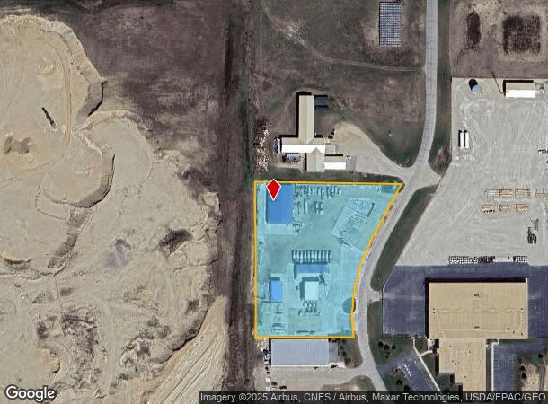
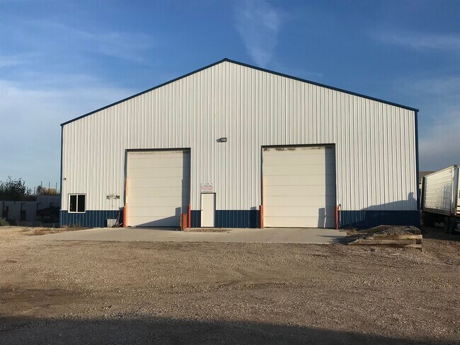
Property Record
8722 47Th St Ne, Spicer, MN 56288

NEARBY LISTINGS FOR SALE OR LEASE
-
-
View all Spicer listings for sale on LoopNet.com
Property Detail
8722 47Th St Ne
Other Market Areas
First Add
Willmar, MN
TOUCHSTONE BUSINESS CENTRE FIRST ADDITION LOT 1, BLK 1
18-875-1000
Kandiyohi
Commercialnec
Minnesota
2025
1
2025
3.77 AC
780400
Minnesota Central Area
DEMOGRAPHICS near 8722 47Th St Ne
1 Mile
3 Mile
5 Mile
2024 Total Population
59
3,641
7,008
2029 Population
58
3,660
7,073
Pop Growth 2024-2029
(1.69%)
+ 0.52%
+ 0.93%
Average Age
43
45
45
2024 Total Households
22
1,512
2,893
HH Growth 2024-2029
0.00%
+ 0.66%
+ 1.04%
Median Household Inc
$104,167
$93,812
$92,179
Avg Household Size
2.50
2.40
2.40
2024 Avg HH Vehicles
3.00
2.00
2.00
Median Home Value
$321,428
$326,007
$330,169
Median Year Built
1981
1983
1983
Nearby Places
Map Layers
Map Styles
 Street
 Aerial
- Restaurants
- Banks
- Shops
- Fitness
- Groceries
SALE & LEASE HISTORY
LISTING DATE
SALE/LEASE

Mar 26, 2020
For Sale
Nearby Properties
Address
Land Use
TOTAL SIZE
Lot Size
Zoning
Address
Land Use
TOTAL SIZE
Lot Size
Zoning
11.41 AC
Address
Land Use
TOTAL SIZE
Lot Size
Zoning
62.30 AC
Address
Land Use
TOTAL SIZE
Lot Size
Zoning
16.65 AC
Address
Land Use
TOTAL SIZE
Lot Size
Zoning
1.56 AC
Address
Land Use
TOTAL SIZE
Lot Size
Zoning
1,056 SF
26.10 AC
Address
Land Use
TOTAL SIZE
Lot Size
Zoning
2.57 AC
Address
Land Use
TOTAL SIZE
Lot Size
Zoning
1.07 AC
Address
Land Use
TOTAL SIZE
Lot Size
Zoning
5.46 AC
Address
Land Use
TOTAL SIZE
Lot Size
Zoning
Address
Land Use
TOTAL SIZE
Lot Size
Zoning
5.95 AC
Address
Land Use
TOTAL SIZE
Lot Size
Zoning
10.51 AC
Address
Land Use
TOTAL SIZE
Lot Size
Zoning
0.88 AC
Address
Land Use
TOTAL SIZE
Lot Size
Zoning
1.03 AC
Address
Land Use
TOTAL SIZE
Lot Size
Zoning
2.87 AC
Address
Land Use
TOTAL SIZE
Lot Size
Zoning
4.24 AC
Address
Land Use
TOTAL SIZE
Lot Size
Zoning
1.36 AC
Address
Land Use
TOTAL SIZE
Lot Size
Zoning
1.02 AC
Address
Land Use
TOTAL SIZE
Lot Size
Zoning
0.68 AC
Address
Land Use
TOTAL SIZE
Lot Size
Zoning
Address
Land Use
TOTAL SIZE
Lot Size
Zoning
3.73 AC
Address
Land Use
TOTAL SIZE
Lot Size
Zoning
1.36 AC
Address
Land Use
TOTAL SIZE
Lot Size
Zoning
4.92 AC
Address
Land Use
TOTAL SIZE
Lot Size
Zoning
Address
Land Use
TOTAL SIZE
Lot Size
Zoning
114 AC
Address
Land Use
TOTAL SIZE
Lot Size
Zoning
137.66 AC
Address
Land Use
TOTAL SIZE
Lot Size
Zoning
0.50 AC
Address
Land Use
TOTAL SIZE
Lot Size
Zoning
2.65 AC
Address
Land Use
TOTAL SIZE
Lot Size
Zoning
0.51 AC
Address
Land Use
TOTAL SIZE
Lot Size
Zoning
120 AC
The World's #1 Commercial Real Estate Marketplace
Connect with us
© 2025 CoStar Group
The information above has been obtained from sources believed reliable. While we do not doubt its accuracy we have not verified it and make no guarantee, warranty or representation about it. It is your responsibility to independently confirm its accuracy and completeness. Any projections, opinions, assumptions, or estimates used are for example only and do not represent the current or future performance of the property. The value of this transaction to you depends on tax and other factors which should be evaluated by your tax, financial, and legal advisors. You and your advisors should conduct a careful, independent investigation of the property to determine to your satisfaction the suitability of the property for your needs.