Property Record
8727 Sw 24Th St, Miami, FL 33165
NEARBY LISTINGS FOR SALE OR LEASE
Property Detail
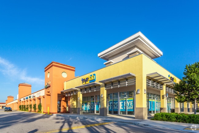
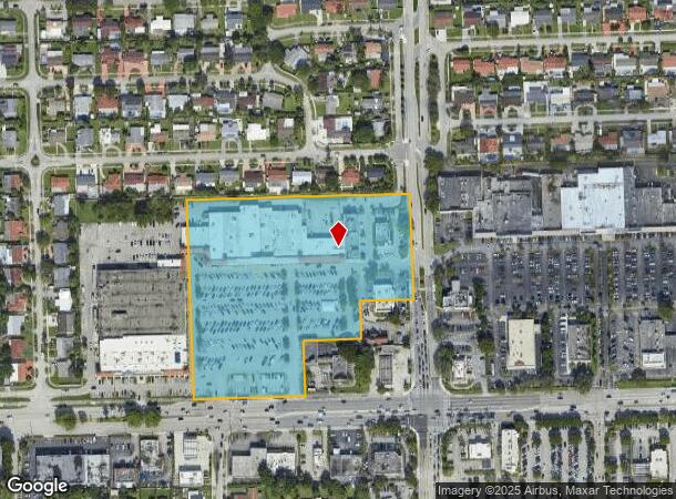
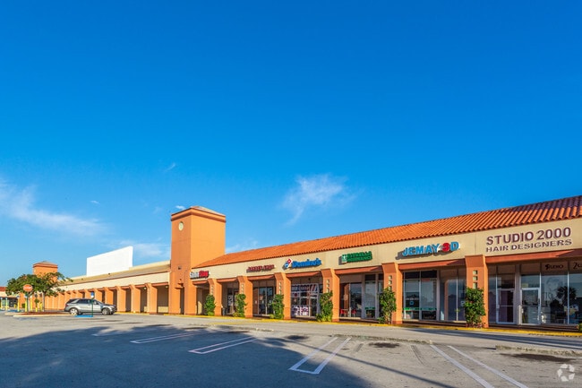
8727 Sw 24Th St
30-4009-009-0010
Coral Park Ests
Regionalshoppingcenterormallwithanchorstore
CORAL PARK ESTS SEC 1 REPLAT PB 73-51 8.291 AC M/L TR A LESS W350FT & LESS E150FT OF S150FT & LESS N150FT OF S300 FT OF E170FT & LESS BEG 690.80 FT E OF SW COR TR A N180.50FT E182.06FT S30.50FT E20.40FT S150FT W202.46FT TO POB LOT SIZE 361161 FT
AH
Miami/Dade
12086C0452L
Florida
2024
8.29 AC
2025
West Miami
008909
South Florida
75,387 SF
Miami-Miami Beach-Kendall, FL
DEMOGRAPHICS near 8727 Sw 24Th St
1 Mile
3 Mile
5 Mile
2024 Total Population
20,203
189,150
437,297
2029 Population
19,450
183,951
426,567
Pop Growth 2024-2029
(3.73%)
(2.75%)
(2.45%)
Average Age
45
44
43
2024 Total Households
6,515
64,210
156,570
HH Growth 2024-2029
(4.33%)
(3.10%)
(2.72%)
Median Household Inc
$69,313
$60,283
$65,135
Avg Household Size
2.90
2.80
2.70
2024 Avg HH Vehicles
2.00
2.00
2.00
Median Home Value
$414,243
$377,913
$406,058
Median Year Built
1965
1974
1976
Nearby Places
Map Layers
Map Styles
 Street
 Aerial
- Restaurants
- Banks
- Shops
- Fitness
- Groceries
PUBLIC TRANSPORTATION
COMMUTER RAIL
South Miami (Metrorail Green Line - Miami-Dade Transit (Metrorail/Metromover))
DRIVE
WALK
Distance
South Miami (Metrorail Green Line - Miami-Dade Transit (Metrorail/Metromover))
11 min
6.5 mi
University (Metrorail Green Line - Miami-Dade Transit (Metrorail/Metromover))
DRIVE
WALK
Distance
University (Metrorail Green Line - Miami-Dade Transit (Metrorail/Metromover))
13 min
7.4 mi
AIRPORT
Miami International
DRIVE
WALK
Distance
Miami International
15 min
7.1 mi
Fort Lauderdale/Hollywood International
DRIVE
WALK
Distance
Fort Lauderdale/Hollywood International
47 min
33.2 mi
Freight Ports
Port of Miami
DRIVE
WALK
Distance
Port of Miami
24 min
14.2 mi
SALE & LEASE HISTORY
LISTING DATE
SALE/LEASE

Sep 24, 2016
For Lease
Nov 03, 2016
For Lease
May 10, 2021
For Lease
Jul 24, 2019
For Sale
Jul 20, 2021
For Sale
Aug 06, 2021
For Sale
Apr 23, 2018
For Lease
Nearby Properties
Address
Land Use
TOTAL SIZE
Lot Size
Zoning
Address
Land Use
TOTAL SIZE
Lot Size
Zoning
4,384,261 SF
343.66 AC
6400
Address
Land Use
TOTAL SIZE
Lot Size
Zoning
1,647,481 SF
23.04 AC
5000
Address
Land Use
TOTAL SIZE
Lot Size
Zoning
784,416 SF
1.72 AC
6480
Address
Land Use
TOTAL SIZE
Lot Size
Zoning
1,680,493 SF
23.71 AC
4100
Address
Land Use
TOTAL SIZE
Lot Size
Zoning
465,663 SF
11.29 AC
4100
Address
Land Use
TOTAL SIZE
Lot Size
Zoning
671,088 SF
19.84 AC
6400
Address
Land Use
TOTAL SIZE
Lot Size
Zoning
868,154 SF
1.71 AC
6480
Address
Land Use
TOTAL SIZE
Lot Size
Zoning
762,624 SF
1.70 AC
6480
Address
Land Use
TOTAL SIZE
Lot Size
Zoning
423,104 SF
2.58 AC
6200
Address
Land Use
TOTAL SIZE
Lot Size
Zoning
500,332 SF
3.46 AC
6000
Address
Land Use
TOTAL SIZE
Lot Size
Zoning
535,679 SF
2.73 AC
6000
Address
Land Use
TOTAL SIZE
Lot Size
Zoning
429,568 SF
7.44 AC
6400
Address
Land Use
TOTAL SIZE
Lot Size
Zoning
438,387 SF
16.20 AC
3900
Address
Land Use
TOTAL SIZE
Lot Size
Zoning
428,212 SF
17.56 AC
3900
Address
Land Use
TOTAL SIZE
Lot Size
Zoning
366,237 SF
9.24 AC
4100
Address
Land Use
TOTAL SIZE
Lot Size
Zoning
369,180 SF
2.07 AC
6200
Address
Land Use
TOTAL SIZE
Lot Size
Zoning
476,094 SF
1.09 AC
6480
Address
Land Use
TOTAL SIZE
Lot Size
Zoning
353,267 SF
30.40 AC
6400
Address
Land Use
TOTAL SIZE
Lot Size
Zoning
667,273 SF
38.34 AC
6400
Address
Land Use
TOTAL SIZE
Lot Size
Zoning
367,347 SF
2.07 AC
6200
Address
Land Use
TOTAL SIZE
Lot Size
Zoning
229,154 SF
9.02 AC
3900
Address
Land Use
TOTAL SIZE
Lot Size
Zoning
540,199 SF
24.93 AC
6400
Address
Land Use
TOTAL SIZE
Lot Size
Zoning
251,834 SF
31.85 AC
6200
Address
Land Use
TOTAL SIZE
Lot Size
Zoning
321,726 SF
1.35 AC
6200
Address
Land Use
TOTAL SIZE
Lot Size
Zoning
611,978 SF
11.41 AC
3900
Address
Land Use
TOTAL SIZE
Lot Size
Zoning
349,295 SF
25.16 AC
6061
Address
Land Use
TOTAL SIZE
Lot Size
Zoning
309,432 SF
272.32 AC
8900
Address
Land Use
TOTAL SIZE
Lot Size
Zoning
93,557 SF
24.05 AC
6400
Address
Land Use
TOTAL SIZE
Lot Size
Zoning
305,718 SF
3.26 AC
6400
Address
Land Use
TOTAL SIZE
Lot Size
Zoning
450,683 SF
22.55 AC
7600
The World's #1 Commercial Real Estate Marketplace
Connect with us
© 2025 CoStar Group
The information above has been obtained from sources believed reliable. While we do not doubt its accuracy we have not verified it and make no guarantee, warranty or representation about it. It is your responsibility to independently confirm its accuracy and completeness. Any projections, opinions, assumptions, or estimates used are for example only and do not represent the current or future performance of the property. The value of this transaction to you depends on tax and other factors which should be evaluated by your tax, financial, and legal advisors. You and your advisors should conduct a careful, independent investigation of the property to determine to your satisfaction the suitability of the property for your needs.