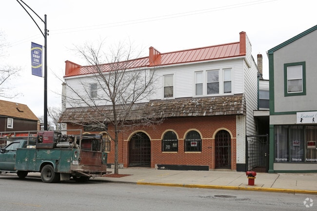
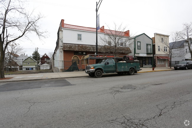
Property Record
8725 S Commercial Ave, Chicago, IL 60617
NEARBY LISTINGS FOR SALE OR LEASE
Property Detail
8725 S Commercial Ave
26-06-203-010-0000
Calumet & Chicago Canal & Dock
Miscresidentialimprovement
Cook
X
Illinois
17031C0656K
37
2023
0.08 AC
2025
South Chicago
460800
Chicago
8,994 SF
Chicago-Naperville-Elgin, IL-IN-WI
DEMOGRAPHICS near 8725 S Commercial Ave
1 Mile
3 Mile
5 Mile
2024 Total Population
22,135
148,734
322,259
2029 Population
21,185
143,940
312,427
Pop Growth 2024-2029
(4.29%)
(3.22%)
(3.05%)
Average Age
40
41
40
2024 Total Households
8,533
63,656
136,698
HH Growth 2024-2029
(4.56%)
(3.42%)
(3.31%)
Median Household Inc
$34,854
$40,070
$41,355
Avg Household Size
2.50
2.30
2.20
2024 Avg HH Vehicles
1.00
1.00
1.00
Median Home Value
$158,078
$170,510
$174,383
Median Year Built
1945
1947
1948
Nearby Places
Map Layers
Map Styles
 Street
 Aerial
- Restaurants
- Banks
- Shops
- Fitness
- Groceries
PUBLIC TRANSPORTATION
TRANSIT/SUBWAY
87th Street Station (Metra Electric Line - Northeast Illinois Regional Commuter Railroad (Metra))
DRIVE
WALK
Distance
87th Street Station (Metra Electric Line - Northeast Illinois Regional Commuter Railroad (Metra))
1 min
5 min
0.2 mi
83rd Street Station (Metra Electric Line - Northeast Illinois Regional Commuter Railroad (Metra))
DRIVE
WALK
Distance
83rd Street Station (Metra Electric Line - Northeast Illinois Regional Commuter Railroad (Metra))
3 min
12 min
0.6 mi
South Chicago (93rd Street) Station (Metra Electric Line - Northeast Illinois Regional Commuter Railroad (Metra))
DRIVE
WALK
Distance
South Chicago (93rd Street) Station (Metra Electric Line - Northeast Illinois Regional Commuter Railroad (Metra))
4 min
19 min
0.9 mi
COMMUTER RAIL
Longwood Station (Rock Island District Line - Northeast Illinois Regional Commuter Railroad (Metra))
DRIVE
WALK
Distance
Longwood Station (Rock Island District Line - Northeast Illinois Regional Commuter Railroad (Metra))
19 min
7.2 mi
Gresham Station (Rock Island District Line - Northeast Illinois Regional Commuter Railroad (Metra))
DRIVE
WALK
Distance
Gresham Station (Rock Island District Line - Northeast Illinois Regional Commuter Railroad (Metra))
18 min
9.6 mi
AIRPORT
Chicago Midway International
DRIVE
WALK
Distance
Chicago Midway International
30 min
19.2 mi
Chicago O'Hare International
DRIVE
WALK
Distance
Chicago O'Hare International
41 min
30.7 mi
SALE & LEASE HISTORY
LISTING DATE
SALE/LEASE

Sep 25, 2016
For Lease
Nearby Properties
Address
Land Use
TOTAL SIZE
Lot Size
Zoning
Address
Land Use
TOTAL SIZE
Lot Size
Zoning
0.49 AC
SLI
Address
Land Use
TOTAL SIZE
Lot Size
Zoning
112,300 SF
2.34 AC
Address
Land Use
TOTAL SIZE
Lot Size
Zoning
109,145 SF
0.46 AC
RM-5
Address
Land Use
TOTAL SIZE
Lot Size
Zoning
115,000 SF
1.97 AC
C1-2
Address
Land Use
TOTAL SIZE
Lot Size
Zoning
Address
Land Use
TOTAL SIZE
Lot Size
Zoning
62,216 SF
0.65 AC
RM-5
Address
Land Use
TOTAL SIZE
Lot Size
Zoning
115,000 SF
1.12 AC
C1-2
Address
Land Use
TOTAL SIZE
Lot Size
Zoning
23,799 SF
0.91 AC
PD 571
Address
Land Use
TOTAL SIZE
Lot Size
Zoning
0.84 AC
RM-5
Address
Land Use
TOTAL SIZE
Lot Size
Zoning
12,334 SF
53.37 AC
PD 1160
Address
Land Use
TOTAL SIZE
Lot Size
Zoning
15,052 SF
1.03 AC
PQ
Address
Land Use
TOTAL SIZE
Lot Size
Zoning
Address
Land Use
TOTAL SIZE
Lot Size
Zoning
145,291 SF
7.85 AC
B3-2
Address
Land Use
TOTAL SIZE
Lot Size
Zoning
289,850 SF
1.46 AC
RM-6
Address
Land Use
TOTAL SIZE
Lot Size
Zoning
25,977 SF
0.46 AC
RM-5
Address
Land Use
TOTAL SIZE
Lot Size
Zoning
0.30 AC
RT-4
Address
Land Use
TOTAL SIZE
Lot Size
Zoning
30,240 SF
0.17 AC
B1-2
Address
Land Use
TOTAL SIZE
Lot Size
Zoning
76,867 SF
3.44 AC
M1-1
Address
Land Use
TOTAL SIZE
Lot Size
Zoning
207,100 SF
9.84 AC
M2-2
Address
Land Use
TOTAL SIZE
Lot Size
Zoning
87,400 SF
34.39 AC
PD 1560
Address
Land Use
TOTAL SIZE
Lot Size
Zoning
9.55 AC
M2-2
Address
Land Use
TOTAL SIZE
Lot Size
Zoning
Address
Land Use
TOTAL SIZE
Lot Size
Zoning
256,864 SF
1.15 AC
RM-6
Address
Land Use
TOTAL SIZE
Lot Size
Zoning
72,219 SF
4.30 AC
M1-2
Address
Land Use
TOTAL SIZE
Lot Size
Zoning
84,400 SF
15.18 AC
M2-2,M1-1
Address
Land Use
TOTAL SIZE
Lot Size
Zoning
115,918 SF
4.08 AC
M1-2,C1-1
Address
Land Use
TOTAL SIZE
Lot Size
Zoning
12.42 AC
PD 485
Address
Land Use
TOTAL SIZE
Lot Size
Zoning
22,818 SF
0.25 AC
RM-5
Address
Land Use
TOTAL SIZE
Lot Size
Zoning
71,700 SF
6.24 AC
PD 485
Address
Land Use
TOTAL SIZE
Lot Size
Zoning
81,200 SF
5.44 AC
C1-3
The World's #1 Commercial Real Estate Marketplace
Connect with us
© 2026 CoStar Group
The information above has been obtained from sources believed reliable. While we do not doubt its accuracy we have not verified it and make no guarantee, warranty or representation about it. It is your responsibility to independently confirm its accuracy and completeness. Any projections, opinions, assumptions, or estimates used are for example only and do not represent the current or future performance of the property. The value of this transaction to you depends on tax and other factors which should be evaluated by your tax, financial, and legal advisors. You and your advisors should conduct a careful, independent investigation of the property to determine to your satisfaction the suitability of the property for your needs.