Property Record
873 Worcester St, Wellesley, MA 02482
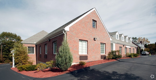


Property Detail
873 Worcester St
WELL-000182-000042
Norfolk
Officebuilding
Massachusetts
B and X Area of moderate flood hazard, usually the area between the limits of the 100-year and 500-year floods.
0.60 AC
2025
Wellesley/Needham
2025
Boston
404301
Boston-Cambridge-Newton, MA-NH
NEARBY LISTINGS FOR SALE OR LEASE
DEMOGRAPHICS near 873 Worcester St
1 mile
3 mile
5 mile
2025 Total Population
10,019
58,876
157,928
2030 Population
10,325
60,850
163,628
Pop Growth 2025-2030
+ 3.05%
+ 3.35%
+ 3.61%
Average Age
41
41
41
2025 Total Households
3,334
19,699
56,665
HH Growth 2025-2030
+ 3.15%
+ 3.58%
+ 3.76%
Median Household Inc
$233,333
$210,202
$175,436
Avg Household Size
3.00
2.70
2.60
2025 Avg HH Vehicles
2.00
2.00
2.00
Median Home Value
$1,078,164
$1,042,558
$1,024,882
Median Year Built
1957
1957
1960
Nearby Places
Map Layers
Map Styles
 Street
 Aerial
Layers
 Traffic
 Biking
Places
Listings with unknown addresses are not visible on the map
- Restaurants
- Banks
- Shops
- Fitness
- Groceries
PUBLIC TRANSPORTATION
COMMUTER RAIL
Wellesley Square (Framingham/Worcester Line - Massachusetts Bay Transportation Authority Commuter Rail (Purple Line))
Drive
Walk
Distance
Wellesley Square (Framingham/Worcester Line - Massachusetts Bay Transportation Authority Commuter Rail (Purple Line))
3 min
1.5 mi
Wellesley Hills (Framingham/Worcester Line - Massachusetts Bay Transportation Authority Commuter Rail (Purple Line))
Drive
Walk
Distance
Wellesley Hills (Framingham/Worcester Line - Massachusetts Bay Transportation Authority Commuter Rail (Purple Line))
5 min
2.6 mi
AIRPORT
General Edward Lawrence Logan International
Drive
Walk
Distance
General Edward Lawrence Logan International
30 min
18.7 mi
Worcester Regional
Drive
Walk
Distance
Worcester Regional
52 min
30.6 mi
Freight Ports
Port of Boston
Drive
Walk
Distance
Port of Boston
29 min
17.0 mi
SALE & LEASE HISTORY
LISTING DATE
SALE/LEASE

Sep 24, 2016
For Lease
Nearby Properties
Address
Land Use
TOTAL SIZE
Lot Size
Zoning
Address
Land Use
TOTAL SIZE
Lot Size
Zoning
10.87 AC
SRD 10
Address
Land Use
TOTAL SIZE
Lot Size
Zoning
15,974 SF
2.45 AC
ED
Address
Land Use
TOTAL SIZE
Lot Size
Zoning
6.33 AC
SR10
Address
Land Use
TOTAL SIZE
Lot Size
Zoning
189,858 SF
61.45 AC
A
Address
Land Use
TOTAL SIZE
Lot Size
Zoning
179,963 SF
41.28 AC
A
Address
Land Use
TOTAL SIZE
Lot Size
Zoning
165,382 SF
12.46 AC
HPU
Address
Land Use
TOTAL SIZE
Lot Size
Zoning
15.08 AC
SR10
Address
Land Use
TOTAL SIZE
Lot Size
Zoning
1,683 SF
46.10 AC
SR15
Address
Land Use
TOTAL SIZE
Lot Size
Zoning
122,748 SF
16.90 AC
HPU
Address
Land Use
TOTAL SIZE
Lot Size
Zoning
49.88 AC
T
Address
Land Use
TOTAL SIZE
Lot Size
Zoning
79.30 AC
RSA
Address
Land Use
TOTAL SIZE
Lot Size
Zoning
3.80 AC
Address
Land Use
TOTAL SIZE
Lot Size
Zoning
25.70 AC
SR10
Address
Land Use
TOTAL SIZE
Lot Size
Zoning
80.85 AC
SR40
Address
Land Use
TOTAL SIZE
Lot Size
Zoning
13,244 SF
12.72 AC
SR10
Address
Land Use
TOTAL SIZE
Lot Size
Zoning
75,625 SF
23.23 AC
B
Address
Land Use
TOTAL SIZE
Lot Size
Zoning
29,022 SF
4.89 AC
RG
Address
Land Use
TOTAL SIZE
Lot Size
Zoning
7.15 AC
Address
Land Use
TOTAL SIZE
Lot Size
Zoning
73,257 SF
10.23 AC
RSA
Address
Land Use
TOTAL SIZE
Lot Size
Zoning
1,592 SF
10.65 AC
ED
Address
Land Use
TOTAL SIZE
Lot Size
Zoning
7.85 AC
SR10
Address
Land Use
TOTAL SIZE
Lot Size
Zoning
1.43 AC
Address
Land Use
TOTAL SIZE
Lot Size
Zoning
105 AC
SRD 30
Address
Land Use
TOTAL SIZE
Lot Size
Zoning
45.04 AC
ED
Address
Land Use
TOTAL SIZE
Lot Size
Zoning
455 SF
18.97 AC
SR10
Address
Land Use
TOTAL SIZE
Lot Size
Zoning
182.10 AC
O
Address
Land Use
TOTAL SIZE
Lot Size
Zoning
28.45 AC
Address
Land Use
TOTAL SIZE
Lot Size
Zoning
14.06 AC
ED
Address
Land Use
TOTAL SIZE
Lot Size
Zoning
39 AC
ED
Address
Land Use
TOTAL SIZE
Lot Size
Zoning
119,139 SF
6.86 AC
RSA
The World's #1 Commercial Real Estate Marketplace
Connect with us
© 2026 CoStar Group
The information above has been obtained from sources believed reliable. While we do not doubt its accuracy we have not verified it and make no guarantee, warranty or representation about it. It is your responsibility to independently confirm its accuracy and completeness. Any projections, opinions, assumptions, or estimates used are for example only and do not represent the current or future performance of the property. The value of this transaction to you depends on tax and other factors which should be evaluated by your tax, financial, and legal advisors. You and your advisors should conduct a careful, independent investigation of the property to determine to your satisfaction the suitability of the property for your needs.