Property Record
8730 S Highway 181, Kenedy, TX 78119

Save to a Folder
{{folder.Name}}
{{folder.ListingIds.length}} Properties
{{folder.ListingIds.length}} Property
Create a New Folder
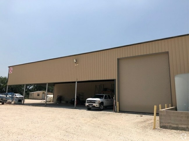
Property Detail
8730 S Highway 181
107-6340
AB 6 C MARTINEZ TR 5-4 UNIT B (202500000056) (202000004338)
Commercialnec
KARNES
B and X Area of moderate flood hazard, usually the area between the limits of the 100-year and 500-year floods.
Texas
2025
27.73 AC
2025
Texas South Area
970301
Other Market Areas
NEARBY LISTINGS FOR SALE OR LEASE
-
-
View all Kenedy listings for sale on LoopNet.com
DEMOGRAPHICS near 8730 S Highway 181
1 mile
3 mile
5 mile
2025 Total Population
76
4,850
6,369
2030 Population
78
4,986
6,590
Pop Growth 2025-2030
+ 2.63%
+ 2.80%
+ 3.47%
Average Age
44
42
42
2025 Total Households
10
1,420
1,891
HH Growth 2025-2030
+ 10.00%
+ 3.59%
+ 4.44%
Median Household Inc
$39,999
$51,554
$45,089
Avg Household Size
2.40
2.50
2.50
2025 Avg HH Vehicles
2.00
2.00
2.00
Median Home Value
$125,000
$129,616
$129,350
Median Year Built
1989
1982
1983
Nearby Places
Map Layers
Map Styles
 Street
 Aerial
Layers
 Traffic
 Biking
Places
Listings with unknown addresses are not visible on the map
- Restaurants
- Banks
- Shops
- Fitness
- Groceries
SALE & LEASE HISTORY
LISTING DATE
SALE/LEASE

Nov 21, 2019
For Sale
Nearby Properties
Address
Land Use
TOTAL SIZE
Lot Size
Zoning
Address
Land Use
TOTAL SIZE
Lot Size
Zoning
14,736 SF
3.28 AC
Address
Land Use
TOTAL SIZE
Lot Size
Zoning
41,484 SF
4.34 AC
Address
Land Use
TOTAL SIZE
Lot Size
Zoning
50,000 SF
7.17 AC
Address
Land Use
TOTAL SIZE
Lot Size
Zoning
22,550 SF
0.96 AC
Address
Land Use
TOTAL SIZE
Lot Size
Zoning
27,008 SF
2.79 AC
Address
Land Use
TOTAL SIZE
Lot Size
Zoning
11,585 SF
Address
Land Use
TOTAL SIZE
Lot Size
Zoning
45,323 SF
7.80 AC
Address
Land Use
TOTAL SIZE
Lot Size
Zoning
29,752 SF
10 AC
Address
Land Use
TOTAL SIZE
Lot Size
Zoning
24,096 SF
2.70 AC
Address
Land Use
TOTAL SIZE
Lot Size
Zoning
18,563 SF
4.89 AC
Address
Land Use
TOTAL SIZE
Lot Size
Zoning
9,600 SF
13.93 AC
Address
Land Use
TOTAL SIZE
Lot Size
Zoning
24,360 SF
0.27 AC
Address
Land Use
TOTAL SIZE
Lot Size
Zoning
11,194 SF
3.74 AC
Address
Land Use
TOTAL SIZE
Lot Size
Zoning
11,648 SF
15.70 AC
Address
Land Use
TOTAL SIZE
Lot Size
Zoning
2,003 SF
1.42 AC
Address
Land Use
TOTAL SIZE
Lot Size
Zoning
10,765 SF
3.95 AC
Address
Land Use
TOTAL SIZE
Lot Size
Zoning
16,640 SF
1.56 AC
Address
Land Use
TOTAL SIZE
Lot Size
Zoning
20,806 SF
5.95 AC
Address
Land Use
TOTAL SIZE
Lot Size
Zoning
2,300 SF
25.23 AC
Address
Land Use
TOTAL SIZE
Lot Size
Zoning
1,616 SF
1.57 AC
Address
Land Use
TOTAL SIZE
Lot Size
Zoning
5,334 SF
1.77 AC
Address
Land Use
TOTAL SIZE
Lot Size
Zoning
23,712 SF
3.15 AC
Address
Land Use
TOTAL SIZE
Lot Size
Zoning
1,600 SF
200.41 AC
Address
Land Use
TOTAL SIZE
Lot Size
Zoning
8,610 SF
4.12 AC
Address
Land Use
TOTAL SIZE
Lot Size
Zoning
26,979 SF
2.25 AC
Address
Land Use
TOTAL SIZE
Lot Size
Zoning
14,780 SF
5 AC
Address
Land Use
TOTAL SIZE
Lot Size
Zoning
4,329 SF
5 AC
Address
Land Use
TOTAL SIZE
Lot Size
Zoning
3,479 SF
1.56 AC
Address
Land Use
TOTAL SIZE
Lot Size
Zoning
Address
Land Use
TOTAL SIZE
Lot Size
Zoning
11,325 SF
8.94 AC
The World's #1 Commercial Real Estate Marketplace
Connect with us
© 2026 CoStar Group
The information above has been obtained from sources believed reliable. While we do not doubt its accuracy we have not verified it and make no guarantee, warranty or representation about it. It is your responsibility to independently confirm its accuracy and completeness. Any projections, opinions, assumptions, or estimates used are for example only and do not represent the current or future performance of the property. The value of this transaction to you depends on tax and other factors which should be evaluated by your tax, financial, and legal advisors. You and your advisors should conduct a careful, independent investigation of the property to determine to your satisfaction the suitability of the property for your needs.