Property Record
8731 E M 89 Ave, Richland, MI 49083
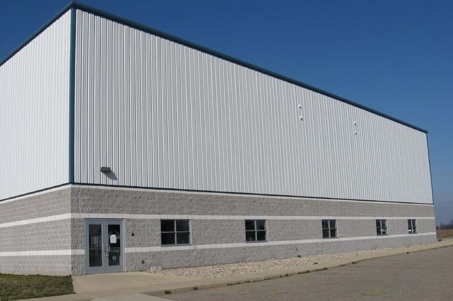

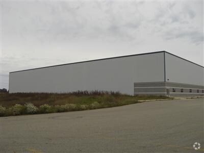
Property Detail
8731 E M 89 Ave
03-10-455-030
SEC 10-1-10 COMM AT S1/4 POST TH N 89-47'27" E ALG S SEC LI 760 FT TO POB TH CON'T N 89-47'27" E 565.43 FT TO E L W1/2 SE1/4
Commercialnec
KALAMAZOO
D-1
Michigan
B and X Area of moderate flood hazard, usually the area between the limits of the 100-year and 500-year floods.
11.93 AC
2025
NE Kalamazoo County
2025
West Michigan
002701
Kalamazoo-Portage, MI
32,400 SF
NEARBY LISTINGS FOR SALE OR LEASE
DEMOGRAPHICS near 8731 E M 89 Ave
1 mile
3 mile
5 mile
2025 Total Population
1,153
6,549
15,554
2030 Population
1,157
6,596
15,797
Pop Growth 2025-2030
+ 0.35%
+ 0.72%
+ 1.56%
Average Age
40
42
43
2025 Total Households
434
2,519
6,021
HH Growth 2025-2030
+ 0.23%
+ 0.67%
+ 1.63%
Median Household Inc
$89,492
$104,046
$106,214
Avg Household Size
2.70
2.60
2.60
2025 Avg HH Vehicles
2.00
2.00
2.00
Median Home Value
$298,928
$349,528
$358,194
Median Year Built
1987
1981
1982
Nearby Places
Map Layers
Map Styles
 Street
 Aerial
Layers
 Traffic
 Biking
Places
Listings with unknown addresses are not visible on the map
- Restaurants
- Banks
- Shops
- Fitness
- Groceries
PUBLIC TRANSPORTATION
AIRPORT
Kalamazoo/Battle Creek International
Drive
Walk
Distance
Kalamazoo/Battle Creek International
28 min
13.7 mi
Gerald R Ford International
Drive
Walk
Distance
Gerald R Ford International
67 min
49.3 mi
Nearby Properties
Address
Land Use
TOTAL SIZE
Lot Size
Zoning
Address
Land Use
TOTAL SIZE
Lot Size
Zoning
163.30 AC
A
Address
Land Use
TOTAL SIZE
Lot Size
Zoning
135,080 SF
30 AC
D
Address
Land Use
TOTAL SIZE
Lot Size
Zoning
6,087 SF
2.44 AC
R-1
Address
Land Use
TOTAL SIZE
Lot Size
Zoning
37,027 SF
133.10 AC
R/OS
Address
Land Use
TOTAL SIZE
Lot Size
Zoning
1,757 SF
509.49 AC
A-1
Address
Land Use
TOTAL SIZE
Lot Size
Zoning
17,662 SF
3.72 AC
D
Address
Land Use
TOTAL SIZE
Lot Size
Zoning
183.43 AC
A-1
Address
Land Use
TOTAL SIZE
Lot Size
Zoning
0.94 AC
R-1
Address
Land Use
TOTAL SIZE
Lot Size
Zoning
38.66 AC
A-1
Address
Land Use
TOTAL SIZE
Lot Size
Zoning
1.15 AC
R-1
Address
Land Use
TOTAL SIZE
Lot Size
Zoning
26,398 SF
5.75 AC
Address
Land Use
TOTAL SIZE
Lot Size
Zoning
26,576 SF
13.80 AC
B-1
Address
Land Use
TOTAL SIZE
Lot Size
Zoning
1,435 SF
326.34 AC
A-1
Address
Land Use
TOTAL SIZE
Lot Size
Zoning
18,588 SF
7.67 AC
D
Address
Land Use
TOTAL SIZE
Lot Size
Zoning
3.61 AC
P1
Address
Land Use
TOTAL SIZE
Lot Size
Zoning
277.46 AC
AB
Address
Land Use
TOTAL SIZE
Lot Size
Zoning
1.95 AC
D
Address
Land Use
TOTAL SIZE
Lot Size
Zoning
42,006 SF
20 AC
D
Address
Land Use
TOTAL SIZE
Lot Size
Zoning
54,576 SF
6.06 AC
D-1
Address
Land Use
TOTAL SIZE
Lot Size
Zoning
61,620 SF
7.39 AC
D
Address
Land Use
TOTAL SIZE
Lot Size
Zoning
29,280 SF
6.40 AC
B-1
Address
Land Use
TOTAL SIZE
Lot Size
Zoning
21,560 SF
3.37 AC
D
Address
Land Use
TOTAL SIZE
Lot Size
Zoning
7,200 SF
1.48 AC
D-1
Address
Land Use
TOTAL SIZE
Lot Size
Zoning
1,350 SF
188.63 AC
A-1
Address
Land Use
TOTAL SIZE
Lot Size
Zoning
Address
Land Use
TOTAL SIZE
Lot Size
Zoning
31,380 SF
5 AC
D
Address
Land Use
TOTAL SIZE
Lot Size
Zoning
Address
Land Use
TOTAL SIZE
Lot Size
Zoning
2,436 SF
80 AC
A-1
Address
Land Use
TOTAL SIZE
Lot Size
Zoning
19,296 SF
3.10 AC
B-1
Address
Land Use
TOTAL SIZE
Lot Size
Zoning
19,296 SF
3.10 AC
B-1
The World's #1 Commercial Real Estate Marketplace
Connect with us
© 2026 CoStar Group
The information above has been obtained from sources believed reliable. While we do not doubt its accuracy we have not verified it and make no guarantee, warranty or representation about it. It is your responsibility to independently confirm its accuracy and completeness. Any projections, opinions, assumptions, or estimates used are for example only and do not represent the current or future performance of the property. The value of this transaction to you depends on tax and other factors which should be evaluated by your tax, financial, and legal advisors. You and your advisors should conduct a careful, independent investigation of the property to determine to your satisfaction the suitability of the property for your needs.