Property Record
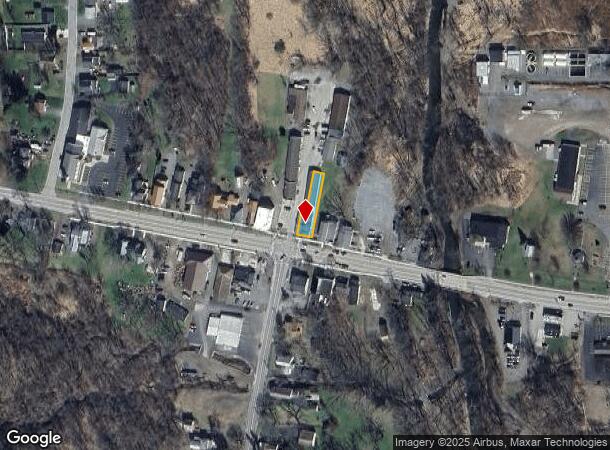
8732 Main St, Honeoye, NY 14471

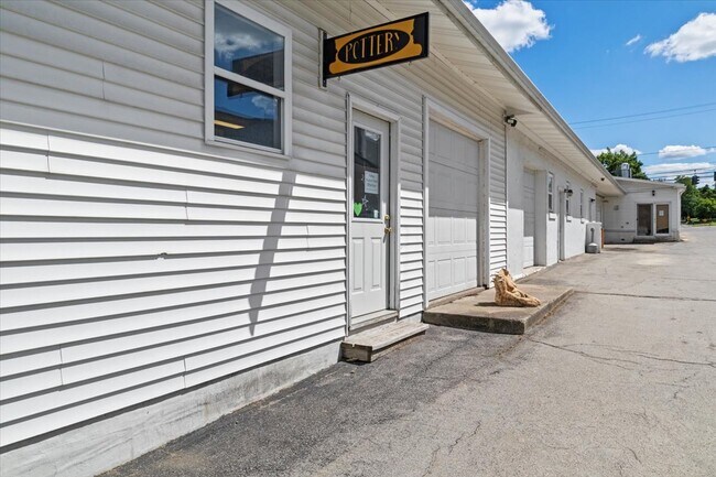
This Property Is For Sale
NEARBY LISTINGS FOR SALE OR LEASE
Property Detail
8732 Main St
Rochester, NY
4830 BRIARCLIFF SQ
324200-135-020-0001-013-120
Ontario
Commercialbuilding
New York
2025
13.120
2024
0.19 AC
052003
Outlying Ontario County
7,486 SF
Rochester
DEMOGRAPHICS near 8732 Main St
1 Mile
3 Mile
5 Mile
2024 Total Population
626
3,081
6,131
2029 Population
627
3,104
6,146
Pop Growth 2024-2029
+ 0.16%
+ 0.75%
+ 0.24%
Average Age
46
48
47
2024 Total Households
296
1,422
2,743
HH Growth 2024-2029
+ 0.34%
+ 0.77%
+ 0.33%
Median Household Inc
$65,263
$70,808
$73,574
Avg Household Size
2.10
2.10
2.20
2024 Avg HH Vehicles
2.00
2.00
2.00
Median Home Value
$172,767
$194,243
$192,477
Median Year Built
1957
1965
1971
Nearby Places
Map Layers
Map Styles
 Street
 Aerial
- Restaurants
- Banks
- Shops
- Fitness
- Groceries
PUBLIC TRANSPORTATION
AIRPORT
Frederick Douglass/Greater Rochester International
DRIVE
WALK
Distance
Frederick Douglass/Greater Rochester International
50 min
35.3 mi
Freight Ports
Albany, NY Port
DRIVE
WALK
Distance
Albany, NY Port
269 min
223.6 mi
Nearby Properties
Address
Land Use
TOTAL SIZE
Lot Size
Zoning
Address
Land Use
TOTAL SIZE
Lot Size
Zoning
177,021 SF
43.90 AC
01 - NOT Z
Address
Land Use
TOTAL SIZE
Lot Size
Zoning
2,314 SF
1.20 AC
06 - INDUS
Address
Land Use
TOTAL SIZE
Lot Size
Zoning
24.50 AC
05 - COMME
Address
Land Use
TOTAL SIZE
Lot Size
Zoning
Address
Land Use
TOTAL SIZE
Lot Size
Zoning
124,800 SF
8.50 AC
06 - INDUS
Address
Land Use
TOTAL SIZE
Lot Size
Zoning
45.70 AC
01 - NOT Z
Address
Land Use
TOTAL SIZE
Lot Size
Zoning
Address
Land Use
TOTAL SIZE
Lot Size
Zoning
75,300 SF
15.10 AC
06 - INDUS
Address
Land Use
TOTAL SIZE
Lot Size
Zoning
01 - NOT Z
Address
Land Use
TOTAL SIZE
Lot Size
Zoning
24,544 SF
5.80 AC
01 - NOT Z
Address
Land Use
TOTAL SIZE
Lot Size
Zoning
Address
Land Use
TOTAL SIZE
Lot Size
Zoning
3,360 SF
5.30 AC
05 - COMME
Address
Land Use
TOTAL SIZE
Lot Size
Zoning
4,704 SF
2.90 AC
05 - COMME
Address
Land Use
TOTAL SIZE
Lot Size
Zoning
4,992 SF
57.30 AC
02 - SINGL
Address
Land Use
TOTAL SIZE
Lot Size
Zoning
6,600 SF
4.90 AC
06 - INDUS
Address
Land Use
TOTAL SIZE
Lot Size
Zoning
Address
Land Use
TOTAL SIZE
Lot Size
Zoning
Address
Land Use
TOTAL SIZE
Lot Size
Zoning
0.01 AC
01 - NOT Z
Address
Land Use
TOTAL SIZE
Lot Size
Zoning
10,640 SF
3.10 AC
03 - MULTI
Address
Land Use
TOTAL SIZE
Lot Size
Zoning
0.91 AC
02 - SINGL
Address
Land Use
TOTAL SIZE
Lot Size
Zoning
112.70 AC
02 - SINGL
Address
Land Use
TOTAL SIZE
Lot Size
Zoning
0.17 AC
05 - COMME
Address
Land Use
TOTAL SIZE
Lot Size
Zoning
21,900 SF
2.80 AC
05 - COMME
Address
Land Use
TOTAL SIZE
Lot Size
Zoning
480 SF
11 AC
05 - COMME
Address
Land Use
TOTAL SIZE
Lot Size
Zoning
2,860 SF
2 AC
01 - NOT Z
Address
Land Use
TOTAL SIZE
Lot Size
Zoning
10,426 SF
8.70 AC
05 - COMME
Address
Land Use
TOTAL SIZE
Lot Size
Zoning
6,944 SF
1.80 AC
06 - INDUS
Address
Land Use
TOTAL SIZE
Lot Size
Zoning
6,360 SF
0.59 AC
05 - COMME
Address
Land Use
TOTAL SIZE
Lot Size
Zoning
7,880 SF
2.20 AC
02 - SINGL
Address
Land Use
TOTAL SIZE
Lot Size
Zoning
600.10 AC
01 - NOT Z
The World's #1 Commercial Real Estate Marketplace
Connect with us
© 2026 CoStar Group
The information above has been obtained from sources believed reliable. While we do not doubt its accuracy we have not verified it and make no guarantee, warranty or representation about it. It is your responsibility to independently confirm its accuracy and completeness. Any projections, opinions, assumptions, or estimates used are for example only and do not represent the current or future performance of the property. The value of this transaction to you depends on tax and other factors which should be evaluated by your tax, financial, and legal advisors. You and your advisors should conduct a careful, independent investigation of the property to determine to your satisfaction the suitability of the property for your needs.