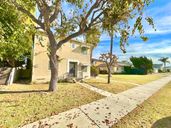
Property Record
8738 Ramsgate Ave, Los Angeles, CA 90045


NEARBY LISTINGS FOR SALE OR LEASE
Property Detail
8738 Ramsgate Ave
Los Angeles-Long Beach-Glendale, CA
15283
4125-015-014
Los Angeles
Triplex
California
X
0.16 AC
06037C1760F
Westchester
3,128 SF
Los Angeles
DEMOGRAPHICS near 8738 Ramsgate Ave
1 Mile
3 Mile
5 Mile
2024 Total Population
14,174
216,147
650,508
2029 Population
13,988
210,001
633,468
Pop Growth 2024-2029
(1.31%)
(2.84%)
(2.62%)
Average Age
43
40
40
2024 Total Households
5,752
81,020
251,992
HH Growth 2024-2029
(1.41%)
(3.07%)
(2.90%)
Median Household Inc
$113,315
$93,863
$93,838
Avg Household Size
2.40
2.60
2.50
2024 Avg HH Vehicles
2.00
2.00
2.00
Median Home Value
$1,089,279
$1,015,870
$989,992
Median Year Built
1955
1964
1963
Nearby Places
Map Layers
Map Styles
 Street
 Aerial
- Restaurants
- Banks
- Shops
- Fitness
- Groceries
PUBLIC TRANSPORTATION
AIRPORT
Los Angeles International
DRIVE
WALK
Distance
Los Angeles International
7 min
2.6 mi
Long Beach (Daugherty Field)
DRIVE
WALK
Distance
Long Beach (Daugherty Field)
28 min
19.8 mi
Bob Hope
DRIVE
WALK
Distance
Bob Hope
39 min
26.9 mi
Freight Ports
Port of Long Beach
DRIVE
WALK
Distance
Port of Long Beach
32 min
21.8 mi
SALE & LEASE HISTORY
LISTING DATE
SALE/LEASE

Jul 30, 2025
For Sale
Nearby Properties
Address
Land Use
TOTAL SIZE
Lot Size
Zoning
Address
Land Use
TOTAL SIZE
Lot Size
Zoning
514,260 SF
13.76 AC
LAMPV
Address
Land Use
TOTAL SIZE
Lot Size
Zoning
1,007,400 SF
6.45 AC
LAM(PV)
Address
Land Use
TOTAL SIZE
Lot Size
Zoning
1,807,845 SF
7.28 AC
ESC3
Address
Land Use
TOTAL SIZE
Lot Size
Zoning
512,019 SF
10.70 AC
LAC2(PV)
Address
Land Use
TOTAL SIZE
Lot Size
Zoning
362,414 SF
20.88 AC
LAM1
Address
Land Use
TOTAL SIZE
Lot Size
Zoning
Address
Land Use
TOTAL SIZE
Lot Size
Zoning
Address
Land Use
TOTAL SIZE
Lot Size
Zoning
Address
Land Use
TOTAL SIZE
Lot Size
Zoning
Address
Land Use
TOTAL SIZE
Lot Size
Zoning
131,967 SF
94.08 AC
LAR4
Address
Land Use
TOTAL SIZE
Lot Size
Zoning
658,463 SF
6.81 AC
LAC2(PV)
Address
Land Use
TOTAL SIZE
Lot Size
Zoning
1,315,931 SF
3.36 AC
ESC3
Address
Land Use
TOTAL SIZE
Lot Size
Zoning
402,060 SF
3.58 AC
LAC2
Address
Land Use
TOTAL SIZE
Lot Size
Zoning
670,596 SF
11.60 AC
LAR4
Address
Land Use
TOTAL SIZE
Lot Size
Zoning
482,248 SF
5.09 AC
LAR4(PV)
Address
Land Use
TOTAL SIZE
Lot Size
Zoning
321,055 SF
5.98 AC
LAM(PV)
Address
Land Use
TOTAL SIZE
Lot Size
Zoning
9.38 AC
LAR4(PV)
Address
Land Use
TOTAL SIZE
Lot Size
Zoning
565,264 SF
5.95 AC
Address
Land Use
TOTAL SIZE
Lot Size
Zoning
530,988 SF
8 AC
LAM2
Address
Land Use
TOTAL SIZE
Lot Size
Zoning
724,715 SF
5.76 AC
INCR*
Address
Land Use
TOTAL SIZE
Lot Size
Zoning
9.38 AC
LAR4(PV)
Address
Land Use
TOTAL SIZE
Lot Size
Zoning
522,511 SF
4.91 AC
LARAS4
Address
Land Use
TOTAL SIZE
Lot Size
Zoning
297,937 SF
1.59 AC
CCC3*
Address
Land Use
TOTAL SIZE
Lot Size
Zoning
283,733 SF
2.82 AC
CCC3
Address
Land Use
TOTAL SIZE
Lot Size
Zoning
329,810 SF
2.21 AC
LAC2
Address
Land Use
TOTAL SIZE
Lot Size
Zoning
622,357 SF
3.42 AC
LAC2
Address
Land Use
TOTAL SIZE
Lot Size
Zoning
384,621 SF
2.50 AC
LAR4(PV)
Address
Land Use
TOTAL SIZE
Lot Size
Zoning
459,058 SF
8.84 AC
ESC3*
Address
Land Use
TOTAL SIZE
Lot Size
Zoning
632,476 SF
10.56 AC
LAC2
Address
Land Use
TOTAL SIZE
Lot Size
Zoning
145,427 SF
2.06 AC
LAC2(PV)
The World's #1 Commercial Real Estate Marketplace
Connect with us
© 2026 CoStar Group
The information above has been obtained from sources believed reliable. While we do not doubt its accuracy we have not verified it and make no guarantee, warranty or representation about it. It is your responsibility to independently confirm its accuracy and completeness. Any projections, opinions, assumptions, or estimates used are for example only and do not represent the current or future performance of the property. The value of this transaction to you depends on tax and other factors which should be evaluated by your tax, financial, and legal advisors. You and your advisors should conduct a careful, independent investigation of the property to determine to your satisfaction the suitability of the property for your needs.