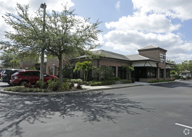
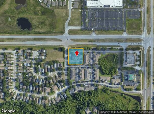
Property Record
8740 Mitchell Blvd, New Port Richey, FL 34655

NEARBY LISTINGS FOR SALE OR LEASE
Property Detail
8740 Mitchell Blvd
Tampa-St. Petersburg-Clearwater, FL
Thousand Oaks Multi-Family
35-26-16-0000-00500-0122
PORTION OF NE 1/4 OF SEC 35 DESC AS COM AT NE COR OF THOUSAND OAKS MULTI-FAMILY PB 40 PG 9 FOR POB TH S89DEG 2916E 200.00 FT TH S00DEG 3044W 215.00 FT TH N89DEG 2916W 200.00 FT TH N00DEG 3044E 215.00 FT TO POB SUBJECT TO UTILITY EASEMENT PER OR 8704
Officebuilding
Pasco
X
Florida
12101C0366F
122
2024
0.99 AC
2025
Pasco County
031507
Tampa/St Petersburg
8,458 SF
DEMOGRAPHICS near 8740 Mitchell Blvd
1 Mile
3 Mile
5 Mile
2024 Total Population
6,169
48,835
137,072
2029 Population
7,327
58,315
162,659
Pop Growth 2024-2029
+ 18.77%
+ 19.41%
+ 18.67%
Average Age
40
43
44
2024 Total Households
2,194
19,244
57,489
HH Growth 2024-2029
+ 18.82%
+ 19.35%
+ 18.74%
Median Household Inc
$93,474
$71,633
$56,224
Avg Household Size
2.80
2.50
2.30
2024 Avg HH Vehicles
2.00
2.00
2.00
Median Home Value
$348,057
$296,894
$238,171
Median Year Built
2001
1995
1986
Nearby Places
Map Layers
Map Styles
 Street
 Aerial
- Restaurants
- Banks
- Shops
- Fitness
- Groceries
PUBLIC TRANSPORTATION
AIRPORT
St Pete-Clearwater International
DRIVE
WALK
Distance
St Pete-Clearwater International
45 min
25.7 mi
Tampa International
DRIVE
WALK
Distance
Tampa International
43 min
29.5 mi
Freight Ports
Port of Tampa Bay
DRIVE
WALK
Distance
Port of Tampa Bay
55 min
35.0 mi
Nearby Properties
Address
Land Use
TOTAL SIZE
Lot Size
Zoning
Address
Land Use
TOTAL SIZE
Lot Size
Zoning
417,700 SF
28.91 AC
MPUD
Address
Land Use
TOTAL SIZE
Lot Size
Zoning
339,446 SF
16.29 AC
MPUD
Address
Land Use
TOTAL SIZE
Lot Size
Zoning
384,700 SF
18.90 AC
MF3
Address
Land Use
TOTAL SIZE
Lot Size
Zoning
403,054 SF
117.69 AC
MPUD
Address
Land Use
TOTAL SIZE
Lot Size
Zoning
203,571 SF
13.82 AC
C2
Address
Land Use
TOTAL SIZE
Lot Size
Zoning
314,948 SF
55.04 AC
MPUD
Address
Land Use
TOTAL SIZE
Lot Size
Zoning
143,332 SF
17.40 AC
C2
Address
Land Use
TOTAL SIZE
Lot Size
Zoning
152,300 SF
2.82 AC
MF3
Address
Land Use
TOTAL SIZE
Lot Size
Zoning
1,017 AC
AR
Address
Land Use
TOTAL SIZE
Lot Size
Zoning
113,034 SF
15.21 AC
MPUD
Address
Land Use
TOTAL SIZE
Lot Size
Zoning
114,831 SF
7.98 AC
MF2
Address
Land Use
TOTAL SIZE
Lot Size
Zoning
59,874 SF
7.73 AC
MPUD
Address
Land Use
TOTAL SIZE
Lot Size
Zoning
116,607 SF
3.88 AC
MPUD
Address
Land Use
TOTAL SIZE
Lot Size
Zoning
83,958 SF
18.56 AC
MPUD
Address
Land Use
TOTAL SIZE
Lot Size
Zoning
135,600 SF
13.34 AC
MF1
Address
Land Use
TOTAL SIZE
Lot Size
Zoning
55,440 SF
41.22 AC
RPD05
Address
Land Use
TOTAL SIZE
Lot Size
Zoning
70,248 SF
27.90 AC
R4
Address
Land Use
TOTAL SIZE
Lot Size
Zoning
89,242 SF
14.28 AC
MPUD
Address
Land Use
TOTAL SIZE
Lot Size
Zoning
217,376 SF
22.12 AC
C2
Address
Land Use
TOTAL SIZE
Lot Size
Zoning
245.25 AC
PRM
Address
Land Use
TOTAL SIZE
Lot Size
Zoning
112,703 SF
8.43 AC
C2
Address
Land Use
TOTAL SIZE
Lot Size
Zoning
85,547 SF
16.13 AC
MPUD
Address
Land Use
TOTAL SIZE
Lot Size
Zoning
106,039 SF
3.03 AC
MPUD
Address
Land Use
TOTAL SIZE
Lot Size
Zoning
85,600 SF
13.40 AC
C2
Address
Land Use
TOTAL SIZE
Lot Size
Zoning
89,308 SF
0.58 AC
C2
Address
Land Use
TOTAL SIZE
Lot Size
Zoning
75,844 SF
2.75 AC
C2
Address
Land Use
TOTAL SIZE
Lot Size
Zoning
83,628 SF
4.09 AC
MPUD
Address
Land Use
TOTAL SIZE
Lot Size
Zoning
26,743 SF
7.32 AC
RPD05
Address
Land Use
TOTAL SIZE
Lot Size
Zoning
93,304 SF
18.82 AC
MF1
Address
Land Use
TOTAL SIZE
Lot Size
Zoning
133,304 SF
13.48 AC
C2
The World's #1 Commercial Real Estate Marketplace
Connect with us
© 2025 CoStar Group
The information above has been obtained from sources believed reliable. While we do not doubt its accuracy we have not verified it and make no guarantee, warranty or representation about it. It is your responsibility to independently confirm its accuracy and completeness. Any projections, opinions, assumptions, or estimates used are for example only and do not represent the current or future performance of the property. The value of this transaction to you depends on tax and other factors which should be evaluated by your tax, financial, and legal advisors. You and your advisors should conduct a careful, independent investigation of the property to determine to your satisfaction the suitability of the property for your needs.