Property Record
8732 S Sandy Pky, Sandy, UT 84070
NEARBY LISTINGS FOR SALE OR LEASE
Property Detail
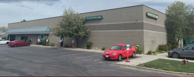
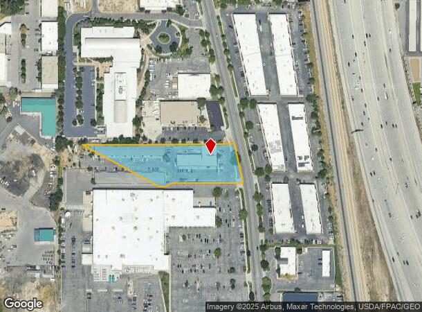
8732 S Sandy Pky
27-01-101-043-0000
Radius Curve
Multipleuses
BEG S 636.63 FT & E 1518.03 FT FR NW COR OF SEC 1, T 3S, R 1W, SLM; S 12^3735 E 105.86 FT; SELY ALG A 1376.408 FT RADIUS CURVE TO R 64.45 FT; N 89^4907 W 308.18 FT; S 60^ W30 FT; N 89^4907 W 29.83 FT; N 61^4632 W 374.61 FT; N 89^4316 E 657.14 FT TO B
X
Salt Lake
49035C0434G
Utah
2024
2 AC
2025
Sandy
112406
Salt Lake City
35,240 SF
Salt Lake City, UT
DEMOGRAPHICS near 8732 S Sandy Pky
1 Mile
3 Mile
5 Mile
2024 Total Population
13,921
127,482
337,047
2029 Population
14,172
129,141
340,326
Pop Growth 2024-2029
+ 1.80%
+ 1.30%
+ 0.97%
Average Age
34
37
38
2024 Total Households
5,080
46,942
116,960
HH Growth 2024-2029
+ 1.81%
+ 1.31%
+ 0.93%
Median Household Inc
$68,984
$75,649
$88,245
Avg Household Size
2.70
2.70
2.80
2024 Avg HH Vehicles
2.00
2.00
2.00
Median Home Value
$358,428
$406,930
$461,728
Median Year Built
1987
1990
1987
Nearby Places
Map Layers
Map Styles
 Street
 Aerial
- Restaurants
- Banks
- Shops
- Fitness
- Groceries
PUBLIC TRANSPORTATION
COMMUTER RAIL
South Jordan Station (FrontRunner - Utah Transit Authority (UTA))
DRIVE
WALK
Distance
South Jordan Station (FrontRunner - Utah Transit Authority (UTA))
5 min
2.3 mi
Draper Station (FrontRunner - Utah Transit Authority (UTA))
DRIVE
WALK
Distance
Draper Station (FrontRunner - Utah Transit Authority (UTA))
11 min
6.4 mi
AIRPORT
Salt Lake City International
DRIVE
WALK
Distance
Salt Lake City International
23 min
18.0 mi
Provo Municipal
DRIVE
WALK
Distance
Provo Municipal
44 min
33.7 mi
Freight Ports
Port of Stockton
DRIVE
WALK
Distance
Port of Stockton
723 min
708.4 mi
SALE & LEASE HISTORY
LISTING DATE
SALE/LEASE

May 01, 2020
For Lease
Nearby Properties
Address
Land Use
TOTAL SIZE
Lot Size
Zoning
Address
Land Use
TOTAL SIZE
Lot Size
Zoning
235,963 SF
35.56 AC
SF1-DO
Address
Land Use
TOTAL SIZE
Lot Size
Zoning
512,301 SF
25.39 AC
SD(H)
Address
Land Use
TOTAL SIZE
Lot Size
Zoning
258,000 SF
13.25 AC
1D
Address
Land Use
TOTAL SIZE
Lot Size
Zoning
552,994 SF
13.64 AC
SD-X
Address
Land Use
TOTAL SIZE
Lot Size
Zoning
198,801 SF
8.36 AC
R-3-20
Address
Land Use
TOTAL SIZE
Lot Size
Zoning
427,884 SF
18.22 AC
JB-4
Address
Land Use
TOTAL SIZE
Lot Size
Zoning
153,245 SF
27.10 AC
PUD137
Address
Land Use
TOTAL SIZE
Lot Size
Zoning
566,327 SF
7.02 AC
CBD-O
Address
Land Use
TOTAL SIZE
Lot Size
Zoning
458,458 SF
6.05 AC
MU
Address
Land Use
TOTAL SIZE
Lot Size
Zoning
224,049 SF
5.29 AC
MU
Address
Land Use
TOTAL SIZE
Lot Size
Zoning
497,522 SF
16.43 AC
MH
Address
Land Use
TOTAL SIZE
Lot Size
Zoning
372,355 SF
13.80 AC
C-F
Address
Land Use
TOTAL SIZE
Lot Size
Zoning
500,249 SF
3.16 AC
MU
Address
Land Use
TOTAL SIZE
Lot Size
Zoning
106,318 SF
4.46 AC
CBD-O
Address
Land Use
TOTAL SIZE
Lot Size
Zoning
500,249 SF
3.16 AC
MU
Address
Land Use
TOTAL SIZE
Lot Size
Zoning
679,800 SF
18.14 AC
BJ-1-3
Address
Land Use
TOTAL SIZE
Lot Size
Zoning
280,668 SF
12 AC
CBD
Address
Land Use
TOTAL SIZE
Lot Size
Zoning
81,865 SF
19.46 AC
Z-C-FF
Address
Land Use
TOTAL SIZE
Lot Size
Zoning
448,232 SF
9.08 AC
PC
Address
Land Use
TOTAL SIZE
Lot Size
Zoning
143,600 SF
7.56 AC
2000
Address
Land Use
TOTAL SIZE
Lot Size
Zoning
327,940 SF
3.95 AC
SD
Address
Land Use
TOTAL SIZE
Lot Size
Zoning
103,114 SF
14.82 AC
RM 25
Address
Land Use
TOTAL SIZE
Lot Size
Zoning
74,120 SF
12.61 AC
BJ
Address
Land Use
TOTAL SIZE
Lot Size
Zoning
321,397 SF
11.16 AC
BJ
Address
Land Use
TOTAL SIZE
Lot Size
Zoning
327,940 SF
3.37 AC
SD
Address
Land Use
TOTAL SIZE
Lot Size
Zoning
379,911 SF
5.78 AC
mu
Address
Land Use
TOTAL SIZE
Lot Size
Zoning
45,924 SF
18.15 AC
R-3-20
Address
Land Use
TOTAL SIZE
Lot Size
Zoning
192,626 SF
5.72 AC
CF
Address
Land Use
TOTAL SIZE
Lot Size
Zoning
289,838 SF
24.11 AC
BJ-3
Address
Land Use
TOTAL SIZE
Lot Size
Zoning
117,521 SF
57.92 AC
PF
The World's #1 Commercial Real Estate Marketplace
Connect with us
© 2025 CoStar Group
The information above has been obtained from sources believed reliable. While we do not doubt its accuracy we have not verified it and make no guarantee, warranty or representation about it. It is your responsibility to independently confirm its accuracy and completeness. Any projections, opinions, assumptions, or estimates used are for example only and do not represent the current or future performance of the property. The value of this transaction to you depends on tax and other factors which should be evaluated by your tax, financial, and legal advisors. You and your advisors should conduct a careful, independent investigation of the property to determine to your satisfaction the suitability of the property for your needs.