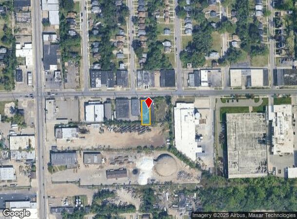
Property Record
8747 Lyndon St, Detroit, MI 48238
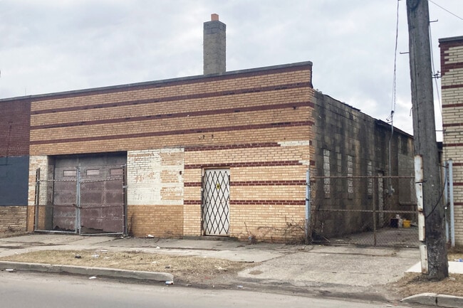
This Property Is For Sale
Current Lease Availabilities
NEARBY LISTINGS FOR SALE OR LEASE
Property Detail
8747 Lyndon St
16-005903-044
Assessors Detroit Plat No
Industrialgeneral
S LYNDON 265 ASSESSORS DETROIT PLAT NO 19 L74 P27 PLATS, W C R 16/468 6,752 SQ FT
X
Wayne
26163C0100E
Michigan
2024
0.16 AC
2025
Detroit West
536600
Detroit
2,800 SF
Detroit-Warren-Dearborn, MI
DEMOGRAPHICS near 8747 Lyndon St
1 Mile
3 Mile
5 Mile
2024 Total Population
15,813
171,104
444,214
2029 Population
15,939
170,982
441,338
Pop Growth 2024-2029
+ 0.80%
(0.07%)
(0.65%)
Average Age
38
39
38
2024 Total Households
6,102
68,762
171,534
HH Growth 2024-2029
+ 0.80%
+ 0.05%
(0.48%)
Median Household Inc
$33,164
$34,813
$37,926
Avg Household Size
2.50
2.40
2.50
2024 Avg HH Vehicles
1.00
1.00
1.00
Median Home Value
$58,045
$82,132
$91,515
Median Year Built
1947
1947
1948
Nearby Places
Map Layers
Map Styles
 Street
 Aerial
- Restaurants
- Banks
- Shops
- Fitness
- Groceries
PUBLIC TRANSPORTATION
COMMUTER RAIL
Detroit (Wolverine - Amtrak)
DRIVE
WALK
Distance
Detroit (Wolverine - Amtrak)
12 min
6.7 mi
AIRPORT
Windsor International
DRIVE
WALK
Distance
Windsor International
34 min
18.6 mi
Detroit Metro Wayne County
DRIVE
WALK
Distance
Detroit Metro Wayne County
36 min
24.4 mi
Freight Ports
Port of Toledo
DRIVE
WALK
Distance
Port of Toledo
81 min
65.2 mi
Nearby Properties
Address
Land Use
TOTAL SIZE
Lot Size
Zoning
Address
Land Use
TOTAL SIZE
Lot Size
Zoning
925,367 SF
12.82 AC
R6
Address
Land Use
TOTAL SIZE
Lot Size
Zoning
783,976 SF
52.57 AC
M4
Address
Land Use
TOTAL SIZE
Lot Size
Zoning
446,500 SF
27.90 AC
Address
Land Use
TOTAL SIZE
Lot Size
Zoning
165,829 SF
5.56 AC
R5
Address
Land Use
TOTAL SIZE
Lot Size
Zoning
54,672 SF
1.37 AC
R6
Address
Land Use
TOTAL SIZE
Lot Size
Zoning
90,958 SF
11.78 AC
R5
Address
Land Use
TOTAL SIZE
Lot Size
Zoning
150,689 SF
4.87 AC
R5
Address
Land Use
TOTAL SIZE
Lot Size
Zoning
63,216 SF
2.87 AC
R5
Address
Land Use
TOTAL SIZE
Lot Size
Zoning
66,870 SF
2.77 AC
Address
Land Use
TOTAL SIZE
Lot Size
Zoning
331,590 SF
18.50 AC
M4
Address
Land Use
TOTAL SIZE
Lot Size
Zoning
402,213 SF
16.50 AC
M3
Address
Land Use
TOTAL SIZE
Lot Size
Zoning
315,973 SF
12.18 AC
M4
Address
Land Use
TOTAL SIZE
Lot Size
Zoning
110,000 SF
1.36 AC
Address
Land Use
TOTAL SIZE
Lot Size
Zoning
64,566 SF
3.64 AC
PD
Address
Land Use
TOTAL SIZE
Lot Size
Zoning
7.10 AC
Address
Land Use
TOTAL SIZE
Lot Size
Zoning
Address
Land Use
TOTAL SIZE
Lot Size
Zoning
84,453 SF
4.58 AC
Address
Land Use
TOTAL SIZE
Lot Size
Zoning
68,729 SF
0.52 AC
B4
Address
Land Use
TOTAL SIZE
Lot Size
Zoning
46,292 SF
2.76 AC
R1
Address
Land Use
TOTAL SIZE
Lot Size
Zoning
87,232 SF
53.99 AC
R1
Address
Land Use
TOTAL SIZE
Lot Size
Zoning
122,319 SF
M4
Address
Land Use
TOTAL SIZE
Lot Size
Zoning
51,999 SF
1.14 AC
B4
Address
Land Use
TOTAL SIZE
Lot Size
Zoning
57,632 SF
1.08 AC
R4
Address
Land Use
TOTAL SIZE
Lot Size
Zoning
52,264 SF
0.89 AC
R5
Address
Land Use
TOTAL SIZE
Lot Size
Zoning
46,350 SF
3.18 AC
R1
Address
Land Use
TOTAL SIZE
Lot Size
Zoning
62,874 SF
2.60 AC
R6
Address
Land Use
TOTAL SIZE
Lot Size
Zoning
46,280 SF
0.63 AC
R5
Address
Land Use
TOTAL SIZE
Lot Size
Zoning
54,765 SF
2.35 AC
R5
Address
Land Use
TOTAL SIZE
Lot Size
Zoning
44,415 SF
1.48 AC
Address
Land Use
TOTAL SIZE
Lot Size
Zoning
47,842 SF
2.44 AC
R6
The World's #1 Commercial Real Estate Marketplace
Connect with us
© 2025 CoStar Group
The information above has been obtained from sources believed reliable. While we do not doubt its accuracy we have not verified it and make no guarantee, warranty or representation about it. It is your responsibility to independently confirm its accuracy and completeness. Any projections, opinions, assumptions, or estimates used are for example only and do not represent the current or future performance of the property. The value of this transaction to you depends on tax and other factors which should be evaluated by your tax, financial, and legal advisors. You and your advisors should conduct a careful, independent investigation of the property to determine to your satisfaction the suitability of the property for your needs.