Property Record
899 Interchange Dr, Holland, MI 49423
Save to a Folder
{{folder.Name}}
{{folder.ListingIds.length}} Properties
{{folder.ListingIds.length}} Property
Create a New Folder
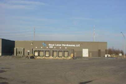
Property Detail
899 Interchange Dr
53-02-10-400-016
PART OF SE 1/4 BEING DESC AS: COMM AT SE COR OF SD SEC; TH N 00 DEGREES 38' 01 W 445.36 FT ALG THE E LI OF SD SEC; TH N 88
Warehouse
ALLEGAN
B and X Area of moderate flood hazard, usually the area between the limits of the 100-year and 500-year floods.
Michigan
2025
28.34 AC
2026
Outlying Allegan County
032401
West Michigan
391,842 SF
Holland, MI
NEARBY LISTINGS FOR SALE OR LEASE
DEMOGRAPHICS near 899 Interchange Dr
1 mile
3 mile
5 mile
2025 Total Population
878
16,786
55,044
2030 Population
903
17,002
55,898
Pop Growth 2025-2030
+ 2.85%
+ 1.29%
+ 1.55%
Average Age
38
41
40
2025 Total Households
327
6,499
20,644
HH Growth 2025-2030
+ 2.75%
+ 1.29%
+ 1.66%
Median Household Inc
$78,409
$74,206
$74,354
Avg Household Size
2.70
2.40
2.50
2025 Avg HH Vehicles
2.00
2.00
2.00
Median Home Value
$243,038
$263,242
$277,760
Median Year Built
1988
1979
1976
Nearby Places
Map Layers
Map Styles
 Street
 Aerial
Layers
 Traffic
 Biking
Places
Listings with unknown addresses are not visible on the map
- Restaurants
- Banks
- Shops
- Fitness
- Groceries
PUBLIC TRANSPORTATION
COMMUTER RAIL
Holland Amtrak Station (Pere Marquette - Amtrak)
Drive
Walk
Distance
Holland Amtrak Station (Pere Marquette - Amtrak)
10 min
5.0 mi
AIRPORT
Gerald R Ford International
Drive
Walk
Distance
Gerald R Ford International
44 min
34.5 mi
Freight Ports
Port Milwaukee
Drive
Walk
Distance
Port Milwaukee
276 min
235.5 mi
Nearby Properties
Address
Land Use
TOTAL SIZE
Lot Size
Zoning
Address
Land Use
TOTAL SIZE
Lot Size
Zoning
1,599,294 SF
Address
Land Use
TOTAL SIZE
Lot Size
Zoning
1,788,352 SF
173.33 AC
Address
Land Use
TOTAL SIZE
Lot Size
Zoning
669,408 SF
99.60 AC
I
Address
Land Use
TOTAL SIZE
Lot Size
Zoning
198,712 SF
Address
Land Use
TOTAL SIZE
Lot Size
Zoning
557,392 SF
28.50 AC
Address
Land Use
TOTAL SIZE
Lot Size
Zoning
556,819 SF
85.45 AC
Address
Land Use
TOTAL SIZE
Lot Size
Zoning
245,093 SF
10.70 AC
PUD
Address
Land Use
TOTAL SIZE
Lot Size
Zoning
249,051 SF
15.59 AC
HDR
Address
Land Use
TOTAL SIZE
Lot Size
Zoning
218,722 SF
8.59 AC
PUD
Address
Land Use
TOTAL SIZE
Lot Size
Zoning
674,052 SF
79.30 AC
Address
Land Use
TOTAL SIZE
Lot Size
Zoning
154,107 SF
Address
Land Use
TOTAL SIZE
Lot Size
Zoning
239,465 SF
Address
Land Use
TOTAL SIZE
Lot Size
Zoning
589,649 SF
92.65 AC
Address
Land Use
TOTAL SIZE
Lot Size
Zoning
150,822 SF
Address
Land Use
TOTAL SIZE
Lot Size
Zoning
118,444 SF
4.39 AC
Address
Land Use
TOTAL SIZE
Lot Size
Zoning
181,754 SF
13.44 AC
R3
Address
Land Use
TOTAL SIZE
Lot Size
Zoning
357,000 SF
23.35 AC
Address
Land Use
TOTAL SIZE
Lot Size
Zoning
73,700 SF
Address
Land Use
TOTAL SIZE
Lot Size
Zoning
228,876 SF
49.31 AC
GMU
Address
Land Use
TOTAL SIZE
Lot Size
Zoning
397,258 SF
36.66 AC
I2
Address
Land Use
TOTAL SIZE
Lot Size
Zoning
158,661 SF
17.28 AC
Address
Land Use
TOTAL SIZE
Lot Size
Zoning
146,357 SF
20.04 AC
Address
Land Use
TOTAL SIZE
Lot Size
Zoning
73,663 SF
4.66 AC
Address
Land Use
TOTAL SIZE
Lot Size
Zoning
151,722 SF
14.19 AC
HDR
Address
Land Use
TOTAL SIZE
Lot Size
Zoning
252,065 SF
13.98 AC
Address
Land Use
TOTAL SIZE
Lot Size
Zoning
404,600 SF
23.23 AC
I2
Address
Land Use
TOTAL SIZE
Lot Size
Zoning
84,746 SF
8.04 AC
HDR
Address
Land Use
TOTAL SIZE
Lot Size
Zoning
281,775 SF
Address
Land Use
TOTAL SIZE
Lot Size
Zoning
55,088 SF
The World's #1 Commercial Real Estate Marketplace
Connect with us
© 2026 CoStar Group
The information above has been obtained from sources believed reliable. While we do not doubt its accuracy we have not verified it and make no guarantee, warranty or representation about it. It is your responsibility to independently confirm its accuracy and completeness. Any projections, opinions, assumptions, or estimates used are for example only and do not represent the current or future performance of the property. The value of this transaction to you depends on tax and other factors which should be evaluated by your tax, financial, and legal advisors. You and your advisors should conduct a careful, independent investigation of the property to determine to your satisfaction the suitability of the property for your needs.