Property Record
875 Straus Rd, Cedar Hill, TX 75104

Current Lease Availabilities
NEARBY LISTINGS FOR SALE OR LEASE
Property Detail
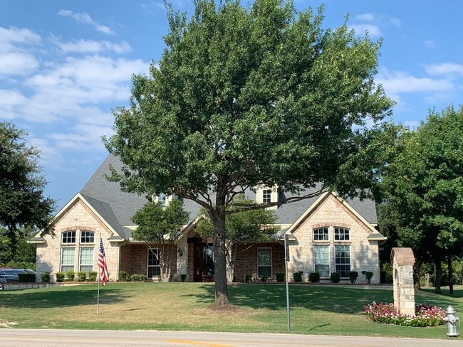
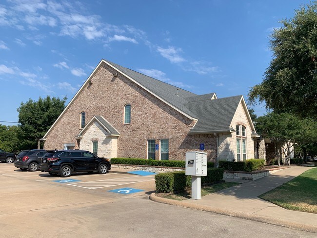
875 Straus Rd
Dallas-Fort Worth-Arlington, TX
Clark-Patton
160156500A0010000
CLARK-PATTON BLK A LT 1 ACS 0.6171 VOL2002095/6827 DD05072002 CO-DC 0156500A00100 4CH0156500A
Officebuilding
Dallas
X
Texas
48139C0030G
1
2024
0.62 AC
2025
Southwest Dallas
016522
Dallas/Ft Worth
7,377 SF
DEMOGRAPHICS near 875 Straus Rd
1 Mile
3 Mile
5 Mile
2024 Total Population
7,877
57,829
127,682
2029 Population
7,909
56,969
126,197
Pop Growth 2024-2029
+ 0.41%
(1.49%)
(1.16%)
Average Age
39
38
38
2024 Total Households
2,874
19,234
42,542
HH Growth 2024-2029
+ 0.45%
(1.65%)
(1.34%)
Median Household Inc
$61,998
$75,799
$74,711
Avg Household Size
2.70
2.90
2.90
2024 Avg HH Vehicles
2.00
2.00
2.00
Median Home Value
$200,798
$233,470
$242,095
Median Year Built
1996
1989
1990
Nearby Places
Map Layers
Map Styles
 Street
 Aerial
- Restaurants
- Banks
- Shops
- Fitness
- Groceries
PUBLIC TRANSPORTATION
AIRPORT
Dallas Love Field
DRIVE
WALK
Distance
Dallas Love Field
32 min
21.9 mi
Dallas-Fort Worth International
DRIVE
WALK
Distance
Dallas-Fort Worth International
35 min
25.8 mi
Freight Ports
Port of Shreveport
DRIVE
WALK
Distance
Port of Shreveport
222 min
206.4 mi
Nearby Properties
Address
Land Use
TOTAL SIZE
Lot Size
Zoning
Address
Land Use
TOTAL SIZE
Lot Size
Zoning
446,164 SF
13.45 AC
Z137
Address
Land Use
TOTAL SIZE
Lot Size
Zoning
494,366 SF
43.30 AC
Z137
Address
Land Use
TOTAL SIZE
Lot Size
Zoning
374,277 SF
17.41 AC
Z137
Address
Land Use
TOTAL SIZE
Lot Size
Zoning
217,510 SF
67.57 AC
Z268
Address
Land Use
TOTAL SIZE
Lot Size
Zoning
248,819 SF
92.33 AC
AA1
Address
Land Use
TOTAL SIZE
Lot Size
Zoning
0.05 AC
Z109
Address
Land Use
TOTAL SIZE
Lot Size
Zoning
219,128 SF
11.62 AC
Z160
Address
Land Use
TOTAL SIZE
Lot Size
Zoning
219,152 SF
14.31 AC
Z160
Address
Land Use
TOTAL SIZE
Lot Size
Zoning
188,600 SF
13.52 AC
Z160
Address
Land Use
TOTAL SIZE
Lot Size
Zoning
115,000 SF
15.89 AC
Z137
Address
Land Use
TOTAL SIZE
Lot Size
Zoning
223,899 SF
10 AC
Z160
Address
Land Use
TOTAL SIZE
Lot Size
Zoning
168,476 SF
8.15 AC
Z137
Address
Land Use
TOTAL SIZE
Lot Size
Zoning
299,986 SF
26.32 AC
Z137
Address
Land Use
TOTAL SIZE
Lot Size
Zoning
176,010 SF
16.72 AC
Z137
Address
Land Use
TOTAL SIZE
Lot Size
Zoning
347,760 SF
21.61 AC
Z109
Address
Land Use
TOTAL SIZE
Lot Size
Zoning
174,708 SF
9.78 AC
Z360
Address
Land Use
TOTAL SIZE
Lot Size
Zoning
308,880 SF
19.03 AC
Z109
Address
Land Use
TOTAL SIZE
Lot Size
Zoning
118,617 SF
23.20 AC
Z360
Address
Land Use
TOTAL SIZE
Lot Size
Zoning
321,600 SF
19.58 AC
Z109
Address
Land Use
TOTAL SIZE
Lot Size
Zoning
148,971 SF
15.11 AC
Z137
Address
Land Use
TOTAL SIZE
Lot Size
Zoning
135,000 SF
23.91 AC
Z360
Address
Land Use
TOTAL SIZE
Lot Size
Zoning
156,000 SF
11.31 AC
Z14
Address
Land Use
TOTAL SIZE
Lot Size
Zoning
30,926 SF
109.20 AC
AA1
Address
Land Use
TOTAL SIZE
Lot Size
Zoning
42,218 SF
10.03 AC
Z137
Address
Land Use
TOTAL SIZE
Lot Size
Zoning
223,789 SF
25.66 AC
Z137
Address
Land Use
TOTAL SIZE
Lot Size
Zoning
123,120 SF
10.02 AC
Z109
Address
Land Use
TOTAL SIZE
Lot Size
Zoning
143,331 SF
12.74 AC
Z363
Address
Land Use
TOTAL SIZE
Lot Size
Zoning
72,530 SF
19.58 AC
Z360
Address
Land Use
TOTAL SIZE
Lot Size
Zoning
123,162 SF
61.28 AC
Z369
Address
Land Use
TOTAL SIZE
Lot Size
Zoning
51,136 SF
15.60 AC
Z31
The World's #1 Commercial Real Estate Marketplace
Connect with us
© 2025 CoStar Group
The information above has been obtained from sources believed reliable. While we do not doubt its accuracy we have not verified it and make no guarantee, warranty or representation about it. It is your responsibility to independently confirm its accuracy and completeness. Any projections, opinions, assumptions, or estimates used are for example only and do not represent the current or future performance of the property. The value of this transaction to you depends on tax and other factors which should be evaluated by your tax, financial, and legal advisors. You and your advisors should conduct a careful, independent investigation of the property to determine to your satisfaction the suitability of the property for your needs.