Property Record
875 W Saint Johns Ct, Crete, NE 68333

NEARBY LISTINGS FOR SALE OR LEASE
Property Detail
875 W Saint Johns Ct
Chico, CA
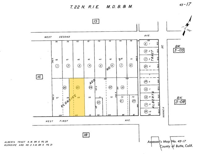
Klondike Add 03
043-170-025-000
646 & 666 W 1ST AVE
Multifamilydwelling
Butte
X
California
06007C0505E
68,69
2024
0.63 AC
2025
Redding/Chico
000700
Other Market Areas
8,846 SF
DEMOGRAPHICS near 875 W Saint Johns Ct
1 Mile
3 Mile
5 Mile
2024 Total Population
20,588
82,446
104,889
2029 Population
19,621
78,704
100,306
Pop Growth 2024-2029
(4.70%)
(4.54%)
(4.37%)
Average Age
30
36
37
2024 Total Households
7,787
33,781
42,864
HH Growth 2024-2029
(4.93%)
(4.74%)
(4.57%)
Median Household Inc
$44,011
$63,996
$68,705
Avg Household Size
2.30
2.30
2.30
2024 Avg HH Vehicles
2.00
2.00
2.00
Median Home Value
$406,522
$396,954
$426,047
Median Year Built
1977
1978
1982
Nearby Places
Map Layers
Map Styles
 Street
 Aerial
- Restaurants
- Banks
- Shops
- Fitness
- Groceries
PUBLIC TRANSPORTATION
COMMUTER RAIL
Chico Amtrak (Coast Starlight - Amtrak)
DRIVE
WALK
Distance
Chico Amtrak (Coast Starlight - Amtrak)
4 min
1.4 mi
Freight Ports
Port of Stockton
DRIVE
WALK
Distance
Port of Stockton
163 min
133.2 mi
Nearby Properties
Address
Land Use
TOTAL SIZE
Lot Size
Zoning
Address
Land Use
TOTAL SIZE
Lot Size
Zoning
150,000 SF
2.31 AC
Address
Land Use
TOTAL SIZE
Lot Size
Zoning
135,668 SF
3.43 AC
PQ
Address
Land Use
TOTAL SIZE
Lot Size
Zoning
194,612 SF
4.72 AC
R3
Address
Land Use
TOTAL SIZE
Lot Size
Zoning
8.55 AC
R3
Address
Land Use
TOTAL SIZE
Lot Size
Zoning
90,859 SF
5.60 AC
PQ
Address
Land Use
TOTAL SIZE
Lot Size
Zoning
84,280 SF
1.60 AC
R4
Address
Land Use
TOTAL SIZE
Lot Size
Zoning
8,008 SF
8.79 AC
Address
Land Use
TOTAL SIZE
Lot Size
Zoning
126,476 SF
6.75 AC
R3
Address
Land Use
TOTAL SIZE
Lot Size
Zoning
133,120 SF
5.37 AC
R3
Address
Land Use
TOTAL SIZE
Lot Size
Zoning
1,189 SF
1.25 AC
A40
Address
Land Use
TOTAL SIZE
Lot Size
Zoning
61,571 SF
6.47 AC
Address
Land Use
TOTAL SIZE
Lot Size
Zoning
158,426 SF
16.19 AC
M1
Address
Land Use
TOTAL SIZE
Lot Size
Zoning
1.58 AC
Address
Land Use
TOTAL SIZE
Lot Size
Zoning
247,613 SF
10.77 AC
CR
Address
Land Use
TOTAL SIZE
Lot Size
Zoning
160,354 SF
11.39 AC
00
Address
Land Use
TOTAL SIZE
Lot Size
Zoning
175,392 SF
14.83 AC
Address
Land Use
TOTAL SIZE
Lot Size
Zoning
16,020 SF
12.01 AC
Address
Land Use
TOTAL SIZE
Lot Size
Zoning
83,886 SF
4.55 AC
Address
Land Use
TOTAL SIZE
Lot Size
Zoning
142,712 SF
7.24 AC
Address
Land Use
TOTAL SIZE
Lot Size
Zoning
44,492 SF
2.05 AC
R3
Address
Land Use
TOTAL SIZE
Lot Size
Zoning
92,292 SF
5.14 AC
Address
Land Use
TOTAL SIZE
Lot Size
Zoning
137,980 SF
15 AC
Address
Land Use
TOTAL SIZE
Lot Size
Zoning
18,809 SF
13.55 AC
Address
Land Use
TOTAL SIZE
Lot Size
Zoning
3.30 AC
CR
Address
Land Use
TOTAL SIZE
Lot Size
Zoning
24.26 AC
Address
Land Use
TOTAL SIZE
Lot Size
Zoning
115,792 SF
5.69 AC
R3
Address
Land Use
TOTAL SIZE
Lot Size
Zoning
2,248 SF
7.90 AC
R3
Address
Land Use
TOTAL SIZE
Lot Size
Zoning
90,400 SF
7.50 AC
Address
Land Use
TOTAL SIZE
Lot Size
Zoning
105,390 SF
8.13 AC
Address
Land Use
TOTAL SIZE
Lot Size
Zoning
125,873 SF
11.32 AC
The World's #1 Commercial Real Estate Marketplace
Connect with us
© 2026 CoStar Group
The information above has been obtained from sources believed reliable. While we do not doubt its accuracy we have not verified it and make no guarantee, warranty or representation about it. It is your responsibility to independently confirm its accuracy and completeness. Any projections, opinions, assumptions, or estimates used are for example only and do not represent the current or future performance of the property. The value of this transaction to you depends on tax and other factors which should be evaluated by your tax, financial, and legal advisors. You and your advisors should conduct a careful, independent investigation of the property to determine to your satisfaction the suitability of the property for your needs.