Property Record
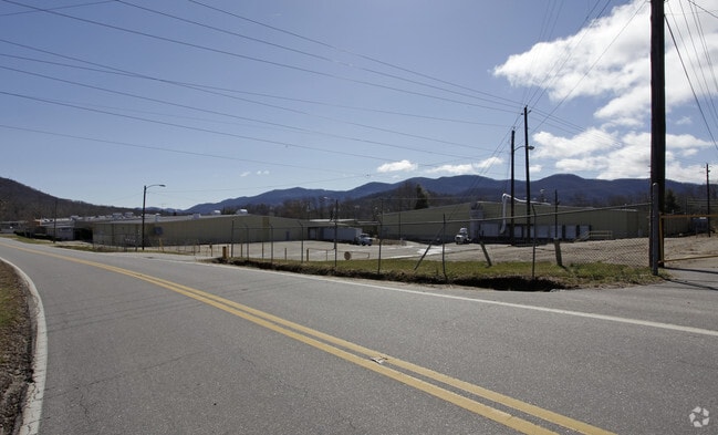
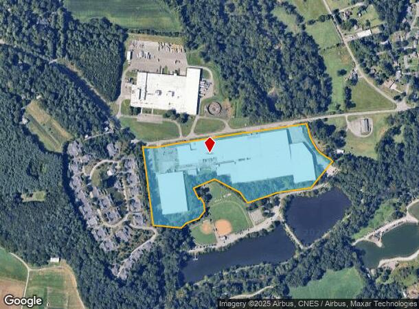
875 Warren Wilson Rd, Swannanoa, NC 28778
NEARBY LISTINGS FOR SALE OR LEASE
-
-
View all Swannanoa listings for sale on LoopNet.com
Property Detail
875 Warren Wilson Rd
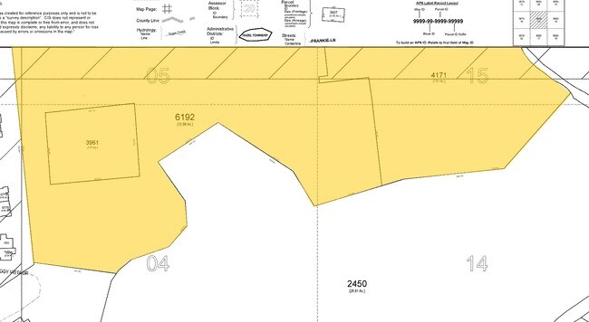
9689-05-9002-00000
SUBDIV: BLOCK: LOT: SECTION: PLAT: 0146-0193
Industrialgeneral
Buncombe
AE
North Carolina
3700968900J
22.50 AC
0
Buncombe County
2025
Asheville
003002
Asheville, NC
492,052 SF
DEMOGRAPHICS near 875 Warren Wilson Rd
1 Mile
3 Mile
5 Mile
2024 Total Population
2,214
14,983
32,405
2029 Population
2,319
15,613
33,644
Pop Growth 2024-2029
+ 4.74%
+ 4.20%
+ 3.82%
Average Age
43
44
45
2024 Total Households
871
6,257
13,991
HH Growth 2024-2029
+ 4.36%
+ 3.68%
+ 3.27%
Median Household Inc
$59,249
$60,274
$65,341
Avg Household Size
2.30
2.30
2.20
2024 Avg HH Vehicles
2.00
2.00
2.00
Median Home Value
$284,848
$252,819
$316,148
Median Year Built
1984
1986
1987
Nearby Places
Map Layers
Map Styles
 Street
 Aerial
- Restaurants
- Banks
- Shops
- Fitness
- Groceries
PUBLIC TRANSPORTATION
AIRPORT
Asheville Regional
DRIVE
WALK
Distance
Asheville Regional
30 min
17.6 mi
Freight Ports
North Charleston Terminal
DRIVE
WALK
Distance
North Charleston Terminal
302 min
261.3 mi
Nearby Properties
Address
Land Use
TOTAL SIZE
Lot Size
Zoning
Address
Land Use
TOTAL SIZE
Lot Size
Zoning
323,429 SF
1,005.50 AC
PS
Address
Land Use
TOTAL SIZE
Lot Size
Zoning
93,360 SF
12.51 AC
PS
Address
Land Use
TOTAL SIZE
Lot Size
Zoning
44,450 SF
8.97 AC
PS
Address
Land Use
TOTAL SIZE
Lot Size
Zoning
1,262 SF
3,958.36 AC
OU
Address
Land Use
TOTAL SIZE
Lot Size
Zoning
33,037 SF
5.80 AC
RIVER
Address
Land Use
TOTAL SIZE
Lot Size
Zoning
26,618 SF
2.88 AC
HB
Address
Land Use
TOTAL SIZE
Lot Size
Zoning
8,260 SF
2.03 AC
LODG EXP
Address
Land Use
TOTAL SIZE
Lot Size
Zoning
20,158 SF
3.27 AC
HB
Address
Land Use
TOTAL SIZE
Lot Size
Zoning
38.41 AC
EMP
Address
Land Use
TOTAL SIZE
Lot Size
Zoning
68,648 SF
7.87 AC
CS
Address
Land Use
TOTAL SIZE
Lot Size
Zoning
35,199 SF
3 AC
CS
Address
Land Use
TOTAL SIZE
Lot Size
Zoning
27,840 SF
4.29 AC
NS
Address
Land Use
TOTAL SIZE
Lot Size
Zoning
13,766 SF
2.17 AC
HB
Address
Land Use
TOTAL SIZE
Lot Size
Zoning
213,584 SF
37.91 AC
EMP
Address
Land Use
TOTAL SIZE
Lot Size
Zoning
15,169 SF
29.38 AC
R-2
Address
Land Use
TOTAL SIZE
Lot Size
Zoning
28,893 SF
3.61 AC
R-1
Address
Land Use
TOTAL SIZE
Lot Size
Zoning
152,109 SF
6.02 AC
CS
Address
Land Use
TOTAL SIZE
Lot Size
Zoning
33,722 SF
8.80 AC
CS
Address
Land Use
TOTAL SIZE
Lot Size
Zoning
12,840 SF
3.78 AC
R-3
Address
Land Use
TOTAL SIZE
Lot Size
Zoning
12,902 SF
131.65 AC
OU
Address
Land Use
TOTAL SIZE
Lot Size
Zoning
13,759 SF
10 AC
R-2
Address
Land Use
TOTAL SIZE
Lot Size
Zoning
17,507 SF
1.81 AC
R-3
Address
Land Use
TOTAL SIZE
Lot Size
Zoning
8,743 SF
4.33 AC
R-1
Address
Land Use
TOTAL SIZE
Lot Size
Zoning
30,374 SF
3.31 AC
CS
Address
Land Use
TOTAL SIZE
Lot Size
Zoning
38,043 SF
2.33 AC
NS
Address
Land Use
TOTAL SIZE
Lot Size
Zoning
7,680 SF
3.68 AC
PS
Address
Land Use
TOTAL SIZE
Lot Size
Zoning
13,260 SF
1.87 AC
CS
Address
Land Use
TOTAL SIZE
Lot Size
Zoning
7,941 SF
3.24 AC
NS
Address
Land Use
TOTAL SIZE
Lot Size
Zoning
31,830 SF
3.99 AC
CS
The World's #1 Commercial Real Estate Marketplace
Connect with us
© 2026 CoStar Group
The information above has been obtained from sources believed reliable. While we do not doubt its accuracy we have not verified it and make no guarantee, warranty or representation about it. It is your responsibility to independently confirm its accuracy and completeness. Any projections, opinions, assumptions, or estimates used are for example only and do not represent the current or future performance of the property. The value of this transaction to you depends on tax and other factors which should be evaluated by your tax, financial, and legal advisors. You and your advisors should conduct a careful, independent investigation of the property to determine to your satisfaction the suitability of the property for your needs.