Property Record
8752 N State Highway 83, Parker, CO 80134
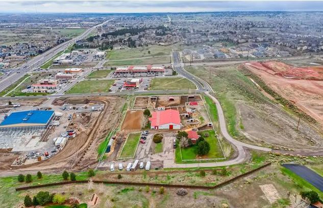
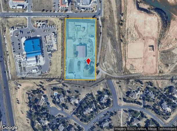
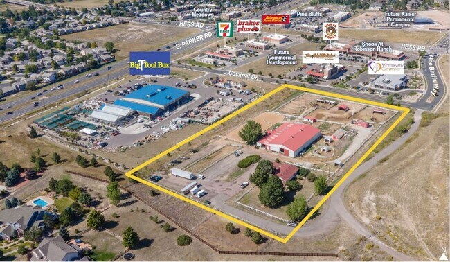
This Property Is For Sale
NEARBY LISTINGS FOR SALE OR LEASE
Property Detail
8752 N State Highway 83
Denver-Aurora-Centennial, CO
Metes And Bounds
2233-341-00-030
Douglas
Sfr
Colorado
X
4.74 AC
08035C0182G
Parker/Castle Rock
1,368 SF
Denver
DEMOGRAPHICS near 8752 N State Highway 83
1 Mile
3 Mile
5 Mile
2024 Total Population
8,184
55,058
107,077
2029 Population
9,277
62,441
121,877
Pop Growth 2024-2029
+ 13.36%
+ 13.41%
+ 13.82%
Average Age
39
38
38
2024 Total Households
3,025
18,866
37,482
HH Growth 2024-2029
+ 13.62%
+ 13.50%
+ 13.97%
Median Household Inc
$126,740
$133,998
$132,967
Avg Household Size
2.70
2.90
2.80
2024 Avg HH Vehicles
2.00
2.00
2.00
Median Home Value
$487,940
$604,042
$646,225
Median Year Built
2000
2001
2002
Nearby Places
Map Layers
Map Styles
 Street
 Aerial
- Restaurants
- Banks
- Shops
- Fitness
- Groceries
PUBLIC TRANSPORTATION
AIRPORT
Denver International
DRIVE
WALK
Distance
Denver International
37 min
32.3 mi
Freight Ports
Tulsa Port Of Catoosa
DRIVE
WALK
Distance
Tulsa Port Of Catoosa
729 min
689.2 mi
Nearby Properties
Address
Land Use
TOTAL SIZE
Lot Size
Zoning
Address
Land Use
TOTAL SIZE
Lot Size
Zoning
234,588 SF
46.71 AC
A1
Address
Land Use
TOTAL SIZE
Lot Size
Zoning
132,400 SF
26.15 AC
Address
Land Use
TOTAL SIZE
Lot Size
Zoning
132,601 SF
16.08 AC
Address
Land Use
TOTAL SIZE
Lot Size
Zoning
343,018 SF
15.13 AC
Address
Land Use
TOTAL SIZE
Lot Size
Zoning
344,128 SF
19.06 AC
Address
Land Use
TOTAL SIZE
Lot Size
Zoning
453,901 SF
16.34 AC
Address
Land Use
TOTAL SIZE
Lot Size
Zoning
93,100 SF
8.95 AC
Address
Land Use
TOTAL SIZE
Lot Size
Zoning
132,601 SF
16.05 AC
Address
Land Use
TOTAL SIZE
Lot Size
Zoning
514,882 SF
18.63 AC
Address
Land Use
TOTAL SIZE
Lot Size
Zoning
72,346 SF
8.02 AC
Address
Land Use
TOTAL SIZE
Lot Size
Zoning
138,348 SF
14.96 AC
RR
Address
Land Use
TOTAL SIZE
Lot Size
Zoning
369,624 SF
21.98 AC
Address
Land Use
TOTAL SIZE
Lot Size
Zoning
307,904 SF
15.72 AC
Address
Land Use
TOTAL SIZE
Lot Size
Zoning
79,907 SF
7.52 AC
Address
Land Use
TOTAL SIZE
Lot Size
Zoning
73,146 SF
6.91 AC
Address
Land Use
TOTAL SIZE
Lot Size
Zoning
302,161 SF
11.02 AC
Address
Land Use
TOTAL SIZE
Lot Size
Zoning
55,860 SF
9.95 AC
RR
Address
Land Use
TOTAL SIZE
Lot Size
Zoning
56,868 SF
10.01 AC
Address
Land Use
TOTAL SIZE
Lot Size
Zoning
175,917 SF
12.88 AC
Address
Land Use
TOTAL SIZE
Lot Size
Zoning
208,495 SF
19.59 AC
Address
Land Use
TOTAL SIZE
Lot Size
Zoning
41,273 SF
5.70 AC
Address
Land Use
TOTAL SIZE
Lot Size
Zoning
50,000 SF
8.60 AC
Address
Land Use
TOTAL SIZE
Lot Size
Zoning
76,482 SF
4 AC
Address
Land Use
TOTAL SIZE
Lot Size
Zoning
86,539 SF
9.30 AC
Address
Land Use
TOTAL SIZE
Lot Size
Zoning
34,935 SF
3.75 AC
Address
Land Use
TOTAL SIZE
Lot Size
Zoning
49,060 SF
9 AC
Address
Land Use
TOTAL SIZE
Lot Size
Zoning
37,163 SF
2.19 AC
Address
Land Use
TOTAL SIZE
Lot Size
Zoning
50,237 SF
14.11 AC
Address
Land Use
TOTAL SIZE
Lot Size
Zoning
51,974 SF
6.87 AC
A1
Address
Land Use
TOTAL SIZE
Lot Size
Zoning
51,373 SF
13.74 AC
The World's #1 Commercial Real Estate Marketplace
Connect with us
© 2026 CoStar Group
The information above has been obtained from sources believed reliable. While we do not doubt its accuracy we have not verified it and make no guarantee, warranty or representation about it. It is your responsibility to independently confirm its accuracy and completeness. Any projections, opinions, assumptions, or estimates used are for example only and do not represent the current or future performance of the property. The value of this transaction to you depends on tax and other factors which should be evaluated by your tax, financial, and legal advisors. You and your advisors should conduct a careful, independent investigation of the property to determine to your satisfaction the suitability of the property for your needs.