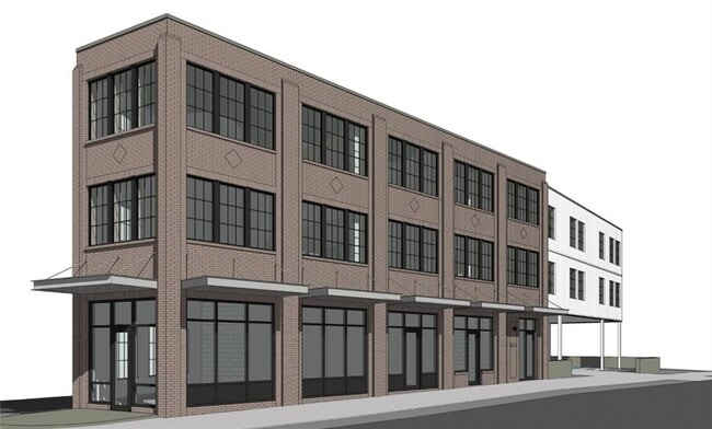
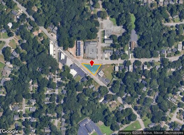
Property Record
876 Bouldercrest Dr Se, Atlanta, GA 30316
NEARBY LISTINGS FOR SALE OR LEASE
Property Detail
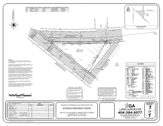
876 Bouldercrest Dr Se
15-146-12-040
DeKalb
Commercialacreage
Georgia
X
1
13089C0127J
0.33 AC
2025
I-20 East/Conyers
2025
Atlanta
020902
Atlanta-Sandy Springs-Roswell, GA
DEMOGRAPHICS near 876 Bouldercrest Dr Se
1 Mile
3 Mile
5 Mile
2024 Total Population
11,614
120,577
336,920
2029 Population
11,650
123,510
345,069
Pop Growth 2024-2029
+ 0.31%
+ 2.43%
+ 2.42%
Average Age
39
37
37
2024 Total Households
5,129
54,255
148,144
HH Growth 2024-2029
+ 0.29%
+ 2.63%
+ 2.72%
Median Household Inc
$89,234
$90,606
$79,727
Avg Household Size
2.20
2.10
2.00
2024 Avg HH Vehicles
2.00
1.00
1.00
Median Home Value
$391,877
$443,262
$425,351
Median Year Built
1958
1974
1982
Nearby Places
Map Layers
Map Styles
 Street
 Aerial
- Restaurants
- Banks
- Shops
- Fitness
- Groceries
PUBLIC TRANSPORTATION
COMMUTER RAIL
Atlanta (Crescent - Amtrak)
DRIVE
WALK
Distance
Atlanta (Crescent - Amtrak)
14 min
7.3 mi
AIRPORT
Hartsfield - Jackson Atlanta International
DRIVE
WALK
Distance
Hartsfield - Jackson Atlanta International
22 min
12.8 mi
Freight Ports
Georgia Ports - Savannah
DRIVE
WALK
Distance
Georgia Ports - Savannah
278 min
245.4 mi
SALE & LEASE HISTORY
LISTING DATE
SALE/LEASE

May 01, 2024
For Sale
Nearby Properties
Address
Land Use
TOTAL SIZE
Lot Size
Zoning
Address
Land Use
TOTAL SIZE
Lot Size
Zoning
543,748 SF
3.86 AC
I2
Address
Land Use
TOTAL SIZE
Lot Size
Zoning
1,975,400 SF
9.58 AC
RG4
Address
Land Use
TOTAL SIZE
Lot Size
Zoning
432,056 SF
17.87 AC
C1
Address
Land Use
TOTAL SIZE
Lot Size
Zoning
400,311 SF
4.45 AC
I2
Address
Land Use
TOTAL SIZE
Lot Size
Zoning
498,515 SF
3.41 AC
C1
Address
Land Use
TOTAL SIZE
Lot Size
Zoning
595,658 SF
4.09 AC
I1
Address
Land Use
TOTAL SIZE
Lot Size
Zoning
959,348 SF
7.28 AC
PDMU
Address
Land Use
TOTAL SIZE
Lot Size
Zoning
543,551 SF
5.26 AC
R4
Address
Land Use
TOTAL SIZE
Lot Size
Zoning
94.93 AC
R5
Address
Land Use
TOTAL SIZE
Lot Size
Zoning
290,130 SF
6.13 AC
R100
Address
Land Use
TOTAL SIZE
Lot Size
Zoning
397,758 SF
1.91 AC
I1
Address
Land Use
TOTAL SIZE
Lot Size
Zoning
566,872 SF
3.31 AC
I1
Address
Land Use
TOTAL SIZE
Lot Size
Zoning
369,356 SF
2.50 AC
I1
Address
Land Use
TOTAL SIZE
Lot Size
Zoning
67,882 SF
4.77 AC
X
Address
Land Use
TOTAL SIZE
Lot Size
Zoning
491,862 SF
2.44 AC
R4
Address
Land Use
TOTAL SIZE
Lot Size
Zoning
528,810 SF
3.61 AC
I2
Address
Land Use
TOTAL SIZE
Lot Size
Zoning
624,087 SF
4.45 AC
I2
Address
Land Use
TOTAL SIZE
Lot Size
Zoning
436,143 SF
2.90 AC
I1
Address
Land Use
TOTAL SIZE
Lot Size
Zoning
330,125 SF
7.16 AC
I1
Address
Land Use
TOTAL SIZE
Lot Size
Zoning
390,107 SF
4.98 AC
C1
Address
Land Use
TOTAL SIZE
Lot Size
Zoning
438,163 SF
4.45 AC
R5
Address
Land Use
TOTAL SIZE
Lot Size
Zoning
283,235 SF
5 AC
RG4
Address
Land Use
TOTAL SIZE
Lot Size
Zoning
363,464 SF
2.92 AC
I2
Address
Land Use
TOTAL SIZE
Lot Size
Zoning
348,894 SF
0.58 AC
I1
Address
Land Use
TOTAL SIZE
Lot Size
Zoning
400,347 SF
3.30 AC
I2
Address
Land Use
TOTAL SIZE
Lot Size
Zoning
334,127 SF
0.01 AC
X
Address
Land Use
TOTAL SIZE
Lot Size
Zoning
335,050 SF
12.90 AC
X
Address
Land Use
TOTAL SIZE
Lot Size
Zoning
444,229 SF
2.76 AC
I1
Address
Land Use
TOTAL SIZE
Lot Size
Zoning
828,718 SF
2.60 AC
I1
Address
Land Use
TOTAL SIZE
Lot Size
Zoning
338,702 SF
5.65 AC
I2
The World's #1 Commercial Real Estate Marketplace
Connect with us
© 2026 CoStar Group
The information above has been obtained from sources believed reliable. While we do not doubt its accuracy we have not verified it and make no guarantee, warranty or representation about it. It is your responsibility to independently confirm its accuracy and completeness. Any projections, opinions, assumptions, or estimates used are for example only and do not represent the current or future performance of the property. The value of this transaction to you depends on tax and other factors which should be evaluated by your tax, financial, and legal advisors. You and your advisors should conduct a careful, independent investigation of the property to determine to your satisfaction the suitability of the property for your needs.