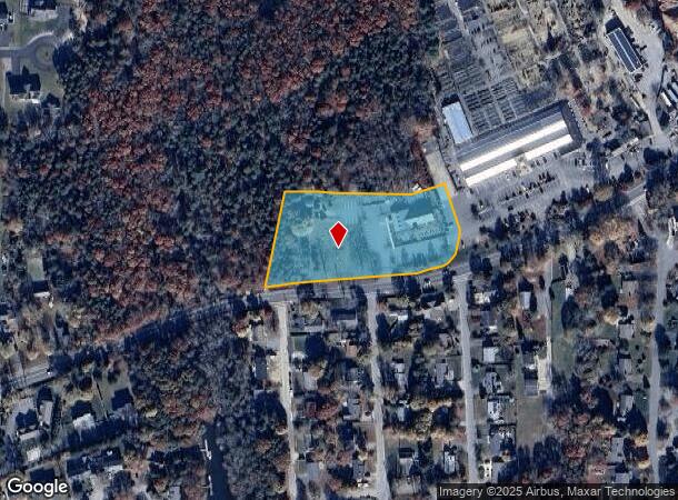
Property Record
876 E Falmouth Hwy, East Falmouth, MA 02536
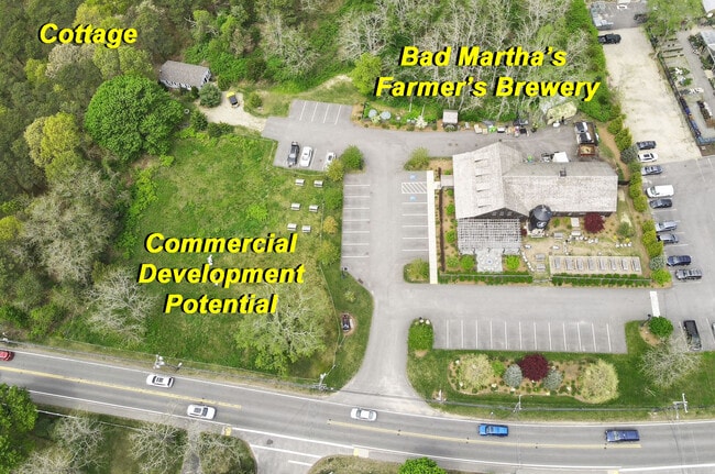
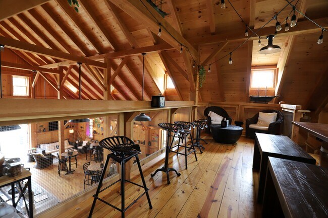
This Property Is For Sale
NEARBY LISTINGS FOR SALE OR LEASE
Property Detail
876 E Falmouth Hwy
FALM-000032-000005-000001A-000002
Barnstable
Commercialofficeresidentialmixeduse
Massachusetts
X
2
25001C0733J
2.37 AC
2025
Cape Cod
2025
Other Market Areas
014600
Barnstable Town, MA
6,791 SF
DEMOGRAPHICS near 876 E Falmouth Hwy
1 Mile
3 Mile
5 Mile
2024 Total Population
4,052
21,006
40,941
2029 Population
4,404
22,587
43,891
Pop Growth 2024-2029
+ 8.69%
+ 7.53%
+ 7.21%
Average Age
49
50
51
2024 Total Households
1,811
9,397
19,082
HH Growth 2024-2029
+ 8.67%
+ 7.62%
+ 7.23%
Median Household Inc
$66,128
$80,824
$84,261
Avg Household Size
2.20
2.20
2.10
2024 Avg HH Vehicles
2.00
2.00
2.00
Median Home Value
$460,135
$464,285
$495,384
Median Year Built
1975
1977
1980
Nearby Places
- Restaurants
- Banks
- Shops
- Fitness
- Groceries
PUBLIC TRANSPORTATION
AIRPORT
Martha's Vineyard
DRIVE
WALK
Distance
Martha's Vineyard
79 min
22.7 mi
Nantucket Memorial
DRIVE
WALK
Distance
Nantucket Memorial
176 min
49.4 mi
Freight Ports
Port of New Bedford Harbor
DRIVE
WALK
Distance
Port of New Bedford Harbor
59 min
41.7 mi
Nearby Properties
Address
Land Use
TOTAL SIZE
Lot Size
Zoning
Address
Land Use
TOTAL SIZE
Lot Size
Zoning
287 AC
R3
Address
Land Use
TOTAL SIZE
Lot Size
Zoning
276,514 SF
38.06 AC
B2
Address
Land Use
TOTAL SIZE
Lot Size
Zoning
333.20 AC
RA
Address
Land Use
TOTAL SIZE
Lot Size
Zoning
59,880 SF
18.39 AC
PU
Address
Land Use
TOTAL SIZE
Lot Size
Zoning
56,592 SF
16.62 AC
PU
Address
Land Use
TOTAL SIZE
Lot Size
Zoning
41,386 SF
7.59 AC
AGA
Address
Land Use
TOTAL SIZE
Lot Size
Zoning
3,000 SF
260.39 AC
PU
Address
Land Use
TOTAL SIZE
Lot Size
Zoning
88,720 SF
4.20 AC
LIA
Address
Land Use
TOTAL SIZE
Lot Size
Zoning
19.70 AC
Address
Land Use
TOTAL SIZE
Lot Size
Zoning
37,008 SF
8.13 AC
AGB
Address
Land Use
TOTAL SIZE
Lot Size
Zoning
6,168 SF
8.13 AC
AGB
Address
Land Use
TOTAL SIZE
Lot Size
Zoning
1,080 SF
3.16 AC
R3
Address
Land Use
TOTAL SIZE
Lot Size
Zoning
17,112 SF
35.57 AC
PU
Address
Land Use
TOTAL SIZE
Lot Size
Zoning
2.01 AC
R3
Address
Land Use
TOTAL SIZE
Lot Size
Zoning
31,696 SF
6.33 AC
LA
Address
Land Use
TOTAL SIZE
Lot Size
Zoning
51,848 SF
6.95 AC
LIA
Address
Land Use
TOTAL SIZE
Lot Size
Zoning
7,945 SF
33.94 AC
AGA
Address
Land Use
TOTAL SIZE
Lot Size
Zoning
100 AC
R3
Address
Land Use
TOTAL SIZE
Lot Size
Zoning
9,400 SF
23.33 AC
RA
Address
Land Use
TOTAL SIZE
Lot Size
Zoning
5,593 SF
1.15 AC
M
Address
Land Use
TOTAL SIZE
Lot Size
Zoning
17,550 SF
2.84 AC
B2
Address
Land Use
TOTAL SIZE
Lot Size
Zoning
616 SF
65.23 AC
AGA
Address
Land Use
TOTAL SIZE
Lot Size
Zoning
30,562 SF
3.77 AC
B2
Address
Land Use
TOTAL SIZE
Lot Size
Zoning
3,280 SF
0.80 AC
RB
Address
Land Use
TOTAL SIZE
Lot Size
Zoning
10,130 SF
81.40 AC
AGA
Address
Land Use
TOTAL SIZE
Lot Size
Zoning
71.37 AC
AGA
Address
Land Use
TOTAL SIZE
Lot Size
Zoning
1.15 AC
R3
Address
Land Use
TOTAL SIZE
Lot Size
Zoning
2,208 SF
2.98 AC
RB
Address
Land Use
TOTAL SIZE
Lot Size
Zoning
13,018 SF
3.30 AC
RC
Address
Land Use
TOTAL SIZE
Lot Size
Zoning
3,523 SF
1.20 AC
RB
The World's #1 Commercial Real Estate Marketplace
Connect with us
© 2025 CoStar Group
The information above has been obtained from sources believed reliable. While we do not doubt its accuracy we have not verified it and make no guarantee, warranty or representation about it. It is your responsibility to independently confirm its accuracy and completeness. Any projections, opinions, assumptions, or estimates used are for example only and do not represent the current or future performance of the property. The value of this transaction to you depends on tax and other factors which should be evaluated by your tax, financial, and legal advisors. You and your advisors should conduct a careful, independent investigation of the property to determine to your satisfaction the suitability of the property for your needs.