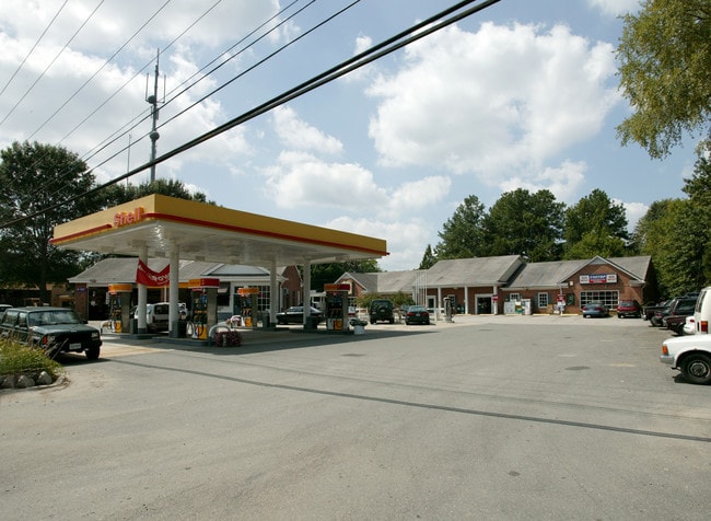
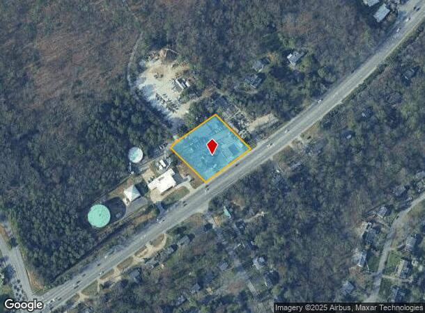
Property Record
8762 W Huguenot Rd, Richmond, VA 23235
NEARBY LISTINGS FOR SALE OR LEASE
Property Detail
8762 W Huguenot Rd
C001-0891-022
0230.00X0220.00 IRG0001.140 AC
Autorepair
Richmond City
X
Virginia
5101290016E
1.14 AC
2025
Midlothian West
2025
Richmond VA
070100
Richmond, VA
6,122 SF
DEMOGRAPHICS near 8762 W Huguenot Rd
1 Mile
3 Mile
5 Mile
2024 Total Population
5,178
49,654
177,634
2029 Population
5,423
52,077
184,395
Pop Growth 2024-2029
+ 4.73%
+ 4.88%
+ 3.81%
Average Age
46
42
41
2024 Total Households
2,314
20,280
75,291
HH Growth 2024-2029
+ 4.41%
+ 4.92%
+ 3.65%
Median Household Inc
$95,340
$84,779
$82,409
Avg Household Size
2.20
2.30
2.30
2024 Avg HH Vehicles
2.00
2.00
2.00
Median Home Value
$360,465
$353,038
$355,750
Median Year Built
1967
1975
1971
Nearby Places
Map Layers
Map Styles
 Street
 Aerial
- Restaurants
- Banks
- Shops
- Fitness
- Groceries
PUBLIC TRANSPORTATION
COMMUTER RAIL
Richmond Staples Mill Road Amtrak Station (Carolinian - Amtrak, Northeast Regional - Amtrak, Palmetto - Amtrak, Silver Meteor - Amtrak)
DRIVE
WALK
Distance
Richmond Staples Mill Road Amtrak Station (Carolinian - Amtrak, Northeast Regional - Amtrak, Palmetto - Amtrak, Silver Meteor - Amtrak)
16 min
8.0 mi
Richmond Main Street Amtrak Station (Northeast Regional - Amtrak)
DRIVE
WALK
Distance
Richmond Main Street Amtrak Station (Northeast Regional - Amtrak)
16 min
9.7 mi
AIRPORT
Richmond International
DRIVE
WALK
Distance
Richmond International
31 min
19.7 mi
Freight Ports
Virginia Port Authority - Richmond
DRIVE
WALK
Distance
Virginia Port Authority - Richmond
24 min
13.1 mi
Nearby Properties
Address
Land Use
TOTAL SIZE
Lot Size
Zoning
Address
Land Use
TOTAL SIZE
Lot Size
Zoning
98,112 SF
71.88 AC
MULTIPLE Z
Address
Land Use
TOTAL SIZE
Lot Size
Zoning
196,592 SF
30.85 AC
R-48 MULTI
Address
Land Use
TOTAL SIZE
Lot Size
Zoning
26.88 AC
MULTIPLE Z
Address
Land Use
TOTAL SIZE
Lot Size
Zoning
178,546 SF
28.35 AC
A - AGRICU
Address
Land Use
TOTAL SIZE
Lot Size
Zoning
182,896 SF
42.37 AC
R-43 MULTI
Address
Land Use
TOTAL SIZE
Lot Size
Zoning
96,480 SF
22.17 AC
RMF - RES,
Address
Land Use
TOTAL SIZE
Lot Size
Zoning
13,781 SF
24.53 AC
RMF - RES,
Address
Land Use
TOTAL SIZE
Lot Size
Zoning
77,162 SF
26.28 AC
R-2 SINGLE
Address
Land Use
TOTAL SIZE
Lot Size
Zoning
41,805 SF
26.90 AC
O2 - CORP
Address
Land Use
TOTAL SIZE
Lot Size
Zoning
292,968 SF
24.03 AC
MULTIPLE Z
Address
Land Use
TOTAL SIZE
Lot Size
Zoning
261,000 SF
10.36 AC
RMF - RES,
Address
Land Use
TOTAL SIZE
Lot Size
Zoning
199,310 SF
1.15 AC
LAC2
Address
Land Use
TOTAL SIZE
Lot Size
Zoning
104,589 SF
32.12 AC
R7 - SINGL
Address
Land Use
TOTAL SIZE
Lot Size
Zoning
155,353 SF
26.01 AC
R-2 SINGLE
Address
Land Use
TOTAL SIZE
Lot Size
Zoning
235,098 SF
37.52 AC
R-2 SINGLE
Address
Land Use
TOTAL SIZE
Lot Size
Zoning
77,657 SF
27.17 AC
R7 - SINGL
Address
Land Use
TOTAL SIZE
Lot Size
Zoning
194,463 SF
27.32 AC
R-3 SINGLE
Address
Land Use
TOTAL SIZE
Lot Size
Zoning
100 SF
15 AC
C4 - REGIO
Address
Land Use
TOTAL SIZE
Lot Size
Zoning
191,826 SF
2.64 AC
I INSTITUT
Address
Land Use
TOTAL SIZE
Lot Size
Zoning
57,357 SF
139.18 AC
R-1 SINGLE
Address
Land Use
TOTAL SIZE
Lot Size
Zoning
166,968 SF
6 AC
R-2 SINGLE
Address
Land Use
TOTAL SIZE
Lot Size
Zoning
100 SF
9.79 AC
C4 - REGIO
Address
Land Use
TOTAL SIZE
Lot Size
Zoning
21,008 SF
32.59 AC
R-1
Address
Land Use
TOTAL SIZE
Lot Size
Zoning
106,256 SF
18.66 AC
R7 - SINGL
Address
Land Use
TOTAL SIZE
Lot Size
Zoning
20,078 SF
100 AC
A - AGRICU
Address
Land Use
TOTAL SIZE
Lot Size
Zoning
100 SF
23.61 AC
R7 - SINGL
Address
Land Use
TOTAL SIZE
Lot Size
Zoning
233,362 SF
14.06 AC
R-3 SINGLE
Address
Land Use
TOTAL SIZE
Lot Size
Zoning
65,964 SF
2.58 AC
I INSTITUT
Address
Land Use
TOTAL SIZE
Lot Size
Zoning
174,288 SF
5.39 AC
R-3 SINGLE
Address
Land Use
TOTAL SIZE
Lot Size
Zoning
102,600 SF
8.38 AC
R-2 SINGLE
The World's #1 Commercial Real Estate Marketplace
Connect with us
© 2025 CoStar Group
The information above has been obtained from sources believed reliable. While we do not doubt its accuracy we have not verified it and make no guarantee, warranty or representation about it. It is your responsibility to independently confirm its accuracy and completeness. Any projections, opinions, assumptions, or estimates used are for example only and do not represent the current or future performance of the property. The value of this transaction to you depends on tax and other factors which should be evaluated by your tax, financial, and legal advisors. You and your advisors should conduct a careful, independent investigation of the property to determine to your satisfaction the suitability of the property for your needs.