Property Record
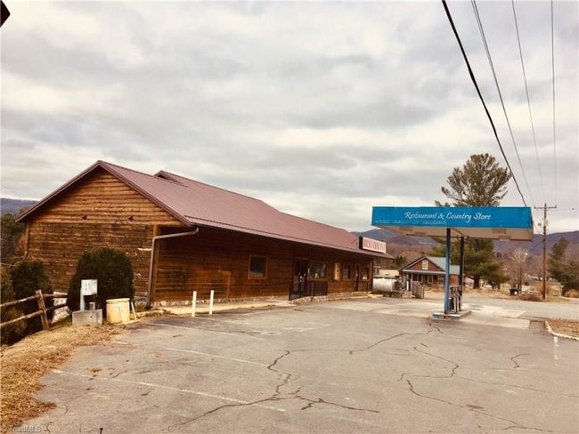
8773 W Pine St, Lowgap, NC 27024

Property Detail
8773 W Pine St
4051-03-13-8616
HWY 89
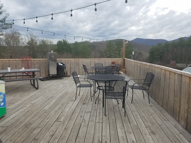
Conveniencestore
Surry
HB
North Carolina
B and X Area of moderate flood hazard, usually the area between the limits of the 100-year and 500-year floods.
0.40 AC
2025
Hickory/Morganton
2025
Other Market Areas
930803
Mount Airy, NC
4,463 SF
NEARBY LISTINGS FOR SALE OR LEASE
-
-
View all Lowgap listings for sale on LoopNet.com
DEMOGRAPHICS near 8773 W Pine St
1 mile
3 mile
5 mile
2025 Total Population
303
1,386
3,637
2030 Population
301
1,391
3,677
Pop Growth 2025-2030
(0.66%)
+ 0.36%
+ 1.10%
Average Age
43
42
43
2025 Total Households
127
565
1,480
HH Growth 2025-2030
0.00%
+ 0.18%
+ 1.01%
Median Household Inc
$55,499
$61,055
$60,185
Avg Household Size
2.40
2.40
2.40
2025 Avg HH Vehicles
2.00
2.00
2.00
Median Home Value
$129,411
$151,960
$174,507
Median Year Built
1966
1980
1983
Nearby Places
Map Layers
Map Styles
 Street
 Aerial
Transit
 Traffic
 Biking
Places
Listings with unknown addresses are not visible on the map
- Restaurants
- Banks
- Shops
- Fitness
- Groceries
SALE & LEASE HISTORY
LISTING DATE
SALE/LEASE

Jun 19, 2017
For Sale
Dec 14, 2018
For Sale
Nearby Properties
Address
Land Use
TOTAL SIZE
Lot Size
Zoning
Address
Land Use
TOTAL SIZE
Lot Size
Zoning
2,013.02 AC
RA
Address
Land Use
TOTAL SIZE
Lot Size
Zoning
8,400 SF
1.60 AC
HB-C
Address
Land Use
TOTAL SIZE
Lot Size
Zoning
4,563 SF
4.23 AC
RA
Address
Land Use
TOTAL SIZE
Lot Size
Zoning
37,650 SF
4.79 AC
RB
Address
Land Use
TOTAL SIZE
Lot Size
Zoning
2,166 SF
5.45 AC
RR
Address
Land Use
TOTAL SIZE
Lot Size
Zoning
2,786 SF
1.83 AC
HB
Address
Land Use
TOTAL SIZE
Lot Size
Zoning
141.10 AC
RA
Address
Land Use
TOTAL SIZE
Lot Size
Zoning
896 SF
173.78 AC
RR
Address
Land Use
TOTAL SIZE
Lot Size
Zoning
213.40 AC
RA
Address
Land Use
TOTAL SIZE
Lot Size
Zoning
153.47 AC
RA
Address
Land Use
TOTAL SIZE
Lot Size
Zoning
3,904 SF
1.13 AC
RA
Address
Land Use
TOTAL SIZE
Lot Size
Zoning
135.92 AC
RA
Address
Land Use
TOTAL SIZE
Lot Size
Zoning
176 AC
RA
Address
Land Use
TOTAL SIZE
Lot Size
Zoning
3.61 AC
RR
Address
Land Use
TOTAL SIZE
Lot Size
Zoning
3,500 SF
0.97 AC
HB
Address
Land Use
TOTAL SIZE
Lot Size
Zoning
76.08 AC
RA
Address
Land Use
TOTAL SIZE
Lot Size
Zoning
80.45 AC
RA
Address
Land Use
TOTAL SIZE
Lot Size
Zoning
896 SF
5.14 AC
RR
Address
Land Use
TOTAL SIZE
Lot Size
Zoning
182.48 AC
RA
Address
Land Use
TOTAL SIZE
Lot Size
Zoning
1,248 SF
58.67 AC
RA
Address
Land Use
TOTAL SIZE
Lot Size
Zoning
3,746 SF
0.50 AC
HB
Address
Land Use
TOTAL SIZE
Lot Size
Zoning
63.71 AC
RA
Address
Land Use
TOTAL SIZE
Lot Size
Zoning
56.10 AC
RA
Address
Land Use
TOTAL SIZE
Lot Size
Zoning
51.61 AC
RA
Address
Land Use
TOTAL SIZE
Lot Size
Zoning
60.35 AC
RA
Address
Land Use
TOTAL SIZE
Lot Size
Zoning
69.81 AC
RA
Address
Land Use
TOTAL SIZE
Lot Size
Zoning
4,416 SF
0.96 AC
RA
Address
Land Use
TOTAL SIZE
Lot Size
Zoning
60 AC
RA
Address
Land Use
TOTAL SIZE
Lot Size
Zoning
1,547 SF
1.21 AC
RG
The World's #1 Commercial Real Estate Marketplace
Connect with us
© 2026 CoStar Group
The information above has been obtained from sources believed reliable. While we do not doubt its accuracy we have not verified it and make no guarantee, warranty or representation about it. It is your responsibility to independently confirm its accuracy and completeness. Any projections, opinions, assumptions, or estimates used are for example only and do not represent the current or future performance of the property. The value of this transaction to you depends on tax and other factors which should be evaluated by your tax, financial, and legal advisors. You and your advisors should conduct a careful, independent investigation of the property to determine to your satisfaction the suitability of the property for your needs.