Property Record
8773 Yates Dr, Westminster, CO 80031
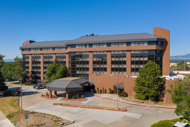

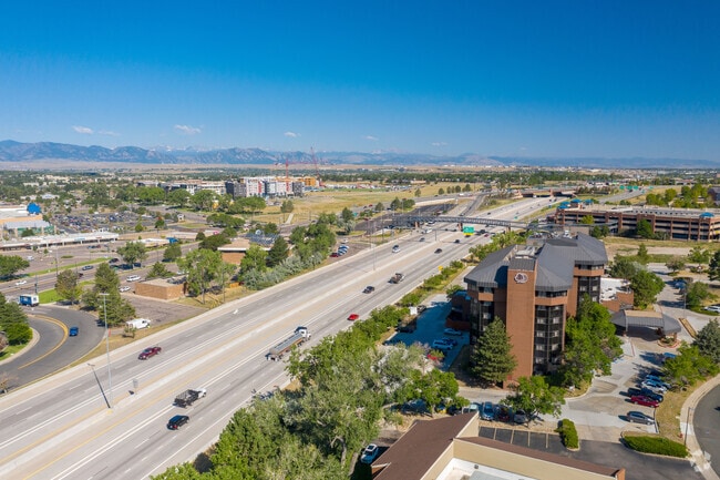

Property Detail
8773 Yates Dr
Denver-Aurora-Centennial, CO
SUB:SHERIDAN PARK NORTH FILING NO 1 DESC: PT OF BLK 2 DESC AS FOL BEG AT SW COR SEC 19/2/68 TH E 216 FT TO A PT ON ELY ROW LN U/S HIWAY 36 TH N 25D 05M 30 FT TO TRUE POB TH CONT N 25D 04M W 28 FT TH N 61D 19M E 328/46 FT TO A PT ON NON-TANG CURVE TH
1719-30-2-17-012
Adams
Hotel
Colorado
2024
5.66 AC
2025
Denver North
009401
Denver
150,200 SF
NEARBY LISTINGS FOR SALE OR LEASE
-
-
View all Westminster listings for sale on LoopNet.com
DEMOGRAPHICS near 8773 Yates Dr
1 mile
3 mile
5 mile
2025 Total Population
18,052
151,091
335,360
2030 Population
18,393
153,662
341,461
Pop Growth 2025-2030
+ 1.89%
+ 1.70%
+ 1.82%
Average Age
38
39
39
2025 Total Households
6,922
57,698
129,047
HH Growth 2025-2030
+ 1.96%
+ 1.79%
+ 1.90%
Median Household Inc
$93,137
$87,532
$92,131
Avg Household Size
2.50
2.50
2.50
2025 Avg HH Vehicles
2.00
2.00
2.00
Median Home Value
$504,017
$483,484
$520,353
Median Year Built
1975
1978
1978
Nearby Places
Map Layers
Map Styles
 Street
 Aerial
Layers
 Traffic
 Biking
Places
Listings with unknown addresses are not visible on the map
- Restaurants
- Banks
- Shops
- Fitness
- Groceries
PUBLIC TRANSPORTATION
COMMUTER RAIL
Westminster Station N-Bound (Union Station to Westminster Station - Regional Transportation District)
Drive
Walk
Distance
Westminster Station N-Bound (Union Station to Westminster Station - Regional Transportation District)
9 min
3.4 mi
Westminster Station S-Bound (Union Station to Westminster Station - Regional Transportation District)
Drive
Walk
Distance
Westminster Station S-Bound (Union Station to Westminster Station - Regional Transportation District)
8 min
4.5 mi
AIRPORT
Denver International
Drive
Walk
Distance
Denver International
38 min
29.0 mi
Freight Ports
Tulsa Port Of Catoosa
Drive
Walk
Distance
Tulsa Port Of Catoosa
735 min
714.5 mi
Nearby Properties
Address
Land Use
TOTAL SIZE
Lot Size
Zoning
Address
Land Use
TOTAL SIZE
Lot Size
Zoning
21,306 SF
2.43 AC
Address
Land Use
TOTAL SIZE
Lot Size
Zoning
559,786 SF
26.52 AC
Address
Land Use
TOTAL SIZE
Lot Size
Zoning
248,096 SF
19.67 AC
Address
Land Use
TOTAL SIZE
Lot Size
Zoning
224,600 SF
6.22 AC
Address
Land Use
TOTAL SIZE
Lot Size
Zoning
271,631 SF
12.84 AC
Address
Land Use
TOTAL SIZE
Lot Size
Zoning
216,285 SF
6 AC
Address
Land Use
TOTAL SIZE
Lot Size
Zoning
208,500 SF
8.42 AC
Address
Land Use
TOTAL SIZE
Lot Size
Zoning
176,583 SF
Address
Land Use
TOTAL SIZE
Lot Size
Zoning
117,774 SF
8.60 AC
Address
Land Use
TOTAL SIZE
Lot Size
Zoning
140,430 SF
8.39 AC
Address
Land Use
TOTAL SIZE
Lot Size
Zoning
138,912 SF
8.71 AC
Address
Land Use
TOTAL SIZE
Lot Size
Zoning
81,065 SF
4.51 AC
Address
Land Use
TOTAL SIZE
Lot Size
Zoning
113,385 SF
6.77 AC
Address
Land Use
TOTAL SIZE
Lot Size
Zoning
398,180 SF
33.31 AC
R1C
Address
Land Use
TOTAL SIZE
Lot Size
Zoning
58,750 SF
1.52 AC
Address
Land Use
TOTAL SIZE
Lot Size
Zoning
86,816 SF
4.95 AC
Address
Land Use
TOTAL SIZE
Lot Size
Zoning
79,636 SF
4.91 AC
Address
Land Use
TOTAL SIZE
Lot Size
Zoning
305,110 SF
16.87 AC
Address
Land Use
TOTAL SIZE
Lot Size
Zoning
52,194 SF
5.33 AC
Address
Land Use
TOTAL SIZE
Lot Size
Zoning
105,600 SF
1.31 AC
Address
Land Use
TOTAL SIZE
Lot Size
Zoning
209,009 SF
22.30 AC
Address
Land Use
TOTAL SIZE
Lot Size
Zoning
65,336 SF
2.86 AC
Address
Land Use
TOTAL SIZE
Lot Size
Zoning
64,106 SF
4.10 AC
Address
Land Use
TOTAL SIZE
Lot Size
Zoning
46,922 SF
2.35 AC
Address
Land Use
TOTAL SIZE
Lot Size
Zoning
74,432 SF
4.47 AC
Address
Land Use
TOTAL SIZE
Lot Size
Zoning
69,537 SF
4.49 AC
Address
Land Use
TOTAL SIZE
Lot Size
Zoning
29,986 SF
2.88 AC
Address
Land Use
TOTAL SIZE
Lot Size
Zoning
75,062 SF
5.28 AC
A1
Address
Land Use
TOTAL SIZE
Lot Size
Zoning
51,312 SF
2.17 AC
PUD
Address
Land Use
TOTAL SIZE
Lot Size
Zoning
674,481 SF
21.06 AC
The World's #1 Commercial Real Estate Marketplace
Connect with us
© 2026 CoStar Group
The information above has been obtained from sources believed reliable. While we do not doubt its accuracy we have not verified it and make no guarantee, warranty or representation about it. It is your responsibility to independently confirm its accuracy and completeness. Any projections, opinions, assumptions, or estimates used are for example only and do not represent the current or future performance of the property. The value of this transaction to you depends on tax and other factors which should be evaluated by your tax, financial, and legal advisors. You and your advisors should conduct a careful, independent investigation of the property to determine to your satisfaction the suitability of the property for your needs.