Property Record
8775 Se Federal Hwy, Hobe Sound, FL 33455

NEARBY LISTINGS FOR SALE OR LEASE
-
-
View all Hobe Sound listings for lease on LoopNet.com
Property Detail
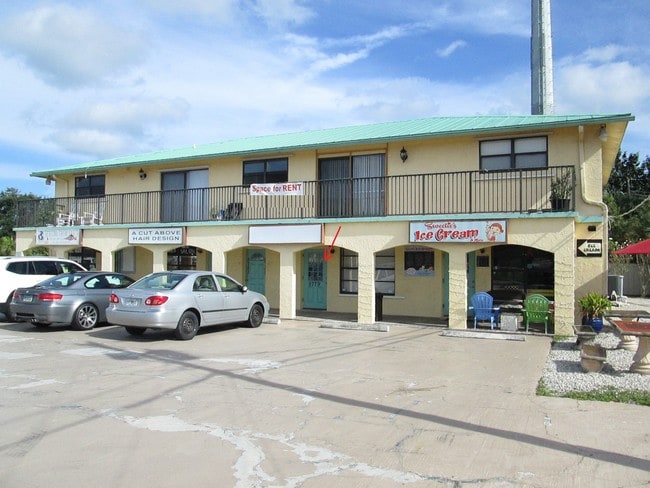
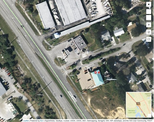
8775 Se Federal Hwy
Port St Lucie, FL
Hobe Heights
34-38-42-017-020-00440-8
HOBE HEIGHTS LOT 44 BLK T OR 345/1390
Storesoffices
Martin
X
Florida
12085C0310H
44
2024
0.54 AC
2025
Martin
001408
Port St Lucie/Fort Pierce
5,680 SF
DEMOGRAPHICS near 8775 Se Federal Hwy
1 Mile
3 Mile
5 Mile
2024 Total Population
5,271
21,669
41,579
2029 Population
5,524
22,898
43,893
Pop Growth 2024-2029
+ 4.80%
+ 5.67%
+ 5.57%
Average Age
52
53
52
2024 Total Households
2,594
10,429
19,364
HH Growth 2024-2029
+ 4.86%
+ 5.71%
+ 5.63%
Median Household Inc
$51,087
$56,654
$60,315
Avg Household Size
2.00
2.00
2.10
2024 Avg HH Vehicles
2.00
2.00
2.00
Median Home Value
$210,404
$297,023
$314,319
Median Year Built
1983
1986
1985
Nearby Places
Map Layers
Map Styles
 Street
 Aerial
- Restaurants
- Banks
- Shops
- Fitness
- Groceries
PUBLIC TRANSPORTATION
AIRPORT
Palm Beach International
DRIVE
WALK
Distance
Palm Beach International
52 min
33.6 mi
Freight Ports
Port of Palm Beach
DRIVE
WALK
Distance
Port of Palm Beach
43 min
24.7 mi
SALE & LEASE HISTORY
LISTING DATE
SALE/LEASE

Jan 03, 2020
For Lease
Nearby Properties
Address
Land Use
TOTAL SIZE
Lot Size
Zoning
Address
Land Use
TOTAL SIZE
Lot Size
Zoning
12.96 AC
LC
Address
Land Use
TOTAL SIZE
Lot Size
Zoning
106,719 SF
4.94 AC
Address
Land Use
TOTAL SIZE
Lot Size
Zoning
149,727 SF
16.82 AC
HB1
Address
Land Use
TOTAL SIZE
Lot Size
Zoning
78,591 SF
19.97 AC
PUDR
Address
Land Use
TOTAL SIZE
Lot Size
Zoning
7,488 SF
1.95 AC
D25
Address
Land Use
TOTAL SIZE
Lot Size
Zoning
50,015 SF
8.91 AC
RM8
Address
Land Use
TOTAL SIZE
Lot Size
Zoning
85,391 SF
12.47 AC
PUDC
Address
Land Use
TOTAL SIZE
Lot Size
Zoning
519.30 AC
RE2A
Address
Land Use
TOTAL SIZE
Lot Size
Zoning
6,003 SF
1.83 AC
D25
Address
Land Use
TOTAL SIZE
Lot Size
Zoning
48,930 SF
168.75 AC
PUDR
Address
Land Use
TOTAL SIZE
Lot Size
Zoning
62,809 SF
5.89 AC
R3A
Address
Land Use
TOTAL SIZE
Lot Size
Zoning
45,071 SF
455.89 AC
RM5
Address
Land Use
TOTAL SIZE
Lot Size
Zoning
Address
Land Use
TOTAL SIZE
Lot Size
Zoning
20,402 SF
13.85 AC
RS6
Address
Land Use
TOTAL SIZE
Lot Size
Zoning
960 SF
12.34 AC
TP
Address
Land Use
TOTAL SIZE
Lot Size
Zoning
81,911 SF
28.11 AC
PUDR
Address
Land Use
TOTAL SIZE
Lot Size
Zoning
29,608 SF
295.69 AC
RM5
Address
Land Use
TOTAL SIZE
Lot Size
Zoning
15,166 SF
9.41 AC
R3A
Address
Land Use
TOTAL SIZE
Lot Size
Zoning
88,192 SF
21.32 AC
PUDR
Address
Land Use
TOTAL SIZE
Lot Size
Zoning
49,536 SF
8.89 AC
R3A
Address
Land Use
TOTAL SIZE
Lot Size
Zoning
12.43 AC
PUDR
Address
Land Use
TOTAL SIZE
Lot Size
Zoning
49,725 SF
9.50 AC
R3A
Address
Land Use
TOTAL SIZE
Lot Size
Zoning
0.34 AC
Address
Land Use
TOTAL SIZE
Lot Size
Zoning
42,624 SF
8.52 AC
R3A
Address
Land Use
TOTAL SIZE
Lot Size
Zoning
44,902 SF
3.44 AC
COR1
Address
Land Use
TOTAL SIZE
Lot Size
Zoning
44,402 SF
7.05 AC
GC
Address
Land Use
TOTAL SIZE
Lot Size
Zoning
13,240 SF
1.80 AC
R3A
Address
Land Use
TOTAL SIZE
Lot Size
Zoning
443.86 AC
PS2
Address
Land Use
TOTAL SIZE
Lot Size
Zoning
813 SF
0.70 AC
E12
Address
Land Use
TOTAL SIZE
Lot Size
Zoning
14,602 SF
2.62 AC
CC
The World's #1 Commercial Real Estate Marketplace
Connect with us
© 2025 CoStar Group
The information above has been obtained from sources believed reliable. While we do not doubt its accuracy we have not verified it and make no guarantee, warranty or representation about it. It is your responsibility to independently confirm its accuracy and completeness. Any projections, opinions, assumptions, or estimates used are for example only and do not represent the current or future performance of the property. The value of this transaction to you depends on tax and other factors which should be evaluated by your tax, financial, and legal advisors. You and your advisors should conduct a careful, independent investigation of the property to determine to your satisfaction the suitability of the property for your needs.