Property Record
8775 W Us Highway 24, Cascade, CO 80809
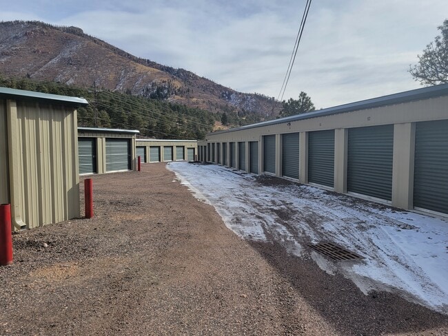

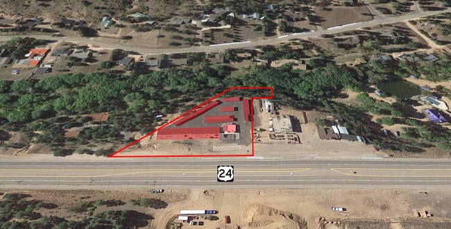
This Property Is For Sale
Property Detail
8775 W Us Highway 24
83153-00-029
TRACT IN NE4SW4 SEC 15-13-68 AS FOLS, BEG AT POI OF INTSEC OF SWLY R/W LN OF US HWY 24 & S LN OF NE4SW4, TH ALG SD R/W LN N 44<48 W 179.00 FT, TH ALG ARC OF CUR TO R HAVING A RAD OF 5780.00 FT WHOSE CHORD BEARS N 43<10 W 330.40 FT,, TH LEAVING SD R/W
Warehouse
EL PASO
CC R-T
Colorado
AE The base floodplain where base flood elevations are provided. AE Zones are now used on new format FIRMs instead of A1-A30 Zones.
1.91 AC
2024
Southwest
2025
Colorado Springs
003402
Colorado Springs, CO
10,225 SF
NEARBY LISTINGS FOR SALE OR LEASE
-
-
View all Cascade listings for sale on LoopNet.com
DEMOGRAPHICS near 8775 W Us Highway 24
1 mile
3 mile
5 mile
2024 Total Population
730
2,133
3,221
2029 Population
743
2,154
3,254
Pop Growth 2024-2029
+ 1.78%
+ 0.98%
+ 1.02%
Average Age
48
48
48
2024 Total Households
340
991
1,487
HH Growth 2024-2029
+ 2.06%
+ 1.21%
+ 1.28%
Median Household Inc
$107,500
$106,250
$98,012
Avg Household Size
2.10
2.10
2.20
2024 Avg HH Vehicles
2.00
2.00
2.00
Median Home Value
$667,721
$638,382
$656,940
Median Year Built
1977
1961
1971
Nearby Places
Map Layers
Map Styles
 Street
 Aerial
Transit
 Traffic
 Biking
Places
Listings with unknown addresses are not visible on the map
- Restaurants
- Banks
- Shops
- Fitness
- Groceries
PUBLIC TRANSPORTATION
AIRPORT
City of Colorado Springs Municipal
Drive
Walk
Distance
City of Colorado Springs Municipal
37 min
22.1 mi
Freight Ports
Tulsa Port Of Catoosa
Drive
Walk
Distance
Tulsa Port Of Catoosa
760 min
706.1 mi
Nearby Properties
Address
Land Use
TOTAL SIZE
Lot Size
Zoning
Address
Land Use
TOTAL SIZE
Lot Size
Zoning
53,716 SF
70.99 AC
R-T
Address
Land Use
TOTAL SIZE
Lot Size
Zoning
5,387.79 AC
R-T
Address
Land Use
TOTAL SIZE
Lot Size
Zoning
13,179 SF
2.01 AC
Address
Land Use
TOTAL SIZE
Lot Size
Zoning
23,817 SF
320 AC
R-T
Address
Land Use
TOTAL SIZE
Lot Size
Zoning
17,645 SF
50 AC
R-T
Address
Land Use
TOTAL SIZE
Lot Size
Zoning
4,854 SF
0.62 AC
Address
Land Use
TOTAL SIZE
Lot Size
Zoning
6,726 SF
34.29 AC
R-T
Address
Land Use
TOTAL SIZE
Lot Size
Zoning
2,855 SF
1.56 AC
Address
Land Use
TOTAL SIZE
Lot Size
Zoning
400 AC
R-T
Address
Land Use
TOTAL SIZE
Lot Size
Zoning
12,054 SF
0.60 AC
Address
Land Use
TOTAL SIZE
Lot Size
Zoning
640 AC
R-T
Address
Land Use
TOTAL SIZE
Lot Size
Zoning
880 SF
29.27 AC
R-T
Address
Land Use
TOTAL SIZE
Lot Size
Zoning
611 SF
7.14 AC
Address
Land Use
TOTAL SIZE
Lot Size
Zoning
103.14 AC
R-T
Address
Land Use
TOTAL SIZE
Lot Size
Zoning
40 AC
R-T
Address
Land Use
TOTAL SIZE
Lot Size
Zoning
3,873 SF
0.93 AC
R-T
Address
Land Use
TOTAL SIZE
Lot Size
Zoning
625 SF
9.82 AC
R-T
Address
Land Use
TOTAL SIZE
Lot Size
Zoning
80 AC
R-T
Address
Land Use
TOTAL SIZE
Lot Size
Zoning
277.50 AC
R-T
Address
Land Use
TOTAL SIZE
Lot Size
Zoning
8,493 SF
9.20 AC
C-2
Address
Land Use
TOTAL SIZE
Lot Size
Zoning
18,081 SF
27.69 AC
CR
Address
Land Use
TOTAL SIZE
Lot Size
Zoning
400 AC
R-T
Address
Land Use
TOTAL SIZE
Lot Size
Zoning
160 AC
R-T
Address
Land Use
TOTAL SIZE
Lot Size
Zoning
900 SF
3.16 AC
R-T
Address
Land Use
TOTAL SIZE
Lot Size
Zoning
374.74 AC
R-T
Address
Land Use
TOTAL SIZE
Lot Size
Zoning
19.93 AC
R-T
Address
Land Use
TOTAL SIZE
Lot Size
Zoning
2,574 SF
2.54 AC
R-T
Address
Land Use
TOTAL SIZE
Lot Size
Zoning
225 AC
R-T
Address
Land Use
TOTAL SIZE
Lot Size
Zoning
62 SF
2.40 AC
R-T
Address
Land Use
TOTAL SIZE
Lot Size
Zoning
40 AC
R-T
The World's #1 Commercial Real Estate Marketplace
Connect with us
© 2026 CoStar Group
The information above has been obtained from sources believed reliable. While we do not doubt its accuracy we have not verified it and make no guarantee, warranty or representation about it. It is your responsibility to independently confirm its accuracy and completeness. Any projections, opinions, assumptions, or estimates used are for example only and do not represent the current or future performance of the property. The value of this transaction to you depends on tax and other factors which should be evaluated by your tax, financial, and legal advisors. You and your advisors should conduct a careful, independent investigation of the property to determine to your satisfaction the suitability of the property for your needs.