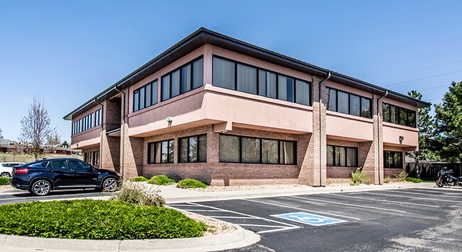
Property Record
8778 Wolff Ct, Westminster, CO 80031
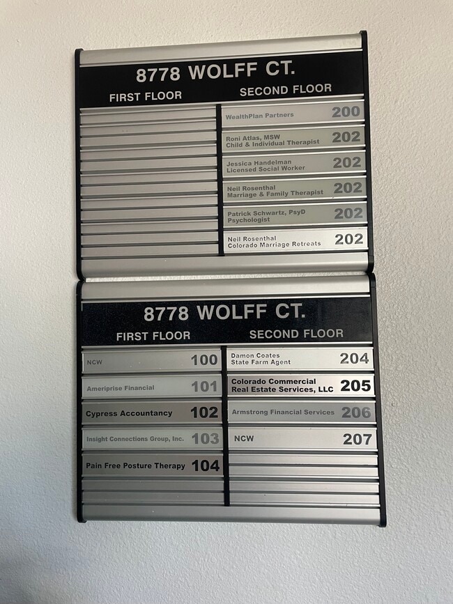

Current Lease Availabilities
Property Detail
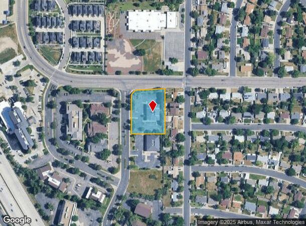
8778 Wolff Ct
Denver-Aurora-Centennial, CO
Sheridan Park Subdivision Filing No 2
1719-30-2-19-021
SUB:SHERIDAN PARK SUBDIVISION FILING NO 2 LOT:1
Officebuilding
Adams
ARE
Colorado
08059C0206F
1
2024
1.18 AC
2025
Northwest Denver
009401
Denver
12,323 SF
NEARBY LISTINGS FOR SALE OR LEASE
DEMOGRAPHICS near 8778 Wolff Ct
1 mile
3 mile
5 mile
2024 Total Population
17,639
152,598
336,362
2029 Population
18,105
155,640
343,407
Pop Growth 2024-2029
+ 2.64%
+ 1.99%
+ 2.09%
Average Age
37
39
39
2024 Total Households
6,745
58,093
128,619
HH Growth 2024-2029
+ 2.70%
+ 1.97%
+ 2.03%
Median Household Inc
$73,976
$71,626
$78,707
Avg Household Size
2.50
2.50
2.50
2024 Avg HH Vehicles
2.00
2.00
2.00
Median Home Value
$422,257
$406,306
$432,340
Median Year Built
1975
1978
1978
Nearby Places
Map Layers
Map Styles
 Street
 Aerial
Transit
 Traffic
 Biking
Places
Listings with unknown addresses are not visible on the map
- Restaurants
- Banks
- Shops
- Fitness
- Groceries
PUBLIC TRANSPORTATION
COMMUTER RAIL
Westminster Station N-Bound (Union Station to Westminster Station - Regional Transportation District)
Drive
Walk
Distance
Westminster Station N-Bound (Union Station to Westminster Station - Regional Transportation District)
8 min
3.3 mi
Westminster Station S-Bound (Union Station to Westminster Station - Regional Transportation District)
Drive
Walk
Distance
Westminster Station S-Bound (Union Station to Westminster Station - Regional Transportation District)
8 min
3.5 mi
AIRPORT
Denver International
Drive
Walk
Distance
Denver International
38 min
29.1 mi
Freight Ports
Tulsa Port Of Catoosa
Drive
Walk
Distance
Tulsa Port Of Catoosa
735 min
714.6 mi
Nearby Properties
Address
Land Use
TOTAL SIZE
Lot Size
Zoning
Address
Land Use
TOTAL SIZE
Lot Size
Zoning
21,306 SF
2.43 AC
Address
Land Use
TOTAL SIZE
Lot Size
Zoning
271,631 SF
12.84 AC
Address
Land Use
TOTAL SIZE
Lot Size
Zoning
216,285 SF
6 AC
Address
Land Use
TOTAL SIZE
Lot Size
Zoning
208,500 SF
8.42 AC
Address
Land Use
TOTAL SIZE
Lot Size
Zoning
140,430 SF
8.39 AC
Address
Land Use
TOTAL SIZE
Lot Size
Zoning
138,912 SF
8.71 AC
Address
Land Use
TOTAL SIZE
Lot Size
Zoning
113,385 SF
6.77 AC
Address
Land Use
TOTAL SIZE
Lot Size
Zoning
398,180 SF
33.31 AC
R1C
Address
Land Use
TOTAL SIZE
Lot Size
Zoning
58,750 SF
1.52 AC
Address
Land Use
TOTAL SIZE
Lot Size
Zoning
86,816 SF
4.95 AC
Address
Land Use
TOTAL SIZE
Lot Size
Zoning
79,636 SF
4.91 AC
Address
Land Use
TOTAL SIZE
Lot Size
Zoning
305,110 SF
16.87 AC
Address
Land Use
TOTAL SIZE
Lot Size
Zoning
105,600 SF
1.31 AC
Address
Land Use
TOTAL SIZE
Lot Size
Zoning
65,336 SF
2.86 AC
Address
Land Use
TOTAL SIZE
Lot Size
Zoning
64,106 SF
4.10 AC
Address
Land Use
TOTAL SIZE
Lot Size
Zoning
209,009 SF
22.30 AC
Address
Land Use
TOTAL SIZE
Lot Size
Zoning
74,432 SF
4.47 AC
Address
Land Use
TOTAL SIZE
Lot Size
Zoning
69,537 SF
4.49 AC
Address
Land Use
TOTAL SIZE
Lot Size
Zoning
51,312 SF
2.17 AC
PUD
Address
Land Use
TOTAL SIZE
Lot Size
Zoning
53,602 SF
2.37 AC
Address
Land Use
TOTAL SIZE
Lot Size
Zoning
674,481 SF
21.06 AC
Address
Land Use
TOTAL SIZE
Lot Size
Zoning
62,025 SF
2.49 AC
R4
Address
Land Use
TOTAL SIZE
Lot Size
Zoning
250,701 SF
14.14 AC
Address
Land Use
TOTAL SIZE
Lot Size
Zoning
70,338 SF
2.57 AC
Address
Land Use
TOTAL SIZE
Lot Size
Zoning
121,639 SF
25.99 AC
Address
Land Use
TOTAL SIZE
Lot Size
Zoning
114,230 SF
2.88 AC
Address
Land Use
TOTAL SIZE
Lot Size
Zoning
141,741 SF
5.58 AC
Address
Land Use
TOTAL SIZE
Lot Size
Zoning
310,000 SF
26.51 AC
Address
Land Use
TOTAL SIZE
Lot Size
Zoning
315,637 SF
8.56 AC
Address
Land Use
TOTAL SIZE
Lot Size
Zoning
155,081 SF
7.42 AC
The World's #1 Commercial Real Estate Marketplace
Connect with us
© 2026 CoStar Group
The information above has been obtained from sources believed reliable. While we do not doubt its accuracy we have not verified it and make no guarantee, warranty or representation about it. It is your responsibility to independently confirm its accuracy and completeness. Any projections, opinions, assumptions, or estimates used are for example only and do not represent the current or future performance of the property. The value of this transaction to you depends on tax and other factors which should be evaluated by your tax, financial, and legal advisors. You and your advisors should conduct a careful, independent investigation of the property to determine to your satisfaction the suitability of the property for your needs.