Property Record
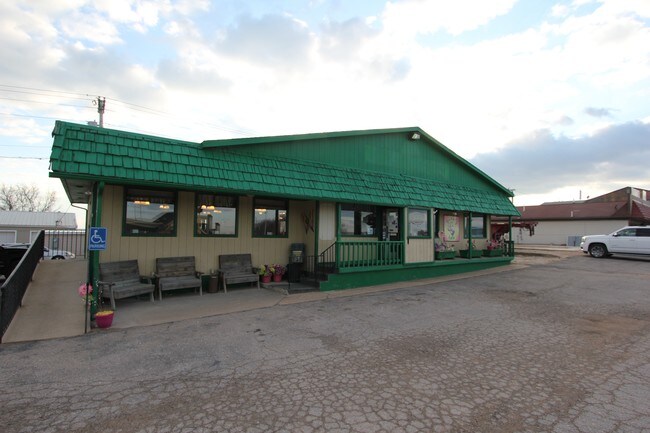
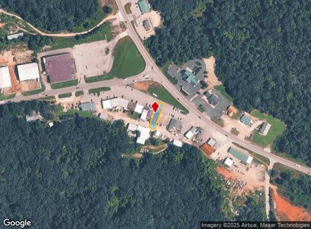
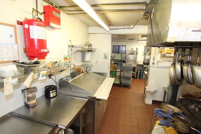
8779 N State Highway 5, Camdenton, MO 65020
NEARBY LISTINGS FOR SALE OR LEASE
-
-
View all Camdenton listings for sale on LoopNet.com
Property Detail
8779 N State Highway 5
07-9.0-29.0-000.0-002-024.000
Greenview Sub
Commercialnec
PT LOTS 16,17,29,30 BLK B AND PT ALLEY AND TRACT LAND LYING BETWEEN LOTS & HWY 5
X
Camden
29029C0205D
Missouri
2025
16,17,2
2025
0.16 AC
950302
Missouri South Central Area
2,881 SF
Other Market Areas
DEMOGRAPHICS near 8779 N State Highway 5
1 Mile
3 Mile
5 Mile
2024 Total Population
256
4,422
9,191
2029 Population
284
4,806
9,873
Pop Growth 2024-2029
+ 10.94%
+ 8.68%
+ 7.42%
Average Age
53
50
49
2024 Total Households
118
1,970
3,991
HH Growth 2024-2029
+ 9.32%
+ 7.97%
+ 6.74%
Median Household Inc
$61,731
$56,869
$56,692
Avg Household Size
2.20
2.20
2.20
2024 Avg HH Vehicles
2.00
2.00
2.00
Median Home Value
$252,173
$259,407
$265,352
Median Year Built
1992
1988
1988
Nearby Places
Map Layers
Map Styles
 Street
 Aerial
- Restaurants
- Banks
- Shops
- Fitness
- Groceries
SALE & LEASE HISTORY
LISTING DATE
SALE/LEASE

Sep 23, 2016
For Sale
Nearby Properties
Address
Land Use
TOTAL SIZE
Lot Size
Zoning
Address
Land Use
TOTAL SIZE
Lot Size
Zoning
2,356 SF
1.20 AC
Address
Land Use
TOTAL SIZE
Lot Size
Zoning
26,009 SF
2.98 AC
Address
Land Use
TOTAL SIZE
Lot Size
Zoning
1,536 SF
1.90 AC
Address
Land Use
TOTAL SIZE
Lot Size
Zoning
20.70 AC
Address
Land Use
TOTAL SIZE
Lot Size
Zoning
35,920 SF
7 AC
Address
Land Use
TOTAL SIZE
Lot Size
Zoning
0.73 AC
Address
Land Use
TOTAL SIZE
Lot Size
Zoning
Address
Land Use
TOTAL SIZE
Lot Size
Zoning
Address
Land Use
TOTAL SIZE
Lot Size
Zoning
12,480 SF
1.50 AC
Address
Land Use
TOTAL SIZE
Lot Size
Zoning
19.20 AC
Address
Land Use
TOTAL SIZE
Lot Size
Zoning
4,896 SF
2.80 AC
Address
Land Use
TOTAL SIZE
Lot Size
Zoning
Address
Land Use
TOTAL SIZE
Lot Size
Zoning
624 SF
1.40 AC
Address
Land Use
TOTAL SIZE
Lot Size
Zoning
21,984 SF
2.10 AC
Address
Land Use
TOTAL SIZE
Lot Size
Zoning
5,184 SF
1.40 AC
Address
Land Use
TOTAL SIZE
Lot Size
Zoning
17,007 SF
0.61 AC
Address
Land Use
TOTAL SIZE
Lot Size
Zoning
2,337 SF
0.67 AC
Address
Land Use
TOTAL SIZE
Lot Size
Zoning
3,924 SF
0.30 AC
Address
Land Use
TOTAL SIZE
Lot Size
Zoning
3,600 SF
0.18 AC
Address
Land Use
TOTAL SIZE
Lot Size
Zoning
Address
Land Use
TOTAL SIZE
Lot Size
Zoning
1.16 AC
Address
Land Use
TOTAL SIZE
Lot Size
Zoning
Address
Land Use
TOTAL SIZE
Lot Size
Zoning
Address
Land Use
TOTAL SIZE
Lot Size
Zoning
3,542 SF
0.35 AC
Address
Land Use
TOTAL SIZE
Lot Size
Zoning
Address
Land Use
TOTAL SIZE
Lot Size
Zoning
4,171 SF
0.30 AC
Address
Land Use
TOTAL SIZE
Lot Size
Zoning
1,430 SF
0.63 AC
Address
Land Use
TOTAL SIZE
Lot Size
Zoning
6,713 SF
0.39 AC
Address
Land Use
TOTAL SIZE
Lot Size
Zoning
Address
Land Use
TOTAL SIZE
Lot Size
Zoning
2,636 SF
0.25 AC
The World's #1 Commercial Real Estate Marketplace
Connect with us
© 2026 CoStar Group
The information above has been obtained from sources believed reliable. While we do not doubt its accuracy we have not verified it and make no guarantee, warranty or representation about it. It is your responsibility to independently confirm its accuracy and completeness. Any projections, opinions, assumptions, or estimates used are for example only and do not represent the current or future performance of the property. The value of this transaction to you depends on tax and other factors which should be evaluated by your tax, financial, and legal advisors. You and your advisors should conduct a careful, independent investigation of the property to determine to your satisfaction the suitability of the property for your needs.