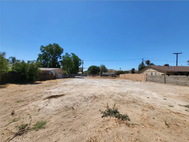
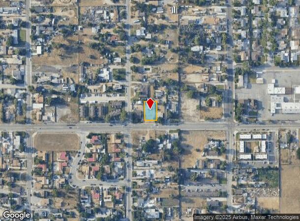
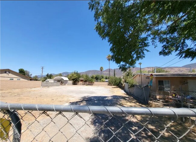
Property Record
878 W 48Th St, San Bernardino, CA 92407
NEARBY LISTINGS FOR SALE OR LEASE
Property Detail
878 W 48Th St
Riverside-San Bernardino-Ontario, CA
Arrowhead Suburban Farms
0265-131-47
ARROWHEAD SUBURBAN FARMS TR C E 80 FT W 155 FT LOTS 19 AND 20 EX N 116.25 FT THEREOF AND EX ST
Vacantlandnec
San Bernardino
X
California
06071C7945H
19,20
2024
0.23 AC
2025
San Bernardino
004509
Inland Empire (California)
DEMOGRAPHICS near 878 W 48Th St
1 Mile
3 Mile
5 Mile
2024 Total Population
19,647
93,799
231,515
2029 Population
19,912
95,068
234,703
Pop Growth 2024-2029
+ 1.35%
+ 1.35%
+ 1.38%
Average Age
34
34
34
2024 Total Households
5,822
27,050
65,338
HH Growth 2024-2029
+ 1.36%
+ 1.35%
+ 1.38%
Median Household Inc
$73,039
$68,045
$61,570
Avg Household Size
3.20
3.30
3.40
2024 Avg HH Vehicles
2.00
2.00
2.00
Median Home Value
$375,159
$356,287
$354,754
Median Year Built
1981
1965
1967
Nearby Places
Map Layers
Map Styles
 Street
 Aerial
- Restaurants
- Banks
- Shops
- Fitness
- Groceries
PUBLIC TRANSPORTATION
COMMUTER RAIL
San Bernardino (Inland Empire-Orange County Line - Southern California Regional Rail Authority (Metrolink), San Bernardino Line - Southern California Regional Rail Authority (Metrolink))
DRIVE
WALK
Distance
San Bernardino (Inland Empire-Orange County Line - Southern California Regional Rail Authority (Metrolink), San Bernardino Line - Southern California Regional Rail Authority (Metrolink))
11 min
6.1 mi
DRIVE
WALK
Distance
12 min
6.5 mi
AIRPORT
Ontario International
DRIVE
WALK
Distance
Ontario International
35 min
23.9 mi
SALE & LEASE HISTORY
LISTING DATE
SALE/LEASE

Mar 28, 2023
For Sale
Nearby Properties
Address
Land Use
TOTAL SIZE
Lot Size
Zoning
Address
Land Use
TOTAL SIZE
Lot Size
Zoning
778,653 SF
19.31 AC
Address
Land Use
TOTAL SIZE
Lot Size
Zoning
379,299 SF
19.97 AC
Address
Land Use
TOTAL SIZE
Lot Size
Zoning
340,057 SF
14.43 AC
Address
Land Use
TOTAL SIZE
Lot Size
Zoning
801,377 SF
20.81 AC
Address
Land Use
TOTAL SIZE
Lot Size
Zoning
214,534 SF
17.98 AC
Address
Land Use
TOTAL SIZE
Lot Size
Zoning
127,176 SF
18.55 AC
Address
Land Use
TOTAL SIZE
Lot Size
Zoning
277,822 SF
13.65 AC
Address
Land Use
TOTAL SIZE
Lot Size
Zoning
354,108 SF
16.93 AC
Address
Land Use
TOTAL SIZE
Lot Size
Zoning
248,368 SF
19.34 AC
Address
Land Use
TOTAL SIZE
Lot Size
Zoning
158,804 SF
5.63 AC
Address
Land Use
TOTAL SIZE
Lot Size
Zoning
272,408 SF
18.41 AC
Address
Land Use
TOTAL SIZE
Lot Size
Zoning
152,714 SF
9.99 AC
Address
Land Use
TOTAL SIZE
Lot Size
Zoning
254,500 SF
11.58 AC
Address
Land Use
TOTAL SIZE
Lot Size
Zoning
150,200 SF
10.08 AC
Address
Land Use
TOTAL SIZE
Lot Size
Zoning
448,460 SF
24.10 AC
Address
Land Use
TOTAL SIZE
Lot Size
Zoning
191,216 SF
10.28 AC
Address
Land Use
TOTAL SIZE
Lot Size
Zoning
137,200 SF
10.07 AC
Address
Land Use
TOTAL SIZE
Lot Size
Zoning
135,000 SF
8.62 AC
Address
Land Use
TOTAL SIZE
Lot Size
Zoning
173,958 SF
4.88 AC
Address
Land Use
TOTAL SIZE
Lot Size
Zoning
138,474 SF
10.55 AC
Address
Land Use
TOTAL SIZE
Lot Size
Zoning
154,590 SF
7.12 AC
Address
Land Use
TOTAL SIZE
Lot Size
Zoning
197,100 SF
7.59 AC
Address
Land Use
TOTAL SIZE
Lot Size
Zoning
217,418 SF
7.45 AC
Address
Land Use
TOTAL SIZE
Lot Size
Zoning
73,864 SF
5.44 AC
R1
Address
Land Use
TOTAL SIZE
Lot Size
Zoning
153,090 SF
9.52 AC
Address
Land Use
TOTAL SIZE
Lot Size
Zoning
173,958 SF
4.20 AC
Address
Land Use
TOTAL SIZE
Lot Size
Zoning
173,958 SF
3.39 AC
Address
Land Use
TOTAL SIZE
Lot Size
Zoning
117,253 SF
7.39 AC
Address
Land Use
TOTAL SIZE
Lot Size
Zoning
161,734 SF
7.51 AC
Address
Land Use
TOTAL SIZE
Lot Size
Zoning
129,620 SF
7.92 AC
The World's #1 Commercial Real Estate Marketplace
Connect with us
© 2025 CoStar Group
The information above has been obtained from sources believed reliable. While we do not doubt its accuracy we have not verified it and make no guarantee, warranty or representation about it. It is your responsibility to independently confirm its accuracy and completeness. Any projections, opinions, assumptions, or estimates used are for example only and do not represent the current or future performance of the property. The value of this transaction to you depends on tax and other factors which should be evaluated by your tax, financial, and legal advisors. You and your advisors should conduct a careful, independent investigation of the property to determine to your satisfaction the suitability of the property for your needs.