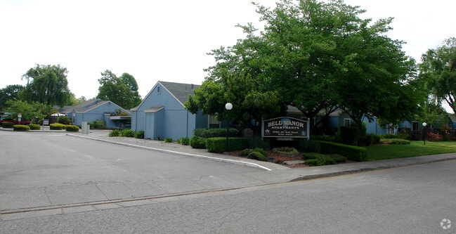
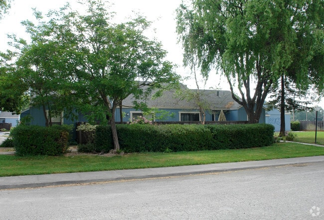
Property Record
8780 Bell Rd, Windsor, CA 95492


Save to a Folder
{{folder.Name}}
{{folder.ListingIds.length}} Properties
{{folder.ListingIds.length}} Property
Create a New Folder
Property Detail
8780 Bell Rd
164-020-004
91 FM 66-330-13 # CHG PER MD
Apartment
Sonoma
CITYWI
California
AE The base floodplain where base flood elevations are provided. AE Zones are now used on new format FIRMs instead of A1-A30 Zones.
7 AC
2025
Windsor
2025
North Bay/Santa Rosa
153808
Santa Rosa-Petaluma, CA
56,876 SF
NEARBY LISTINGS FOR SALE OR LEASE
DEMOGRAPHICS near 8780 Bell Rd
1 mile
3 mile
5 mile
2025 Total Population
15,757
28,975
40,813
2030 Population
15,711
28,886
40,722
Pop Growth 2025-2030
(0.29%)
(0.31%)
(0.22%)
Average Age
42
43
43
2025 Total Households
5,418
10,125
14,689
HH Growth 2025-2030
(0.50%)
(0.47%)
(0.33%)
Median Household Inc
$125,221
$123,852
$114,584
Avg Household Size
2.80
2.80
2.70
2025 Avg HH Vehicles
2.00
2.00
2.00
Median Home Value
$736,017
$752,305
$775,129
Median Year Built
1992
1990
1988
Nearby Places
Map Layers
Map Styles
 Street
 Aerial
Layers
 Traffic
 Biking
Places
Listings with unknown addresses are not visible on the map
- Restaurants
- Banks
- Shops
- Fitness
- Groceries
PUBLIC TRANSPORTATION
COMMUTER RAIL
Smart Santa Rosa North (Main Line - Sonoma Marin Area Rail Transit)
Drive
Walk
Distance
Smart Santa Rosa North (Main Line - Sonoma Marin Area Rail Transit)
13 min
8.8 mi
Smart Santa Rosa Downtown (Main Line - Sonoma Marin Area Rail Transit)
Drive
Walk
Distance
Smart Santa Rosa Downtown (Main Line - Sonoma Marin Area Rail Transit)
13 min
9.8 mi
AIRPORT
Charles M Schulz - Sonoma County
Drive
Walk
Distance
Charles M Schulz - Sonoma County
9 min
5.1 mi
Freight Ports
Port of Richmond
Drive
Walk
Distance
Port of Richmond
74 min
58.0 mi
Nearby Properties
Address
Land Use
TOTAL SIZE
Lot Size
Zoning
Address
Land Use
TOTAL SIZE
Lot Size
Zoning
14.56 AC
Address
Land Use
TOTAL SIZE
Lot Size
Zoning
27,302 SF
63.97 AC
Address
Land Use
TOTAL SIZE
Lot Size
Zoning
249,088 SF
10.75 AC
Address
Land Use
TOTAL SIZE
Lot Size
Zoning
126,123 SF
7.66 AC
Address
Land Use
TOTAL SIZE
Lot Size
Zoning
6,770 SF
0.18 AC
LIA60
Address
Land Use
TOTAL SIZE
Lot Size
Zoning
93,886 SF
5.40 AC
MP2
Address
Land Use
TOTAL SIZE
Lot Size
Zoning
100,186 SF
4.31 AC
Address
Land Use
TOTAL SIZE
Lot Size
Zoning
14.29 AC
Address
Land Use
TOTAL SIZE
Lot Size
Zoning
232,262 SF
30.69 AC
Address
Land Use
TOTAL SIZE
Lot Size
Zoning
18.24 AC
Address
Land Use
TOTAL SIZE
Lot Size
Zoning
129,726 SF
12.47 AC
Address
Land Use
TOTAL SIZE
Lot Size
Zoning
23,374 SF
30.07 AC
Address
Land Use
TOTAL SIZE
Lot Size
Zoning
70,358 SF
4.51 AC
M1
Address
Land Use
TOTAL SIZE
Lot Size
Zoning
282,600 SF
6.89 AC
Address
Land Use
TOTAL SIZE
Lot Size
Zoning
193,263 SF
12.31 AC
Address
Land Use
TOTAL SIZE
Lot Size
Zoning
110,289 SF
11.02 AC
Address
Land Use
TOTAL SIZE
Lot Size
Zoning
69,962 SF
4.49 AC
Address
Land Use
TOTAL SIZE
Lot Size
Zoning
70,511 SF
1.52 AC
Address
Land Use
TOTAL SIZE
Lot Size
Zoning
80,808 SF
6.92 AC
Address
Land Use
TOTAL SIZE
Lot Size
Zoning
98,033 SF
1.39 AC
Address
Land Use
TOTAL SIZE
Lot Size
Zoning
35,648 SF
2.26 AC
M1
Address
Land Use
TOTAL SIZE
Lot Size
Zoning
56,796 SF
7.59 AC
PC
Address
Land Use
TOTAL SIZE
Lot Size
Zoning
0.18 AC
Address
Land Use
TOTAL SIZE
Lot Size
Zoning
63,600 SF
3.72 AC
Address
Land Use
TOTAL SIZE
Lot Size
Zoning
63,600 SF
4.05 AC
Address
Land Use
TOTAL SIZE
Lot Size
Zoning
38,416 SF
73.01 AC
LIA20
Address
Land Use
TOTAL SIZE
Lot Size
Zoning
42,040 SF
45.09 AC
Address
Land Use
TOTAL SIZE
Lot Size
Zoning
109,620 SF
6.05 AC
Address
Land Use
TOTAL SIZE
Lot Size
Zoning
5,912 SF
5.22 AC
Address
Land Use
TOTAL SIZE
Lot Size
Zoning
59,504 SF
3.41 AC
The World's #1 Commercial Real Estate Marketplace
Connect with us
© 2026 CoStar Group
The information above has been obtained from sources believed reliable. While we do not doubt its accuracy we have not verified it and make no guarantee, warranty or representation about it. It is your responsibility to independently confirm its accuracy and completeness. Any projections, opinions, assumptions, or estimates used are for example only and do not represent the current or future performance of the property. The value of this transaction to you depends on tax and other factors which should be evaluated by your tax, financial, and legal advisors. You and your advisors should conduct a careful, independent investigation of the property to determine to your satisfaction the suitability of the property for your needs.