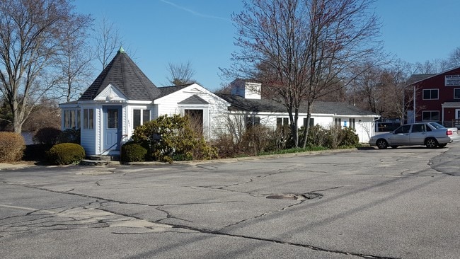
Property Record
879 Arcade Ave, Seekonk, MA 02771

Save to a Folder
{{folder.Name}}
{{folder.ListingIds.length}} Properties
{{folder.ListingIds.length}} Property
Create a New Folder
Property Detail
879 Arcade Ave
SEEK-000130-000000-000350
Bristol
Storebuilding
Massachusetts
MUR3
350
AE The base floodplain where base flood elevations are provided. AE Zones are now used on new format FIRMs instead of A1-A30 Zones.
1.02 AC
2025
Attleboro/New Bedford
2025
Boston
632200
Providence-Warwick, RI-MA
5,862 SF
NEARBY LISTINGS FOR SALE OR LEASE
DEMOGRAPHICS near 879 Arcade Ave
1 mile
3 mile
5 mile
2025 Total Population
4,809
54,301
230,512
2030 Population
4,913
56,118
237,235
Pop Growth 2025-2030
+ 2.16%
+ 3.35%
+ 2.92%
Average Age
41
43
40
2025 Total Households
1,915
23,681
93,615
HH Growth 2025-2030
+ 2.19%
+ 3.39%
+ 3.18%
Median Household Inc
$88,526
$83,133
$75,991
Avg Household Size
2.50
2.20
2.30
2025 Avg HH Vehicles
2.00
2.00
2.00
Median Home Value
$495,230
$427,221
$411,516
Median Year Built
1970
1956
1949
Nearby Places
Map Layers
Map Styles
 Street
 Aerial
Layers
 Traffic
 Biking
Places
Listings with unknown addresses are not visible on the map
- Restaurants
- Banks
- Shops
- Fitness
- Groceries
PUBLIC TRANSPORTATION
COMMUTER RAIL
Providence (Providence/Stoughton Line - Massachusetts Bay Transportation Authority Commuter Rail (Purple Line))
Drive
Walk
Distance
Providence (Providence/Stoughton Line - Massachusetts Bay Transportation Authority Commuter Rail (Purple Line))
9 min
5.2 mi
Pawtucket/Central Falls (Foxboro Event Service - MBTA, Providence/Stoughton Line - MBTA)
Drive
Walk
Distance
Pawtucket/Central Falls (Foxboro Event Service - MBTA, Providence/Stoughton Line - MBTA)
11 min
5.9 mi
AIRPORT
Rhode Island Tf Green International
Drive
Walk
Distance
Rhode Island Tf Green International
22 min
12.1 mi
Freight Ports
Port of Davisville, RI
Drive
Walk
Distance
Port of Davisville, RI
38 min
24.5 mi
SALE & LEASE HISTORY
LISTING DATE
SALE/LEASE

Apr 10, 2017
For Lease
Nearby Properties
Address
Land Use
TOTAL SIZE
Lot Size
Zoning
Address
Land Use
TOTAL SIZE
Lot Size
Zoning
317,728 SF
28.20 AC
O1
Address
Land Use
TOTAL SIZE
Lot Size
Zoning
79.57 AC
O1
Address
Land Use
TOTAL SIZE
Lot Size
Zoning
Address
Land Use
TOTAL SIZE
Lot Size
Zoning
15.20 AC
R5
Address
Land Use
TOTAL SIZE
Lot Size
Zoning
38.09 AC
CD
Address
Land Use
TOTAL SIZE
Lot Size
Zoning
455.47 AC
I3
Address
Land Use
TOTAL SIZE
Lot Size
Zoning
139.58 AC
O1
Address
Land Use
TOTAL SIZE
Lot Size
Zoning
225,067 SF
40.70 AC
HB
Address
Land Use
TOTAL SIZE
Lot Size
Zoning
6.48 AC
R-1
Address
Land Use
TOTAL SIZE
Lot Size
Zoning
8.05 AC
C1
Address
Land Use
TOTAL SIZE
Lot Size
Zoning
Address
Land Use
TOTAL SIZE
Lot Size
Zoning
18.01 AC
C3
Address
Land Use
TOTAL SIZE
Lot Size
Zoning
4.62 AC
R5
Address
Land Use
TOTAL SIZE
Lot Size
Zoning
12.67 AC
R5
Address
Land Use
TOTAL SIZE
Lot Size
Zoning
170,345 SF
3.76 AC
R6
Address
Land Use
TOTAL SIZE
Lot Size
Zoning
171,290 SF
27.80 AC
R2
Address
Land Use
TOTAL SIZE
Lot Size
Zoning
53.20 AC
C1
Address
Land Use
TOTAL SIZE
Lot Size
Zoning
225,458 SF
24.95 AC
I1
Address
Land Use
TOTAL SIZE
Lot Size
Zoning
223,374 SF
14 AC
O1
Address
Land Use
TOTAL SIZE
Lot Size
Zoning
200,200 SF
11.64 AC
I1
Address
Land Use
TOTAL SIZE
Lot Size
Zoning
87,544 SF
5.05 AC
KP
Address
Land Use
TOTAL SIZE
Lot Size
Zoning
7.44 AC
R5
Address
Land Use
TOTAL SIZE
Lot Size
Zoning
105,859 SF
16.08 AC
HB
Address
Land Use
TOTAL SIZE
Lot Size
Zoning
105,859 SF
16.08 AC
HB
Address
Land Use
TOTAL SIZE
Lot Size
Zoning
139,692 SF
15.92 AC
HB
Address
Land Use
TOTAL SIZE
Lot Size
Zoning
128,578 SF
38.89 AC
O1
Address
Land Use
TOTAL SIZE
Lot Size
Zoning
1.29 AC
R5
Address
Land Use
TOTAL SIZE
Lot Size
Zoning
153,005 SF
10.57 AC
DR
Address
Land Use
TOTAL SIZE
Lot Size
Zoning
9.81 AC
R5
Address
Land Use
TOTAL SIZE
Lot Size
Zoning
The World's #1 Commercial Real Estate Marketplace
Connect with us
© 2026 CoStar Group
The information above has been obtained from sources believed reliable. While we do not doubt its accuracy we have not verified it and make no guarantee, warranty or representation about it. It is your responsibility to independently confirm its accuracy and completeness. Any projections, opinions, assumptions, or estimates used are for example only and do not represent the current or future performance of the property. The value of this transaction to you depends on tax and other factors which should be evaluated by your tax, financial, and legal advisors. You and your advisors should conduct a careful, independent investigation of the property to determine to your satisfaction the suitability of the property for your needs.